gabel23
-
Posts
2304 -
Joined
-
Last visited
-
Days Won
5
Everything posted by gabel23
-

February 3rd-4th Plains Winter Storm
gabel23 replied to clintbeed1993's topic in East of the Rockies
-
February 3rd-4th Plains Winter Storm
gabel23 replied to clintbeed1993's topic in East of the Rockies
I really hope the nam is the winner; there is going to be such a sharp cutoff from heavy snow/no snow. With this type of system it's usually the far SE part of the state that get hammered.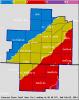
-
When you can could you post digital snow totals for the central plains?
-
February 3rd-4th Plains Winter Storm
gabel23 replied to clintbeed1993's topic in East of the Rockies
Crappy for my area, would be lucky to get 3 inches this run. Frustrating gfs is holding its ground, if euro shows the same we can throw out the nam and pull out the rest of my hair.... -
February 3rd-4th Plains Winter Storm
gabel23 replied to clintbeed1993's topic in East of the Rockies
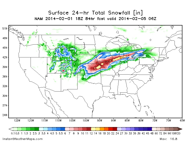
Nam holds its course, solid 6-10 for most of eastern nebraska. I really hope other models follow suit tonight.... -
I would be happy with this result. Great looking deformation band; other models not as impressive. Hopefully other models follow suit tonight....
-
February 3rd-4th Plains Winter Storm
gabel23 replied to clintbeed1993's topic in East of the Rockies
You sure would think we could get one of these! 18z gfs sucks, lucky for us it's the 18z gfs..... -
February 3rd-4th Plains Winter Storm
gabel23 replied to clintbeed1993's topic in East of the Rockies
Shift more nw please!!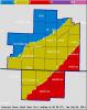
-
February 3rd-4th Plains Winter Storm
gabel23 replied to clintbeed1993's topic in East of the Rockies
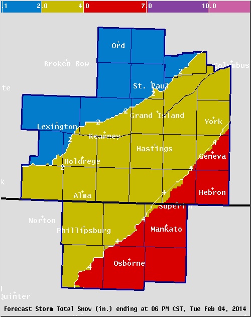
Here is what the HPC boys are thinking, need this thing to blow up to make everyone happy.....
-
February 3rd-4th Plains Winter Storm
gabel23 replied to clintbeed1993's topic in East of the Rockies
Take it with a grain of salt as it's the 18z nam, this would make all of us very happy!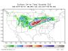
-
February 3rd-4th Plains Winter Storm
gabel23 replied to clintbeed1993's topic in East of the Rockies
Here is what kc/pleasant hill nws is thinking for storm track. Long way to go, this could wobble one way or the other.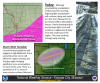
-
February 3rd-4th Plains Winter Storm
gabel23 replied to clintbeed1993's topic in East of the Rockies
If you recall the x mas blizzard of 2009 the models flipped back and forth up until 24 hrs before the event. Euro looked good plus the storm won't be on shore until tomorrow night, things could get better or worse time will tell. -
February 2014 Observations and Discussion
gabel23 replied to clintbeed1993's topic in East of the Rockies
That is crazy andie, that sounds like our area in the spring. Last year I had a severe thunderstorm warning and it was 35 degrees with ice pellets falling, not hail. Next weekends storm looks like the creme dela creme of storms, monster negative tilted low with ample moisture to work with. Interesting times ahead; just hope we get into this action from one of these storms!! -
February 3rd-4th Plains Winter Storm
gabel23 replied to clintbeed1993's topic in East of the Rockies
Went from snow likely down to a 50/50 chance. Not liking this se shift in the models, long way to go just hope this isn't a trend... -
Going to be close, good thing we are 120 hrs out. Hate to be in the sweet spot that far out. If this thing strengthens it has to go NW......
-
Looks like convection to me! I need this thing to shift NW just like next weeks storm! Your looking good in Lincoln; my area not so much........
-
Need about another 100 miles to the NW.....
-
Crazy how much snow you guys have seen. Does this push you guys into the all time record snowfall in January or just the top 5?
-
I received a trace of snow this morning; If I don't see anything from this second wave it will have been a disappointing storm to say the least.
-
February 3rd-4th Plains Winter Storm
gabel23 replied to clintbeed1993's topic in East of the Rockies
WOW been a while since I've seen that clown map look that good for our area! I wish it was here already, too many things can go wrong before this event gets here. -
February 3rd-4th Plains Winter Storm
gabel23 replied to clintbeed1993's topic in East of the Rockies
Thx for posting that Dom. Now, does that include what falls tonight or is that just what happens on Monday into Tuesday? -
February 3rd-4th Plains Winter Storm
gabel23 replied to clintbeed1993's topic in East of the Rockies
Step in the right direction with the 18z GFS. Two bad things to go with that though; still 130+ hrs out and it's the 18z GFS...... -
I'll really take anything to whiten up the ground. Been a long time since I have seen snow; kind of forget what it looks like.......Bad part with this thing is it's starting to slide off to the SE. Hasting still going with 2-3" in my area; I would be glad to see that.
-
I'll take that with just about another 50 miles to the NW served with a topping of a Negative tilted trough please. WIth how crappy it has been in my area I would be happy with one monster of a blizzard; way long time to go though until this event unfolds.
-
Just crazy, and I bet there will be numerous traffic accidents as this storm is hitting an area that just doesn't see a storm like this. I would almost have to bet some areas will see there season snow total from this one storm.