


mlgamer
-
Posts
802 -
Joined
-
Last visited
Posts posted by mlgamer
-
-
The first half of November is over and TOP has officially received 0.01" of precip for the month...basically nothing. The dry weather should continue for at least the next three days so that would make the first 18 days in November with essentially no precipitation.
-
 2
2
-
 1
1
-
 1
1
-
 3
3
-
 1
1
-
-
Yeah, start busting the drought by having a major, maybe historic, ice storm would be about right...lol


-
 4
4
-
-
With the drought still well established here, it is scary to note that it can be extremely dry over the winter. Look at how dry it was in Topeka these back-to-back winters:
Winter of 2001-2002: 0.16" of precip from 11/25/01 - 1/17/02 (54 days).
Winter of 2002-2003: 0.05" of precip from 11/15/02 - 1/14/03 (61 days).
Basically from mid-November to mid-January for two years total not even a quarter inch of precip fell!!
Hopefully this winter doesn't end up similar to these.
-
2
-
-
2 hours ago, Jayhawker85 said:
Nothing that screams a great winter for us
Yep, that's pretty much what I'm thinking so far...
-
2
-
-
Same here as the dry weather pattern continues indefinitely. Not much else to say really. Hopefully something changes for the better.

-
3
-
-
I ended up with 1.23" overall from the recent rains. Glad to have that but could have used much more. Now back to dry weather for the next week at least...

-
2
-
 1
1
-
-
21 hours ago, tStacsh said:
Love the middle fall season "cold" shots that give promise of a winter, but end up being nothing how winter will actually turn out.
This has crossed my mind as well. For example, the four Octobers of 2017-2020 all had early season measurable snowfall here with three of the four winters being nothing special with below normal snowfall. Only one winter (2018-2019) had above normal snowfall.
-
3
-
-
@MIKEKC @Tom Yeah this pattern definitely has future potential after already delivering big time in many areas this time around. Should be interesting to see what happens in future cycles over the winter.
I've been noticing this nice baroclinic zone showing up for the next system over the weekend. I haven't had one of these park in a favorable location near me for quite some time it seems. Need a nice strong storm to ride up this baby, if not this time then maybe in future cycles.

-
4
-
-
I added .01" of drizzle overnight bringing my storm total to 0.75". That's not much considering the inches upon inches that fell in areas just to the south and east. I can already see these areas getting a foot of snow later in winter while I get my standard "inch or less".

-
1
-
-
Amazingly, I added another 0.37" today so far to go with my 0.37" overnight for a storm total of 0.74". Not shabby but nothing even remotely close to the prolific totals to the south and east. Beggars can't be choosers I guess...
-
6
-
-
39 minutes ago, MIKEKC said:
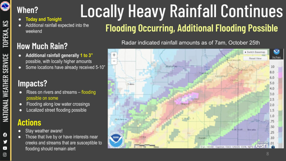
@mlgamer...look at radar, a huge area of rain just to your SW...I think you are about to go up in the rain totals...very slow moving.
Some reports of 4.5 inches of rain on the SW side of KC.
Maybe by calling out Mother Nature, I shamed her into making it rain here...lol. Then again, it appears the bulk of this heavy rain could miss me to the NW. Gets pretty comical...
Check out this graphic from NWS Topeka. I'm in the purple area (.25 - .50) just SW of Topeka. Pretty crazy totals in places.
-
1
-
-
I have received only 0.37" so far while areas less than 60 miles from me have flash flooding. Whatever long term weather pattern that causes me always to be on the short end is still in place.
@OttumwaSnomow and @Bryan1117 I hear you guys. I too believe that micro climates exist. An area roughly in a five mile radius around me has missed the beneficial rains pretty much every time this year. This goes on and on. It's hard to explain this to people because it seems so ridiculous.
It's especially noticeable in winter. It'll be 10 years in February that I have had a snowfall above 6" while areas near me have done much better. It's all very strange.

-
3
-
1
-
2
-
-
24 minutes ago, Clinton said:
SW Flow with hurricane moisture plus a strong cold front with an upper level low. It's going to be hars to miss. I understand your pessimism though with what we've endured over the last year.
Believe it or not, I'm actually up to cautiously optimistic that we may get a much needed, beneficial rain out of this. Certainly we won't get missed this time...right??!!


-
3
-
-
Not to be a Negative Nellie, but I don't have confidence in any of the global model solutions so far. For example, latest GEM (12z) has only around 0.30" QPF for me over the next seven days. That's not gonna cut it. I keep thinking of the old adage "never forecast rain in a drought". Still, plenty of time for more twists and turns...
-
5
-
-
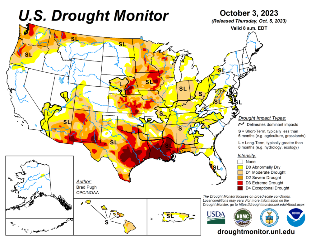
The drought continues unabated here and there is no significant rain in the forecast anytime soon. It has been particularly dry since August and it was already very dry before that. Officially, only 3.43" of rain have fallen since August 1st which is only 31% of normal. In fact, each month has gotten progressively worse in terms of percent of normal: Aug 45%, Sep 34%, Oct 14%. Not a pretty picture.
-
4
-
3
-
-
It now seems possible I could get no precip at all from this system. Maybe one quick line of storms Thursday evening/night if they even develop in my area. Just can't get a decent rain around here anymore.
-
2
-
1
-
-
4 hours ago, Clinton said:
What was looking like a big rain event for the I-70 corridor a few days ago may end up being a big rain event for the I-90 corridor leaving me with .25 in or less.
I can't even imagine the number of times we could have said this in recent years.
-
1
-
2
-
-
1 hour ago, Clinton said:
Hey now when I said I hopes you Iowa guys got some rain out of this I didn't mean all of it. Bring it back south lol!
Yikes! As Yogi Berra once said, "It's like deja vu all over again."

-
1
-
1
-
 1
1
-
-
16 hours ago, Tom said:
@Clinton @mlgamer That would hurt if I had to look south and this was a Blitz that nailed KC up to DTX! This storm showing up mid next week is going to be a signature storm track IMHO as we roll through this season. It'll be a corridor or exhibit of the new LRC pattern. The data I'm seeing as we progress into late Fall/early Winter is going to be ideally centered in this region. I don't expect to see much, if any, hard cutters this coming winter. No signs of a SER...but definite LR signs of bowling balls, CO Low's and Miller B Storms.

Well, I sure wouldn't mind seeing a few strong panhandle hooks track through my region as they used to do in the days of old. Hopefully some big share-the-wealth type of systems this winter.
-
4
-
-
The drought monitor map continues to be a mess for central, southern and southwest areas. @Clinton (and others) have mentioned some hope that a wetter pattern may begin soon so hopefully improvement is on the way.
-
4
-
-
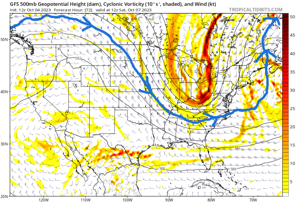
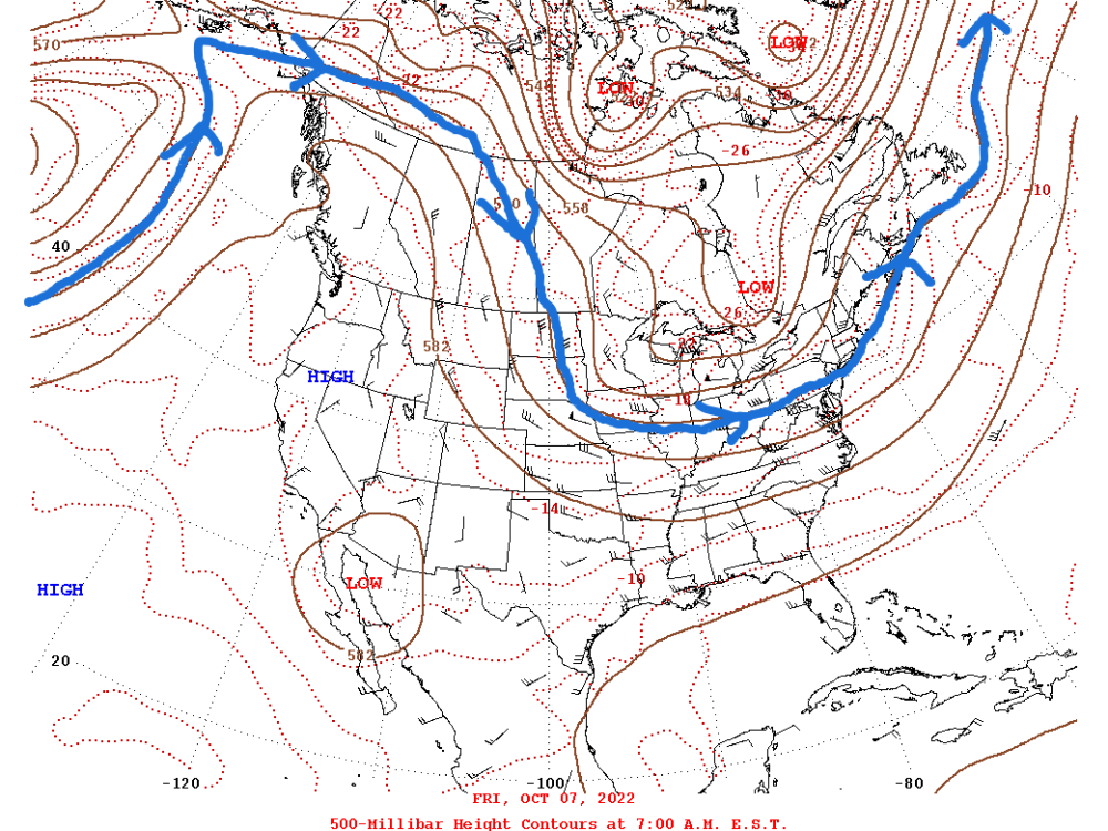
Just for fun and LRC related, here is Oct 7, 2022 and the GFS forecast for Oct 7, 2023 (12z 10/04 +72 hrs). All of the global models pretty much show this. I highlighted the 570 line. Well...not all that different really from a year ago but surely we'll have a different WETTER pattern I HOPE. lol
-
2
-
-
53 minutes ago, Tom said:
Sadly, your are is just not in the right spot but there is hope with the big block over Hudson Bay that storms will track into the Midwest later mid month. This pattern will deliver moisture, I’m pretty confident you’ll score. One thing I’m really excited about to experience in AZ are the winter storms up in Flagstaff and the White Mtns. It can dump snow and something I’m itching to experience.
As a kid growing up in the KC area, we always had the adage that when it snowed in Flagstaff it would snow in KC a couple of days later and for the most part seemed generally true reflecting snowstorms moving out of the desert southwest into the plains.
Me and the family spent a night in Flagstaff in 2015 on the way to the Grand Canyon and Zion. Flagstaff was very picturesque with the smell of the Ponderosa Pines in the air. Hope you do get a chance to enjoy some healthy snow storms there!
-
2
-
 1
1
-
-
Same old song and dance here. Only .07" of rain overnight with no substantial rain in the forecast for at least the next week or longer.
@Tom you could relocate here and notice no real differences from Arizona. Just sayin...
-
1
-
-
1 hour ago, OKwx2k4 said:
Lezak's theory holds more provable merit than many of the other weather/climate-related theories have over the same span. Its still not perfect, but I have to give dues where they are due.
You do not often respond to my posts so to be clear I believe the LRC is pretty much what Lezak claims it to be. At the time I was noting that though a "unique" whether pattern sets up each year we had had very similar winters over recent years. Overall I think there are other longer term patterns that the LRC works within that explains why we have below normal snowfall for years on end for example. Like I said, Gary understood my point and laughed about it.
-
2
-


November 2023 Observations and Discussion
in East of the Rockies
Posted
TOP has similar wording. My point forecast shows a 20% chance for snow Friday with a high of 41, so there's that.