


The Snowman
-
Posts
422 -
Joined
-
Last visited
-
Days Won
1
Everything posted by The Snowman
-
February 4-5th Possible Major Winter Storm
The Snowman replied to Tom's topic in East of the Rockies
Thanks much; while obviously we can't predict what the storm will do at this very moment, it helps to know the little tips and tricks about the models, the MJO, PNA, etc. Also (this is something I didn't put in my post), the ECMWF and its ensembles tend to have a bias to predict the PNA to be more positive than it actually ends up being. Bodes well for us and the northern track. -
February 4-5th Possible Major Winter Storm
The Snowman replied to Tom's topic in East of the Rockies
Made a new blog post on this storm with my latest thoughts. Lots of solid evidence for those of you wanting a N-ward shift: http://theweathercentre.blogspot.com/2014/01/february-4-6-potentially-significant_30.html -
Anyone have an idea of ratios for this storm? GGEM throws down 0.7" to 0.8" QPF IMBY...
-
February 2014 Observations and Discussion
The Snowman replied to Geos's topic in East of the Rockies
18z GFS is north. Good deal for N. IL. -
February 2014 Observations and Discussion
The Snowman replied to Geos's topic in East of the Rockies
Heh- there's actually a lot of quality members over there, it's just I'm not sure why some people believe the south track will remain. Models will adjust north, I have no doubt about that. -
February 2014 Observations and Discussion
The Snowman replied to Geos's topic in East of the Rockies
Highly doubting those far south solutions. Model aren't recognizing the -PNA yet- give it time, they'll adjust. -
February 2014 Observations and Discussion
The Snowman replied to Geos's topic in East of the Rockies
For anyone interested, made a post on my blog about this storm. Lots of things favoring the northward track over the southern one. http://theweathercentre.blogspot.com/2014/01/february-4-6-potentially-significant.html -
February 2014 Observations and Discussion
The Snowman replied to Geos's topic in East of the Rockies
Will end up in Canada after it cuts north into Minnesota. ... Too soon to be calling for any shifts. Heck, we don't know if we'll even have a storm. LRC supporting this storm is definitely a good sign, but we're still over a week out. -
February 2014 Observations and Discussion
The Snowman replied to Geos's topic in East of the Rockies
Agree with Tom; the LRC is supporting this event. Liking our chances here in Chicago. -
January 2014 Observations and Discussion
The Snowman replied to DominicR's topic in East of the Rockies
Looking for that west to east storm track, maybe delayed a couple days. A few indices indicating the model may have the right idea with the west-east storm track, but they want the storm to hit in February, specifically February 1-5. -
February 2014 Observations and Discussion
The Snowman replied to Geos's topic in East of the Rockies
Agreed. EPS Control snow thru Hour 360 may be a testament to the stormy pattern ahead. Highlights big storm here in IL February 4-6, which fits in relatively OK with a December 14, 2013 system that also impacted us (image of sfc, 500mb map attached as well).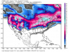
-
February 2014 Observations and Discussion
The Snowman replied to Geos's topic in East of the Rockies
As Tom alluded to, the LRC is looking quite favorable for our region as we head into February. Naturally, slight shifts and other deviations from the past cycle in mid-December can be anticipated, but the general feel of the mid/late December pattern ought to stay in place. I'm somewhat concerned about suppression with these storms, mainly for the early February system(s?), in the event the polar vortex wants to stick around in Canada. Other than that, I'm liking our chances for February. -
January 2014 Observations and Discussion
The Snowman replied to DominicR's topic in East of the Rockies
Definitely looking mighty cold when we get to the Tuesday-Wednesday timeframe. I'm usually a big winter weather fan, but I'd be OK with temperatures in the 20s and a snowstorm rather than multiple clippers in the -10s. Ah well- considering the past few winters, can't really get too picky about the wintry weather we do receive -
1/24 - 1/26 Clipper Train, and Arctic Frontal Passage
The Snowman replied to Tom's topic in East of the Rockies
Hmm. Thinking GEM is a little overdone (as is to be expected), and ECMWF is the outlier. Not around my computer now to look over all the models and such, but I'm not biting on the Euro at the moment, as everyone else has expressed. Fun times ahead... -
January 2014 Observations and Discussion
The Snowman replied to DominicR's topic in East of the Rockies
For those interested: made a new blog post on model discrepancies in the medium/long range and what we can expect after all this cold moves out to round out January. http://theweathercentre.blogspot.com/2014/01/long-range-lookout-model-confusion.html -
January 2014 Observations and Discussion
The Snowman replied to DominicR's topic in East of the Rockies
Will probably be warm in the first week of February before we see the chance for another intense cold snap February 7-10 or so. Beyond then and into Mid February, I wouldn't be surprised to see the -PNA set up shop again and our Midwestern snow chances increase as a result. -
Clipper-like Systems for January 16th-19th.
The Snowman replied to Geos's topic in East of the Rockies
Point & Click also 3-5" here. -
January 2014 Observations and Discussion
The Snowman replied to DominicR's topic in East of the Rockies
Minimum temperatures from the entire 12z GFS run compiled into this image.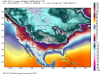
-
January 2014 Observations and Discussion
The Snowman replied to DominicR's topic in East of the Rockies
Agreed that this looks to be more of a W-E track: 12z GFS has ridging in the Gulf of Alaska, but the polar vortex displaced in Canada means more of a zonal flow situation here in the US. That said, things are looking pretty decent for storm prospects here if the recurring system does drop further south than we saw in the December cycle. MREF projections bode well for a system affecting us here as well, with guidance projecting a storm moving over central Japan on the 22nd. The 6-10 day extrapolation would have us arrive at a January 28-February 1 storm timeframe. -
January 2014 Observations and Discussion
The Snowman replied to DominicR's topic in East of the Rockies
Still liking the bitter cold to close out January and kick off February. Thinking we'll see progressive but intense waves of cold weather that could continue on through a good chunk of the month.


