The Snowman
-
Posts
422 -
Joined
-
Last visited
-
Days Won
1
Everything posted by The Snowman
-
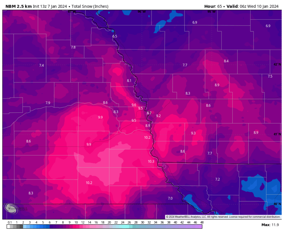
NBM upped totals by a good 1-3" across the Omaha area and vicinity compared to the post-00z and post-06z runs; now has the city set for close to 9".
-
Fascinating, models still want >6" in Omaha. Just don't see it. Would love to be wrong.
-
Not gonna lie, I would be okay if that panned out, it's too painfully comedic
-
Would be an absolutely incredible screw-hole in Omaha if this panned out verbatim.
-
GFS ensembles present some concern, but I think Omaha's actually looking pretty solid for snow. 10:1 maps probably not the most accurate for this go-around as snow will be falling in a relatively cold air mass (20s, declining as we get into the heaviest snow since it's an overnight event), but even those maps show confidence in a good 2-4". Current model-given range is 1-15" for Omaha, 3-6" seems fair right now with risks skewed a little to the upside given the consistency of the Euro and GFS.
-
Well, it makes sense a Nebraska-based member is posting Nebraska-based maps, no? There's also nothing stopping you from adding maps of different regions.
-
Too late here near Midtown, heavy snow earlier is now some sort of rain / slop.
-
NWS Omaha increases the WSW snow wording from 3-8" to 4-14" ... do not envy the forecasters in this spot: ...WINTER STORM WARNING REMAINS IN EFFECT FROM 6 AM WEDNESDAY TO 6 AM CST THURSDAY... * WHAT...Heavy mixed precipitation expected. Total snow accumulations of 4 to 14 inches and ice accumulations of around one tenth of an inch. Winds gusting as high as 35 mph. * WHERE...Portions of southwest and west central Iowa and east central, northeast and southeast Nebraska. Ice accumulations limited to west central Iowa and east central and southeast Nebraska. * WHEN...From 6 AM Wednesday to 6 AM CST Thursday.
-
NWS Omaha's thinking doesn't make a ton of sense to me. The WSW above is for 3-8" of snow, which is a relatively large range, sure, but like I showed above there isn't a single operational model showing 3" of snow for Omaha, and the mean of all guidance is about 8". Let's suppose we assume the model guidance that does show 3-5" for Omaha (looking at you, NAM) is correct. This means instead of snow, we should be expecting about half an inch of freezing rain (which doesn't appear plausible to begin with, since precip rates should be too high) and about 0.1" of sleet - again, taking the 18z NAM verbatim. But NWS Omaha of course isn't expecting nearly that much freezing rain, instead favoring less than 0.1" of ZR in the city: So if the precipitation isn't showing up via snow or freezing rain, per NWS Omaha, then the only other options are sleet and outright rain. But remember, taking the NAM verbatim, sleet is not a dominant factor in this forecast, and evaporative cooling is likely to limit sleet from getting to a significant level. Which leaves rain as the only option. But NWS Omaha's precip type graphic keeps everything in the city as either snow or some form of wintry mix: https://pbs.twimg.com/media/FmsEm3HacAAFNob?format=jpg&name=large So it seems there's a mismatch here. NWS Omaha is, from what I can see, taking the low side of model guidance in snow terms, and the low side in freezing rain, and the low side in sleet, while not accounting for any rain. The only thing I can think of that the WFO expects is for precip to come in way below what model guidance is showing, a solution that (while possible, I suppose) isn't currently forecast by any global models. Add in the 18z NBM sending snow totals way up in the city so that the expected snow total is above the high water mark in the warning text (attached image), and either NWS Omaha is seeing something I'm not, or their forecast is going to bust pretty substantially. They're trained meteorologists so I won't pretend I know which side is right, but I do know there's a mismatch between model guidance and the WFO.
-
Winter Storm Warning hoisted for Omaha:
-
One more time, this time with a few more models and everyone's three favorite statistical functions mean, median & mode added.
-
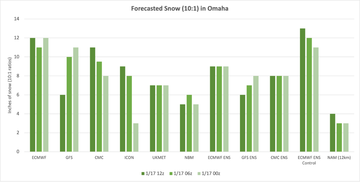
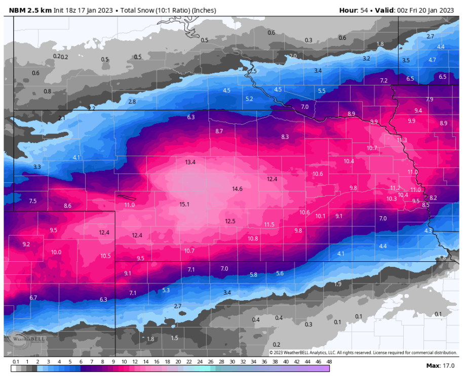
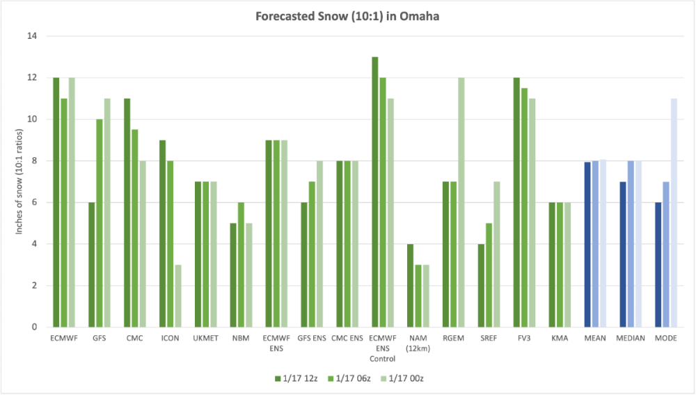
Surprising to see such a wide range in model guidance with the event about 24 hours away here in Omaha; I put together a look at the last few runs of major model guidance showing snowfall in Omaha. Used 10:1 ratio maps so as not to have totals incorrectly inflated by any sleet/ZR, which some map-making services do struggle with. As shown, the forecasted totals in Omaha range from 4" per the 12z NAM, to 13" per the 12z Euro ENS Control. Seems like a consensus is building inside a range of 6-12", probably in the vicinity of 8-10" if you want to get even more narrow. This compares to the current NWS Omaha range of 3-7" in the city. One last note, it seems that the Omaha WFO is heavily reliant on the NBM, which appears to have the second-lowest snow totals among all model guidance shown. Wondering if both the NBM and NWS Omaha need to raise their totals to be in line with latest guidance.

-
The kind of money I would pay for the Euro to be right... goodness
-
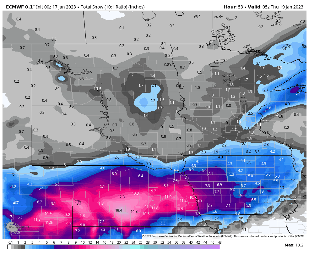
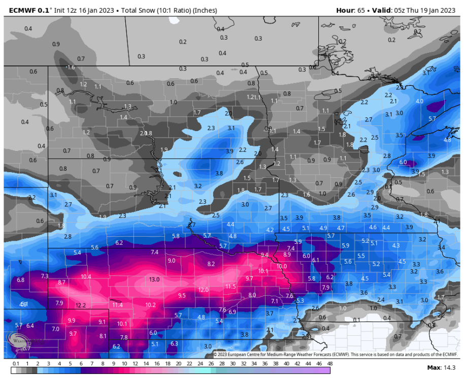
00z Euro vs 12z Euro, providing quite a jolt for Nebraska I-80 folks

-
0z Euro looking south in Nebraska...
-
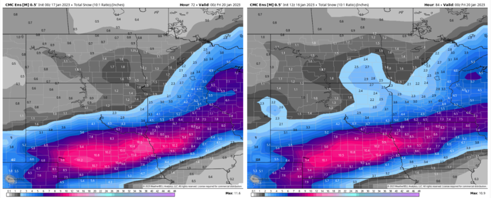
00z Canadian ensembles with a southward tick, upping Omaha totals by an inch or two (hopefully this side-by-side comparison retains its resolution being posted here)
-
As others have stated above, actually kind of impressed with how model guidance is coming in. Feels like a while since we've had a < 48hrs-from-event 00z cycle (or 12z, for that matter... really any cycle) not continuing to slash totals / pull the rug out, etc. Kind of a sad way that this is a "win" for this winter (barring a last-second collapse), but at least it's something. Going to say 5" of snow and a thick glaze of ice to make everything shiny here in Omaha. Though risks to the forecast do seem a little more skewed to the upside for snow with the 00z data in so far.
-
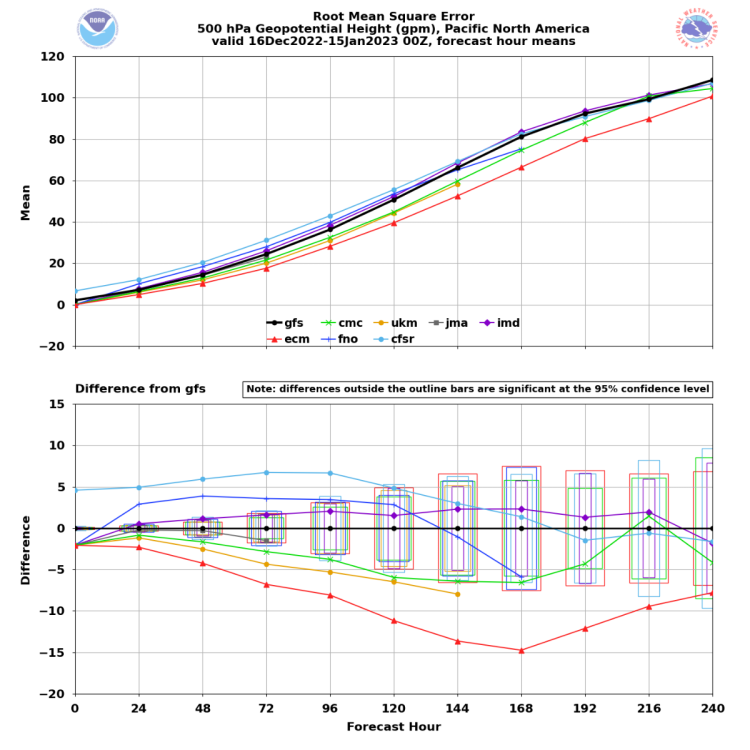
One more item, so long as I'm racking my brain... over the last 30 days, the pecking order in terms of 1-5 day model error has been: 1) ECMWF 2) UKMET(!) 3) Canadian(!!) More of a remarkable fact than something specifically pertinent to this storm
-
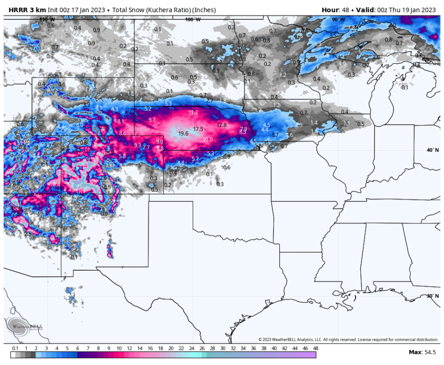
This is a good point; one could take the 00z NAM and push back with the 00z HRRR (attached thru Hour 48)... in the end they're both limited compared to the computing power of global models. Continued northern shifts in this cycle from the Canadian, ICON, GFS, Euro (especially the last two, of course) would be worth more than hi-res stuff, in my opinion.
-
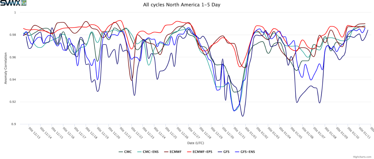
Heading into the event, model verification stats show the GFS Op lagging all other guidance when viewing North America 500mb fields in the 1-5 day forecast window. ECMWF and its ensembles setting the bar, which personally makes me less optimistic for a southward shift. Crazier things have happened, of course, but going into this event the GFS is on shaky ground.

-
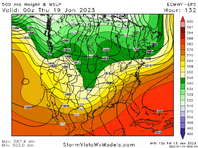
Quick observation now that all the 12z data is in; the northward trend that popped up over the last few days appears to have been the result of two modest but impactful shifts: weaker Canadian HP located just north of the Great Lakes, and stronger upstream ridging across the Southeast, both of which allow the low to 'lift' a little more north. The last couple EPS runs are showing a little backtracking, with that Canadian high being a little stronger and upstream ridging either staying the same run-over-run or even weakening just a hair. Makes me think the pendulum has swung back a bit in terms of risk to the forecast; if these trends continue, wouldn't be a surprise to see totals for southern fringe cities (i.e. Omaha) tick back up.
-
5" feels like a good starting point for Omaha. Anywhere from 3-12" in play, but NWS Omaha's range of 4-7" makes a lot of sense.
-
Trends maybe negative for >6", but still looking solid for a couple inches or more. Better than a dry slot, in my view.
-
Feeling solid about a large swath of Nebraska getting 2"+ from this system. Primary concern in my eyes is how much the expected attendant severe weather event in the Deep South will be, as far as its ability to rob moisture from the cold side of the system. Yesterday's 12z Euro seemed to show this (tracked conveniently on WeatherBell via lightning activity maps) but the projected intensity of these storms has backed off since then... whether that directly correlates to the higher snow totals overnight and today, who knows. NWS Hastings has hoisted Winter Storm Watches extending into east-central Nebraska, which I imagine puts some pressure on NWS Omaha to do something too. Given how we aren't dealing with a huge surface high pushing southeast from Canada in the wake of this storm, I don't think the risk is there's a last-minute shift southeast. Instead, with a multi-day trend of guidance gradually de-amplifying the upper-level trough responsible for this storm but maintaining the strength of simultaneous East Coast ridging, I'm more nervous about the storm trekking north like some sporadic guidance has shown recently. Would much rather be in the Tekemah, NE area than Nebraska City, for example, but Omaha looks decent too.
-
Pre-Christmas Storm Plains/MW/GL 12/21-12/22
The Snowman replied to bud2380's topic in East of the Rockies
Back in Chicagoland, not sure how to view this thing. A range of 4-20" seems fair for O'Hare, but of course that is of zero help for anyone trying to plan around the storm. Seems like we are in a high confidence situation of blizzard conditions thanks to winds gusting near 60 MPH, even if accumulations are comparatively light. Going to make for a hellacious pre-Christmas travel situation here.