GobBluth
-
Posts
1299 -
Joined
-
Last visited
Everything posted by GobBluth
-
On the 7th month of... July PNW 2022 (Preferance Wars)
GobBluth replied to The Blob's topic in West of the Rockies
The 500 mb pattern on Wednesday looks so much like last June. -
On the 7th month of... July PNW 2022 (Preferance Wars)
GobBluth replied to The Blob's topic in West of the Rockies
So less of a double wave and more a sustained hot but not extreme pattern west of Cascades? -
On the 7th month of... July PNW 2022 (Preferance Wars)
GobBluth replied to The Blob's topic in West of the Rockies
Heat returns on GFS but more the 90 degree type. -
On the 7th month of... July PNW 2022 (Preferance Wars)
GobBluth replied to The Blob's topic in West of the Rockies
Slightly, but back to the faster cooldown later in the week. -
On the 7th month of... July PNW 2022 (Preferance Wars)
GobBluth replied to The Blob's topic in West of the Rockies
Picking up any positives, but there is still disagreement on how hot we get, the EPS doesn't yet support the Euro double heat wave, and the 06 EPS is slightly cooler through next Tuesday than prior runs. -
On the 7th month of... July PNW 2022 (Preferance Wars)
GobBluth replied to The Blob's topic in West of the Rockies
Models seem to have given up on the retrograding block option. -
On the 7th month of... July PNW 2022 (Preferance Wars)
GobBluth replied to The Blob's topic in West of the Rockies
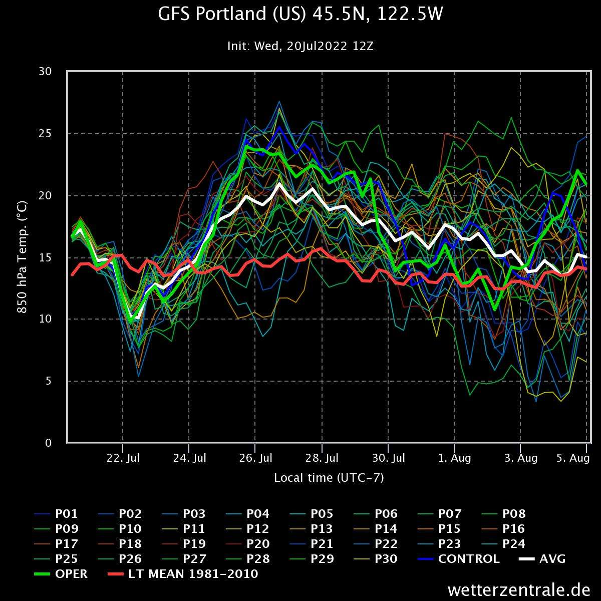
The GEFS maxes the 850s around 21 on Tuesday.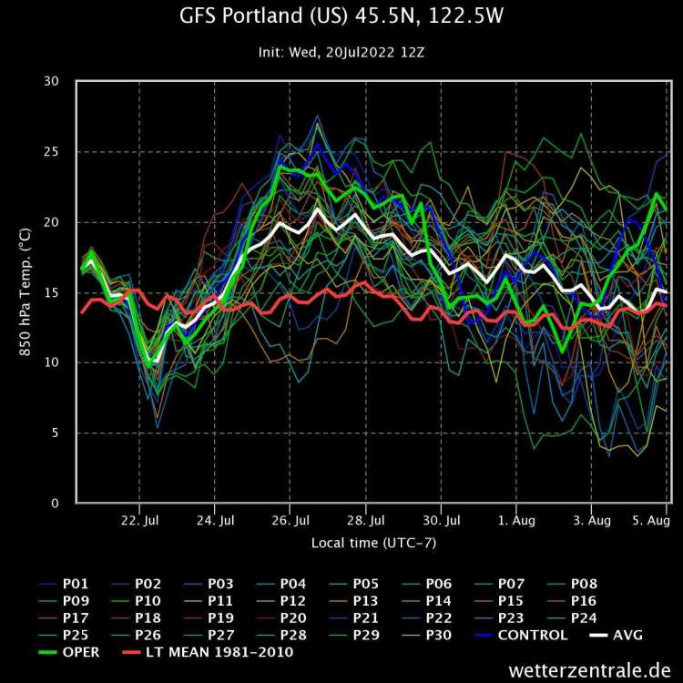
-
On the 7th month of... July PNW 2022 (Preferance Wars)
GobBluth replied to The Blob's topic in West of the Rockies
That's the joke. This is the new normal. -
PDX: Sun-86 Mon-98 Tue-103 Wed-101 Thu-96 Fri-91
-
On the 7th month of... July PNW 2022 (Preferance Wars)
GobBluth replied to The Blob's topic in West of the Rockies
Looks like the typical 100-102 heat wave that Portland gets a couple times a summer. -
On the 7th month of... July PNW 2022 (Preferance Wars)
GobBluth replied to The Blob's topic in West of the Rockies
Quicker with the heat than the 06 but also quicker to back the ridge to the west by next weekend. -
On the 7th month of... July PNW 2022 (Preferance Wars)
GobBluth replied to The Blob's topic in West of the Rockies
EPS looks quicker in the retrogression than GEFS. -
On the 7th month of... July PNW 2022 (Preferance Wars)
GobBluth replied to The Blob's topic in West of the Rockies
just referencing some of the comments others have made today. -
On the 7th month of... July PNW 2022 (Preferance Wars)
GobBluth replied to The Blob's topic in West of the Rockies
Only Thursday has vague similarities to last June, otherwise the comparison is ridiculous. What you're describing isn't crazy during the hottest time of the year. -
On the 7th month of... July PNW 2022 (Preferance Wars)
GobBluth replied to The Blob's topic in West of the Rockies
If we're looking for a positive next week during our heat, the SW is going to enter a very active phase of the monsoon. -
On the 7th month of... July PNW 2022 (Preferance Wars)
GobBluth replied to The Blob's topic in West of the Rockies
NBM peaks in the mid 90s. -
On the 7th month of... July PNW 2022 (Preferance Wars)
GobBluth replied to The Blob's topic in West of the Rockies
New GFS looks more Euro with the 850 temps next Monday and Tuesday. -
Portland NWS seems to have bumped highs tomorrow and Monday a few degrees. 100+ now likely.
-
Monsoons are going to get roaring early this year.
-
GFS moves to a large ridge forecast, at hour 360.
-
What's the story with the wildly divergent GFS and ECMWF profiles by next Wednesday?
-
entire east side looks like they may get soaking rains this weekend, not just north of the 45th parallel.
-
Mid 70s seem difficult with this overcast.
-
The ribbon of below normal precip doesn't match well with the temperature output.
-
The NBM is far drier than both the gfs and euro for the next 10 days.