
Andie
-
Posts
7138 -
Joined
-
Last visited
-
Days Won
10
Everything posted by Andie
-

Past Climates and Ice Ages
Andie replied to TT-SEA's topic in Climate, World Weather, and Earth Sciences
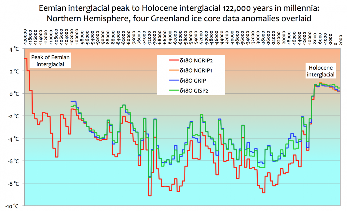
A simple straight forward look at the epochs and how history has been written on the back of climate. Warmth provides prosperity, while the cold sends us into economic and historical challenge. https://edmhdotme.wordpress.com/2015/06/01/the-holocene-context-for-anthropogenic-global-warming-2/ Our current beneficial, warm Holocene interglacial has been the enabler of mankind’s civilisation for the last 10,000 years. The congenial climate of the Holocene epoch spans from mankind’s earliest farming to the scientific and technological advances of the last 100 years. However all the Northern Hemisphere Ice Core records from Greenland show: the last millennium 1000AD – 2000AD has been the coldest millennium of the entire Holocene interglacial. each of the notable high points in the Holocene temperature record, (Holocene Climate Optimum – Minoan – Roman – Medieval – Modern), have been progressively colder than the previous high point. for its first 7-8000 years the early Holocene, including its high point “climate optimum”, had virtually flat temperatures, an average drop of only ~0.007 °C per millennium. but the more recent Holocene, since a “tipping point” at ~1000BC, has seen a temperature diminution at more than 20 times that earlier rate at about 0.14 °C per millennium. the Holocene interglacial is already 10 – 11,000 years old and judging from the length of previous interglacials the Holocene epoch should be drawing to its close: in this century, the next century or this millennium. the beneficial warming at the end of the 20th century to the Modern high point has been transmuted into the “Great Man-made Global Warming Alarm”. eventually this late 20th century temperature blip will come to be seen as just noise in the system in the longer term progress of comparatively rapid cooling over the last 3000+ years. other published Greenland Ice Core records as well as GISP2, (NGRIP1, GRIP) corroborate this finding. They also exhibit the same pattern of a prolonged relatively stable early Holocene period followed by a subsequent much more rapid decline in the more recent past. When considering the scale of temperature changes that alarmists anticipate because of Man-made Global Warming and their view of the disastrous effects of additional Man-made Carbon Dioxide emissions in this century, it is useful to look at climate change from a longer term, century by century and even on a millennial perspective.
-
We've received heavy downpours so heavy recently, it felt as though the oxygen was being pushed out of the atmosphere. Hard to breath. Many of our rains have been especially heavy. A lot of lightning. This can't be unconnected to our solar cycle.
-
Happily, we'll be dry until Tuesday when rain chances of 40%-60% return through Thursday.
-
I caught the story on the news, Tom, but this puts it in perspective. I understand Davenport does not have a heavy levy system. Being a sizable city, I asurprised. There certainly has been a lot of flooding up their way this winter and spring. Everything here is at capacity and lakes are doing controlled releasing. We're saturated.
-
We also get coronal holes. It's a weird sun, and fascinating to see and read on. Take some time Sparky and read up on it. It's affecting us all right now.
-
We had the closest thing to a cloud burst I’ve ever seen beginning around 9:30 pm it’s still raining and will go through much of the night. Unbelievable amount of rain in 45 mins. I’ll have a total in the morning if my gauge survived. This is going to be some year down here. _____________________________ Update: ..... We received 2.75" in about 40 minutes. Just an amazing downpour. Solar Minimum is definitely at play here. Strange weather year in Texas.
-
What's Up With The Solar Activity Lately?
Andie replied to snow_wizard's topic in Climate, World Weather, and Earth Sciences
No doubt our sun is at play with our weather this year. What does it bode for the coming winter of 2019-2020? _______________ Regular solar observers have noticed that since mid-2016, the Sun has occasionally been devoid of sunspots. These spotless disks will gradually become a familiar feature as the solar cycle is heading for its next minimum, currently expected by the end of this decade. The number of spotless days can vary significantly from one solar cycle transit to another. For example, during the previous minimum (around 2008), no less than 817 spotless days were recorded, whereas the minimum period leading into solar cycle 23 (around 1996) counted only 309 such blemishless days. Royal Observatory, Belgium http://www.sidc.be/silso/spotless -
LOL, we call that Texas population control. They talk about all these people from the west and east coast moving here because of the taxes, but they don't talk about how many leave after the first summer and head somewhere cooler. It's much more humid in Texas Hill Country, Central Texas. My husband won't move there, and he's an Arizona boy. The wet cooler summer that Tom has predicted for us is playing havoc with my allergies though They threatened rain for the DFW area today but it has moved south. Only a 40% chance today and tonight. We need the break. It's cool here for this time of year but it's the cloud cover.
-
High of 72* today. 70% chance of rain today, 100% tonight. Seriously damp out there. Humidity 93% this morning. It's been really dificult to get any yard work done in this environment.
-
We saw 6.75" for April's rainfall. Total to the end of April for the year, 12.87" If it triples for the year, we'll be almost 5" above average. Looks to be a wet year ahead.
-
I remember '09 and it was a very rainy and cooler summer in North Texas. Everyone was wondering what had happened? Our official rainfall was 40.89" in 2009 at the airport. Average is around 32" DFW rainfall total last year 55.97" while I had like 62.65". DFW is eastward and often times the heavier rainfall is in West Ft. Worth or the county west of it. PS - Denton reported to tornados. Both EF1. One they called a Scud Tornado.
-
Yesterday a F1 tornado struck near Tx Women’s Univ in Denton, Tx north of DFW. Trees down some property damage. We’re under a Flash Flood Watch. More storms to form. We’ll see how bumpy this one gets.
-
Small touchdown of a funnel cloud north of me last night near Denton, Tx. The strong circulation tracked just west of me last night. The atmosphere always takes on the very distinct "breathless" feeling. I love and hate it because if you aren't looking at the radar, you're left wondering where is it? Tornados are often cloaked in a curtain of heavy rain between you and it and it's very unnerving. I will as watching 2 different radars last night so I knew I was okay, but the clouds were quite something.
-
Tornado warning now. Circulation spotted 15-20 mi. west of me. No funnel cloud reported as yet. I thought it had gotten strangely quiet all of a sudden. The storm is sucking all the energy into it. Well, they spotted a rotating wall cloud but it sure would like to grow up and be a tornado. Lot's of rotation. It slipped just west of me.
-
Well, add a tornado watch to the festivities ! expires 11pm
-
They just issued a flash flood watch for over 20 counties in Texas. Rain of 1 to 2" with 6" in isolated areas are possible. Should be an interesting evening.
-
Interesting question. If it remains wet through August you should buy a Lottery ticket as that woud be very unusual ! But that said, Hurricane season can create some wild weather here in Aug. and Sept.. I've not heard much on the hurricane outlook yet. We have 10 days of straight rain forecast right now. Not totally strange for the first of May and we get some nasty storms this time of year. But so far just rain. Temps will run between mid 70's- mid 80's. Wind is strong and tons of Gulf air being pumped into the atmosphere. Strong wind between 20-30 mph, gusting higher. Rain will begin late this afternoon and should see 3-4" over the next 10 days.
-
It's okay, I love winter days in Texas. The colors and temps are nice. Everyone questions my sanity, but it's a nice golden landscape and the humidity and temps drop.
-
Tom,That's a remarkable statement. I can't say I recall a similar summer. Not that it didn't happen, I just don't remember a summer like that here. I suppose that may mean rain with that ? Also, will we not see rough storms due to cooler conditions?
-
North Texas has the potential for rain for the next 6-7 days. High Temps will range from the high 70's to mid 80's. Prime Spring storm conditions. It looks like the Southern Plains are in the storm window with Oklahoma joining the party. We'll see how the severe storm picture sizes up as the dry line moves in.
-
Same here. The potential exists for some strong storms Tuesday -Wednesday. We could see 1-3" of rain. That's on top of the 6.74" we've already received at DFW Airport. This April stands to be the 12th wettest on record. We'd have to exceed 17.64" in 1922 to beat and thankfully, that won't happen. Storms could be severe. We'll have to see how this shapes up. Lots of moving parts in this, but we'll likely get wet. It's a matter of degrees.
-
What the #$%^?!?! April 26th-28th snow event.
Andie replied to Madtown's topic in East of the Rockies
Does that include the blizzard of '78 ? That was a whopper. -
Interesting observations Tom. You are so right about evacuation problems in California. They have knitted themselves into a corner in places. I have family in Tucson. Sun and heat much of the year. Too dusty and dirty for me. I'm a Texan and we love open green spaces, big trees and blue skies. We are preparing for a wet week here. They've backed off from the 4-5" forecast and now it's more like 1-2". That's sounds more normal for this time of year. I think it will be a wet spring and into summer for us. Very windy today as well. May often delivers the strongest storms here so, we are all bracing for it.
-
Why I'm Changing My Name from LNK_Weather
Andie replied to Minny_Weather's topic in East of the Rockies
Man, I'm glad I spottedth is Post or I would have thought you were gone. Enjoy the new climate. Maybe you'll bring the stnow with you. I may be moving myself in 3 yrs but I'll still be in Texas. It would take an army to drag me out if this State. We'll be up on the Red River near Sherman and it's colder and wetter there. Lol. After this last winter, I'm second guessing my judgement. But family is there and once my husband is retired, we'll likely move to be closer. It'll be fun for you to play with your new weather zone! -
87* tomorrow with lots of sun until Tuesday when rain returns in the forecast. We should have a strong rain event from Tuesday-Sunday. We could see 5"+. Amazing. Perhaps we'll have another high rain year. Looks like the models that indicate rain here this summer are right.