


OKwx2k4
-
Posts
5472 -
Joined
-
Last visited
-
Days Won
33
Posts posted by OKwx2k4
-
-
3 hours ago, Black Hole said:
I hope we can see something like this soon!


I saw that earlier. Let the fun begin.

I've believed that fall would arrive like a crash, so this fits perfectly.
-
 4
4
-
-
On 9/26/2023 at 1:11 PM, sumweatherdude said:
Based on the current forecast, September in KC will end up several degrees above normal (we're +2 right now, and +4 if only considering daily highs). We will have had 8 of the last 10 Septembers be above normal for temps.
Got a good feeling that cycle should break soon.
The late season warm spells have made every summer seem too long for the last decade. It flips, eventually. I know it will.
I'd imagine our Marches/April's have been averaging cooler than average during the same span.
-
2
-
-
Lot of folks out west looking to kick off their snow seasons right in the next 10 days. Especially the PNW, but in fantasy ranges (240-384), every western state receives snow.
-
 3
3
-
-
-
20 hours ago, Iceresistance said:
Uhhhh O_O

Day 2 Enhanced now in place for @Black Hole and @OKwx2k4
Even though I do recommend Sunday to be enhanced based on these models, note for @AndieGoing to be a bit of a sketchy night out there folks. The 2-3 inches of rain isn't a need. Not in the fashion we're going to receive it at least. Lol.
However, old school lore says thunder in Autumn is good for snow. Starting to see a pattern I like developing.
-
2
-
-
Really glad for the nice soaking rainfall this morning.
Looking ahead, looks like we literally hold the same temps for 8-10 days straight and then a good crash is imminent. Going from 80/60 to 70/45 is going to be a good drop off but that crosses over into next month's discussion at this point.
Very glad to see our friends up north picking up much needed rainfall.
Texas should see more precip later in the season as we near late-autumn.
-
2
-
-
@Black Hole I'm really still OK with a trough in the west at this point in the game, as the westward shift in Niño hasn't really had its effects yet along with the Bering Sea still shuffling into place.
That last map is the perfect mid-autumn map. It's all coming together perfectly for cold, in my opinion.
Can almost just feel it in the air this year it seems like.
-
2
-
-
43 minutes ago, Clinton said:
Heads up @CentralNebWeatherand Oklahoma peeps.
FollowTornado potential increasing TODAY for two subtle preceding impulses across western Nebraska and southern OK into northern Texas this late afternoon and evening. Working to activate storm chase mode a day early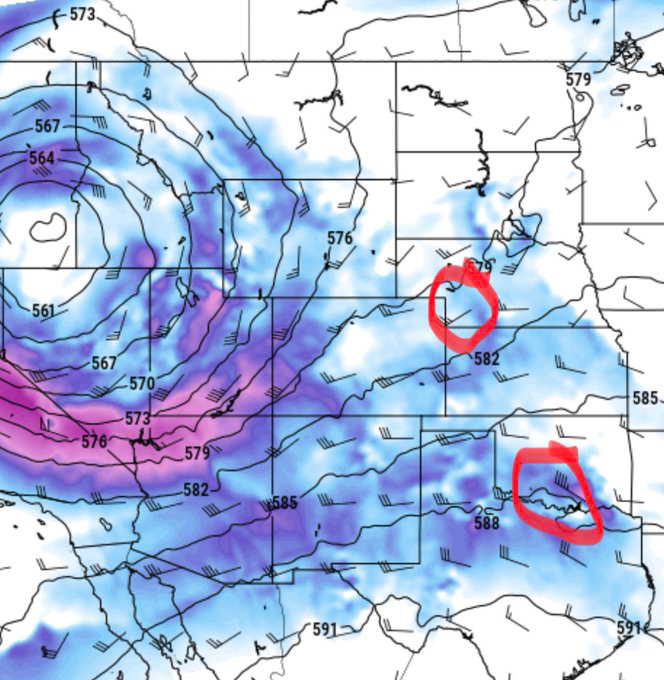
Going to be quite a day in some parts of our state, for sure.
This is definitely quite a pattern shift we have seen and much more exciting at least than "day x of heat and drought". Although not saying its cold or even cool yet for most by any stretch.
-
1
-
-
33 minutes ago, Iceresistance said:
TENNIS BALL SIZED HAIL REPORTED NEAR SHAWNEE
That's crazy stuff.
-
Basically, if this happens or even close this winter, I'll be in snow or precip for like 7 days straight.
Those maps are a HUGE blessing for those suffering drought and I'm thrilled to see it.
@Iceresistance, these storms look like they've got a little thump in them. Will be a bumpy evening.
-
2
-
-
With the AO going flat neutral for a time, will be a great 2 weeks to see the other factors influence our atmosphere and also observe the seasonal pattern progression.
Really, as some said already, watching the west coast, enso and Bering Sea weather progressions.
Would love to see a southern branch develop as we go forward.
-
3
-
-
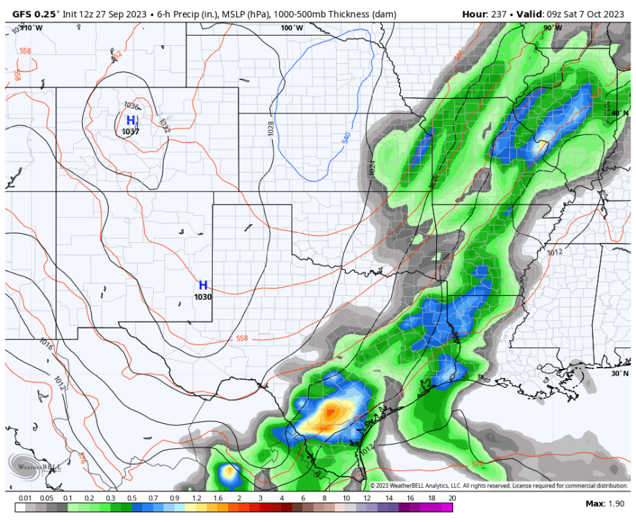
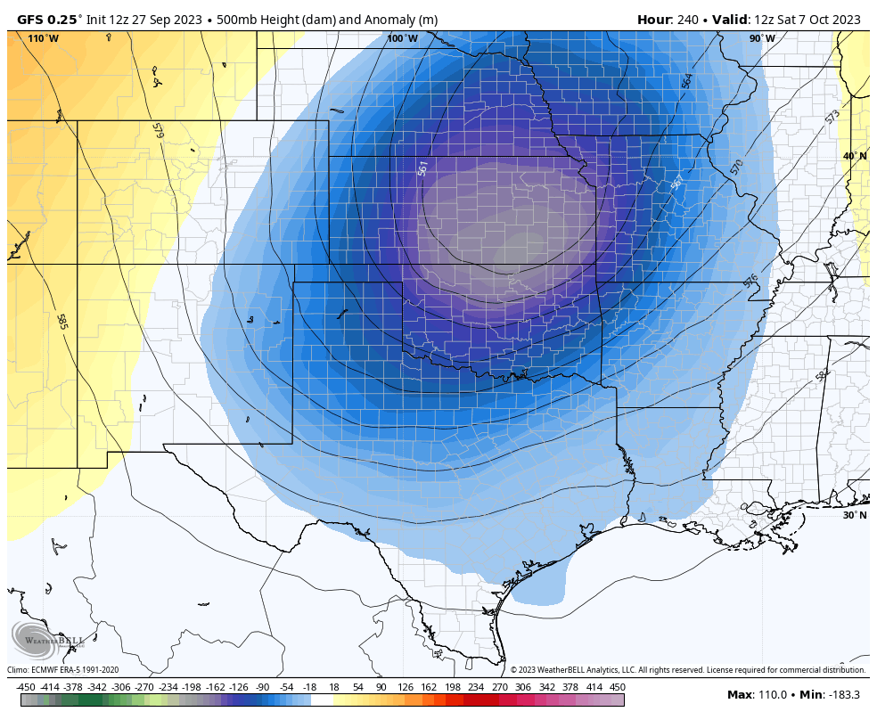
2 hours ago, Black Hole said:
 Long range GFS...I know. But I did like how it sucks a TC into a deep trough that shakes up the pattern and builds the west coast ridge. I've seen this happen plenty of times before so its possible even if not likely at this time. The downstream development drops that crazy cut off into the southern Plains.
There's good stuff all over that run for crossing into October. I agree with the emphasis on "long range" but realistically that's where this is headed.
-
3
-
-
14 minutes ago, Tom said:
This "Blocking Party" up in Canada is something else...#hudsonbayblock...its making things rather interesting tracking this autumn system that has a similar characteristic of a Bowling Ball system!
Look at that Beauty of a Block up Top...
0z GEFS 500mb animation is a wonderful way to close out SEP and open up OCT. Say Hello to the Aleutian Low!
Yeah. When it retros from GOA to Aleutians, we're in business. Lock it in!
-
1
-
-
1 hour ago, Iceresistance said:
I hope we all like rain. After this event kicks it off, we're going to look and feel like the Seattle of the south with all the clouds for the duration of the forecast.
-
1
-
 3
3
-
-
4 hours ago, Andie said:
It was certainly the east coast’s year.
I know I did speak of late-season storms razing the NE coast and "fish storms" but actually at an "invest" and 14 storms, I got the max wrong. We'll see this pattern blend into our winter pattern.
-
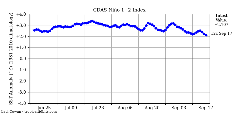
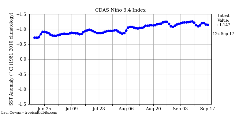
Showing signs of stability in 3.4 with declines in 1.2.
Beautiful.
-
3
-
-
With a flurry of hurricane activity these last few weeks, I've undershot the total of named storms to date at 15. I believe my max was 15 total with 3-5 majors, so I'm wrong.
Wouldn't have guessed in a Niño year that we would have spiked so high in total ace, but they're definitely not all the same.
-
2
-
-
Looking ahead through the week, our friends in the Rockies of Colorado and points NW look to record their first snowfalls if the GFS holds up.
Worth noting that for Colorado this is a month early or so as its first snows average in October.
-
3
-
-
These laye September heavy rains coming up in the forecast remind me yet again of the 2000, 2001 autumns along with 2009 and 2010.
Looking more and more like something special is shaping up in our future weather patterns.
-
3
-
1
-
-
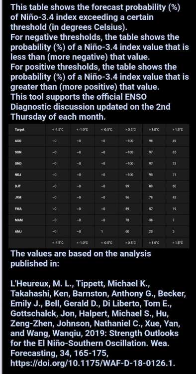
A good look at today's enso probabilities. I like how it reflects the thoughts of an earlier peak (per ideas of Tom, Black Hole and myself) as well with what could be a target of November as max.
Whether we cross and stay at the +1.5°C in 3.4 will just have to play out and see.
-
4
-
-
@Black Holedid a great job there.
A blended and delayed 2009 is still my top analog and i'll be honest, I'm nervous at what that entails seeing as I absolutely know this progression to close September is a new pattern. It looks like an '09 and 2013 mashup if I had to do it from memory.
If 2013 would have had any at all imput from an energised southern branch or any real "phasers" at all, it would have made a very great winter into a legendary one.
I want to add another factor that leads me to cold conclusions over warm and that is our retrogression coupled with the setup rolling through the Bering Sea along with the tri-pole of warm piols in perfect places up there. This tells me that the endless dumps of cool dry air into the Central Pacific are shutting down (responsible for Hawaii's drought). In fact, checking models right now, shows it.
When that's closed off and you see low after low after low literally slamming the Aleutians, you can bet something impressive is on its way.
-
2
-
-
On 9/8/2023 at 9:47 AM, Madtown said:
Obviously long range is not an exact science and many times doesn't do what it supposed to. All I've been hearing is El nino....If we take off our snow loving glasses, is it possible this winter is a massive bust, or are there enough other factors that may make it ok. Just hard to get excited for winter with El Nino in the cards.
This is a non-canonical, non- major Niño. It's evolution to west based is underway and its decline has begun.
Most typical standard El Niño forecasts are based on 2 events. 1997-98 and 2015-16. This is none of that.
Typical Major Niño events peak in January, we get flooded with Pacific air til March and suffer through a cold spring.
This event peaking 1.3c in Sept/Oct is going to radically shift that progression forward.
I love snow, but wrong is wrong and right is still right. I've pretty well held my forecast since spring and called out my own flaws, so I'd believe that my biases are all in check.
You won't hear me forecast a "record winter", just the same as it was impossible to call the extremes we have witnessed this summer. I will say that in the southern and Eastern 2/3 of the country, we should see above average snow.
-
2
-
 1
1
-
-
1 hour ago, Clinton said:
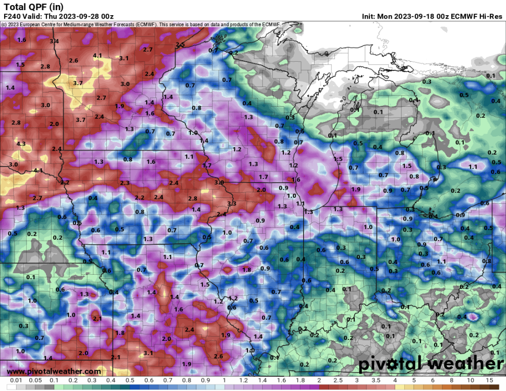
Some encouraging signs for rain in the plains showing up later on next week. Both the GFS and Euro showing the pattern turning wetter.
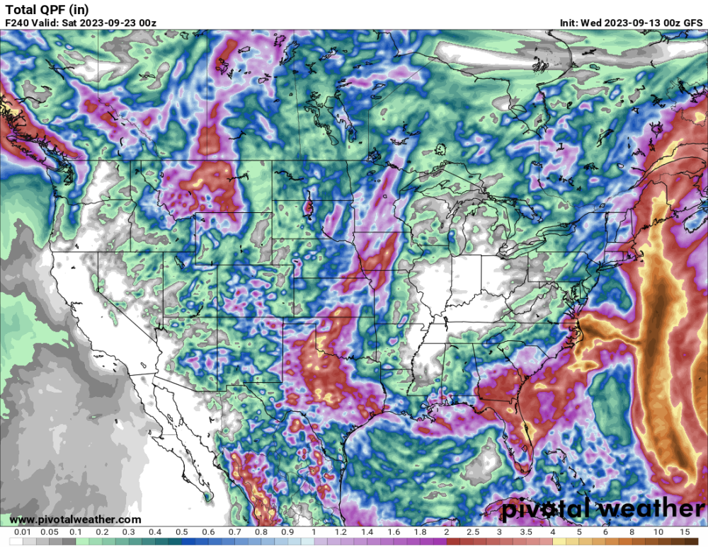
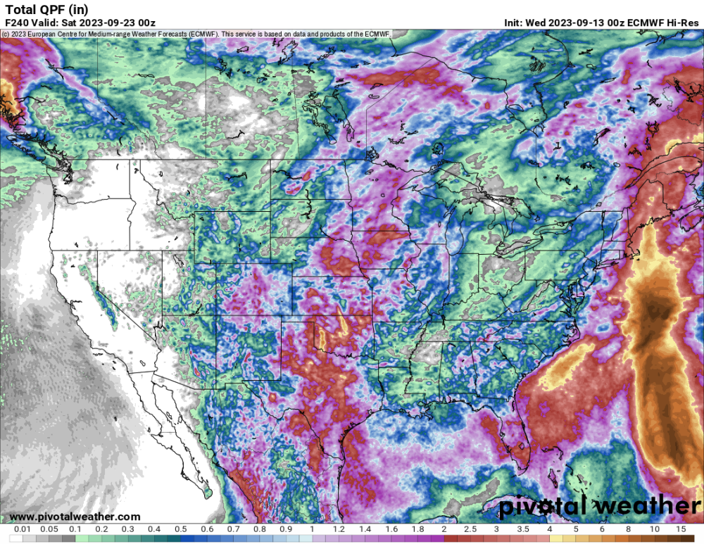
Yeah. Was coming on to note, that while there are still some large HP ridges still advertised in the longer range, both major models now starting to make those very transient and as upstream responses to incoming storms.
Big, broad-scale troughs looking to roll through the eastern 2/3 of CONUS throughout the period.
I think it is only a matter of time before these cold air masses find a continental polar source as our friends north of the border look to begin seeing their snowy season kick off in earnest.
Also, there are a lot of flooding risks developing or already in place for some our friends in the NE states.
-
2
-
-
3 minutes ago, Andie said:
We received scattered rain overnight.
69*. High of 85.
More scattered rain showers on the way.I bet that feels like a sigh of relief. Was just saying how glad I was to see that.
-
1
-


ENSO 2023
in East of the Rockies
Posted
I'd advise against any new articles that scream super Niño without even stating a forecast number.
Like some released today. There's no evidence anywhere to support a "super-Nino." None.