

VMB443
-
Posts
200 -
Joined
-
Last visited
Everything posted by VMB443
-

Valentines and Presidents Day Oklahoma and Mid West Smasher.
VMB443 replied to Clinton's topic in East of the Rockies
Here are some preliminary totals from Milwaukee area - unfortunately I was in the 4” range!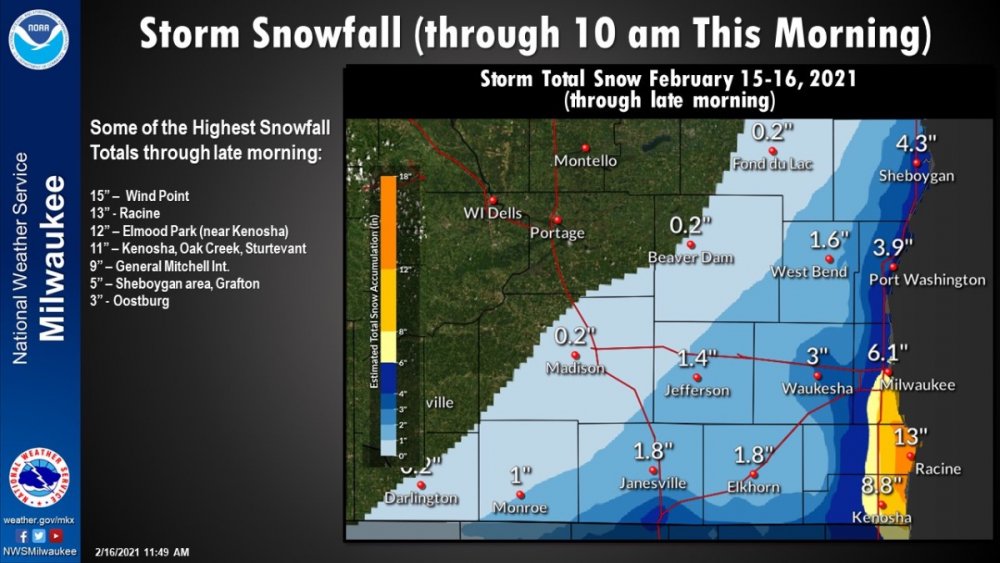
-
Nice.
-
Coming down like rain would fall - we seem to have missed - as much as I’d like more than what we will end up getting, it’s nice to get it during the daylight hours. I’m making a big pot of chili which seems appropriate with the snow and coming cold. This is winter.
-
From Milwaukee NWS: “Milwaukee had 23.3" of snow in January...the most in January since 2005! Another fun fact: While Milwaukee currently has it's highest snow depth in 10 years (16"), the max snow depth for the calendar year of 2020 was only 5". This was the lowest in a year since 1953!”
-
I think I hit close to 10” - it’s still snowing - not heavily, but it slowly adds up. I haven’t seen the snow this high in years. Roads are still messy - running out of places to go with it.
-
Milwaukee just bumped me up from 5-9 to 6-10 not a big jump, but always glad to see totals increasing this close to showtime rather than going the other way.
-
I was just reading through LOT's Twitter discussion last night - I am amazed at how many people said, "How much snow will we get in _________?" And then they'd tell them and post the snowfall map - again and again and again. LOL. They must have had the patience of saints last night.
-
Winter Storm Warning for Milwaukee. 5-9 inches. I’ll take every single one of those inches. Please.
-
Winter Storm Watch up for me 5-8 inches. Added to what is on the ground already see should have a very impressive snowpack if this comes about.
-
I’ve been lurking for awhile but just have to chime in - I’m a little bit west of Milwaukee and I’d say we have close to 8” - what a great storm.
-
MKX has an interesting discussion- seems as if they are being very tentative on things for Friday into Saturday, this seems a good explanation of why: “Models have started to trend toward a stronger deepening low that lifts NE Friday into Saturday. Previous guidance was flatter with the progression and kept some of the precip bottled up further south. This change would favor more precip wrapping into southeastern Wisconsin as the low pushes east. Now with that said, there are still some questions as to whether models have a good handle on the system. The initial low digs into MO/AR Thursday night into Friday and transitions into a closed low over the TN/OH Valleys. Then a second piece of energy digs south and this is what could cause the system to deepen as the two features phase over the OH Valley. The past few systems that have impacted the area have had a similar trend where 2-4 days (where we are currently) out models had more significant phasing and stronger lows which bumped up QPF totals. Then as you got closer in the 1-2 day period they backed off and QPF amounts trended back down. This has largely been the result of models inability to handle the phasing of closed lows. Will be keeping a close on eye on how guidance handles these features over the next few model cycles. Subtle adjustments to QPF were made with this forecast and these changes keep us below the 50th percentile for both QPF and Snow amounts. This is likely a good place to be based on the lingering uncertainty. Both GFS and ECMWF ensemble guidance are narrowing in on some of those higher QPF and snow amounts. So, if models hold onto this trend will likely continue to nudge amounts upwards. Another complicating factor is that with the low deepening warmer air gets wrapped in and temps Friday through Saturday could be such that we end up with more of a mix of rain/snow than all snow. The profile aloft is cold enough for all snow but there could be a deep enough layer near the surface to melt some of the snow. Do think models could have a slight warm bias to temps and have nudged values down slightly but this would still support a rain/snow mix.”
-
After this past weekend I can’t believe I’m being sucked into the models again. But I am!
-
1/10 - 1/11 Plains/Lower Lakes Major Winter Storm
VMB443 replied to Tom's topic in East of the Rockies
What was your user name last year when you came on to troll the board? I can’t remember now. -
1/10 - 1/11 Plains/Lower Lakes Major Winter Storm
VMB443 replied to Tom's topic in East of the Rockies
As I watch this storm dissolve into next to nothing I was thinking similar thoughts - it seems as if most forecast discussions are “this model says x, this model says y - we’ve blended them together and will update as the new runs come in.” One of things I appreciate about this forum is people using modes as a tool, rather than a crutch - I suspect too little actual forecasting goes into the forecasts and more reporting models goes on without applying them as tools combined with knowledge and experience to produce a real forecast. I often feel better informed by following you all here then I do listening the NWS forecasts. I’m not trying to simply criticize but like many things today we’ve handed over our thought process to what computers say, this is just an example of it - there is a real place for experience and knowledge that no computer can imitate. It has a piece of this puzzle but not the whole puzzle and too often forecast discussions become lazy. -
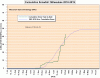
From MKX Twitter: “This is officially the snowiest start to winter at both Milwaukee and Madison by virtue of number of days with measurable snowfall to start off the winter season. - For Milwaukee this is the 6th day with measurable snowfall. The old record was 5 in 1925 and 1896 - For Madison this is the 7th day with measurable snowfall. The old record was 6 set in 1990 and 1925.“ Nice start to the season!
-
Wish the resolution on this was a bit better, but an interesting graphic from MKX
-
Is it sticking to the pavement or just the grass? Just started here maybe half an hour ago or so. So far melting on contact.
-
Picked up about two inches of fluff.
-
I’m surprised your asylum allows patients to have access to the internet.
-
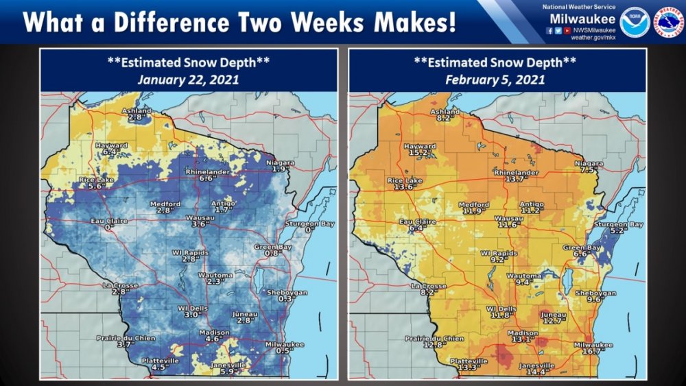
Quite the dramatic change in winter this past month.
-
2/14-2/17 Possible Winter Storm Train
VMB443 replied to Minny_Weather's topic in East of the Rockies
I’d say we had 6-7 inches here. Surprised by the amounts, the snow pack is as high as it was before the great melting of a few days ago. -
We’ve had about seven inches with a little more still falling. Hard to believe our run of true winter weather over the past three weeks or so - four real storms plus the two days of bitter cold and five school days cancelled - winter took its time getting here, but now that it’s shown up, it’s shown up with a vengeance!
-
I don’t post much because my weather knowledge is only so deep but I always look forward to your morning posts because I learn a ton - you help drive this board - that other guy, I don’t know - that guy has problems.
-
If that's the reason for staying in the Advisory for so long before moving to the Warning then that was a mistake to bow to that kind of pressure - I think they have done a really admirable job with their forecasts lately and by holding back on the Warning I think a lot of people are unprepared for what is rolling through.
-
Heavy wet snow - more impressive than the last one.


