


MKEstorm
-
Posts
136 -
Joined
-
Last visited
Recent Profile Visitors
951 profile views


MKEstorm's Achievements
")


-
January 11-13 Major Winter Storm/Blizzard
MKEstorm replied to Hoosier's topic in East of the Rockies
Final total at my house was 9 inches! Most of Milwaukee County received 8-12 inches, except for the far southeast portion near the lake which received only 1-4 inches! Most of Washington County (which is just northwest of Milwaukee County) received 16-18 inches 🫨 -
January 11-13 Major Winter Storm/Blizzard
MKEstorm replied to Hoosier's topic in East of the Rockies
Ok, yeah I’m about 8 miles west of Mitchell Airport. -
January 11-13 Major Winter Storm/Blizzard
MKEstorm replied to Hoosier's topic in East of the Rockies
Measured 4 inches as of 11:00 a.m. -
January 11-13 Major Winter Storm/Blizzard
MKEstorm replied to Hoosier's topic in East of the Rockies
Snow began around 4:00 time frame. Not sure exactly. Woke up about 4:45 and it was already snowing. Coming down pretty good now! Winds starting to pick up also! -
January 11-13 Major Winter Storm/Blizzard
MKEstorm replied to Hoosier's topic in East of the Rockies
Yeah, the mets are playing it safe with this storm, seeing what occurred near the lake yesterday. This system is much different though. It will be rapidly intensifying, whereas the storm yesterday not as much. There will be much stronger winds and also arctic air coming in behind it! Hopefully all of this can hold off any warm air off the lake. It will be interesting to see what happens. -
The Euro actually nailed the potential rain and rain snow probability for my area! I even mentioned in a post before the storm that I was concerned about this. I hope this doesn’t happen for Friday’s storm. MKX is already mentioning a possible mix near the lake during the early part of the storm. However, no model (including the Euro) is showing this! The warm Autumn and record warm December has created a very warm Lake Michigan for this time of year and it’s keeping things warmer now near the Lake.
-
This storm was a bust for my area! Only measured an inch and a half. Rain/snow mix in the morning didn’t help. The precip. changed to all snow by early afternoon and only fell moderately at times. I think the snow from the small wave coming through tonight will give me more snow than yesterday’s “storm.”
-
Currently @ 10:10 a.m….light rain & snow mix.
-
Snow has begun
-
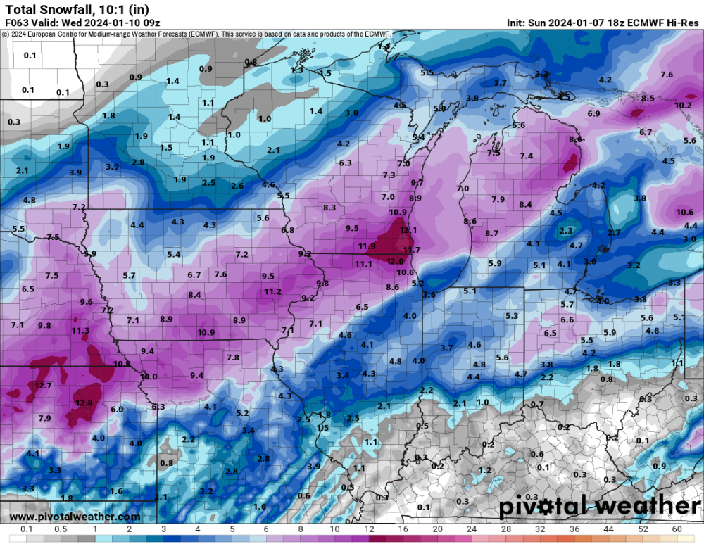
18z EURO has me in the bullseye, but has consistently put my location on the border mix rain/snow line due to it's proximity to the relatively warm (lower 40s) lake! However the 18z run has moved the mix line more east, closer to the lake. I live approximately 8 miles west of Lake Michigan. Maybe I shouldn't be too concerned about this since my NWS forecast calls for 6-10 inches!
-
MKX in their afternoon discussion mentions that models have shifted northwest a "tad". Also mentioned that the system is now coming onshore and should be better sampled. https://forecast.weather.gov/product.php?site=MKX&issuedby=MKX&product=AFD&format=CI&version=1&glossary=1 Monday through Saturday: There remains concern for a strong system to bring widespread accumulating snowfall to southern Wisconsin early next week. Latest deterministic model solutions have shifted northwest a tad more, putting the forecast area more into the heart of the higher snowfall totals. Ensemble solutions suggest a high chance (70-90%) of measurable snowfall with this system, with the chance for 3 inches or more increasing to 50-80 percent across much of southern Wisconsin. The higher snowfall probs remain across the southeast half of the forecast area. While confidence is gradually increasing in impactful snowfall, it is worth noting that there is still a sizable spread among ensemble members with the track/timing/intensity of the low. Now that the system is coming onshore across the western United States, it will be interesting to watch model trends over the next day or so with the system better sampled over land. Monday still looks dry through late afternoon as high pressure exits ahead of the approaching low. Given current model solutions, snow would then spread in from the southwest per warm air advection and frontogenesis ahead of the low. Light snow accums (1-2 inches) would be possible by daybreak Tuesday. The better forcing/moisture is currently expected to arrive by mid- afternoon Tuesday, continuing into the evening. The bulk of snow accumulations would fall during this period. Snow would then gradually wind down west to east overnight. Lake Michigan is still on the mild side, with the latest south lake water temp reading this afternoon sitting at 43 F. Given the early week system isn`t very cold, these mild lake temps could result in some rain/snow mix for lakeshore areas, though model soundings still point to mainly snow. The lake could also provide some enhancement of snowfall amounts in the east, given sfc to 850 mb temp diffs around 10C. Again, these finer details of timing and amounts will ultimately depend on the exact low track. For now though, this is the way things are trending.
-
Oh wow! They did! Nice!
-
MKX is finally getting in to really discussing this! https://forecast.weather.gov/product.php?site=MKX&issuedby=MKX&product=AFD&format=CI&version=1&glossary=1
-
January 11-13 Major Winter Storm/Blizzard
MKEstorm replied to Hoosier's topic in East of the Rockies
Buy your milk & bread NOW! -
This is the NAM at long range! I wouldn’t put too much stock into it!


