

BLI snowman
-
Posts
16253 -
Joined
-
Last visited
-
Days Won
38
Everything posted by BLI snowman
-

February 2024 Weather in the PNW
BLI snowman replied to TigerWoodsLibido's topic in West of the Rockies
Leap years have corresponded with a lot of good late February/early March action. Probably through sheer dumb luck. 1956, 1960, 1976, 1996, 2012. -
February 2024 Weather in the PNW
BLI snowman replied to TigerWoodsLibido's topic in West of the Rockies
Leap Day madness!! One more day for February to February!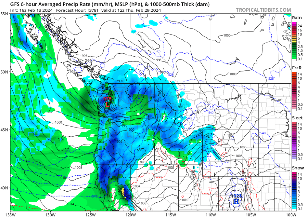
- 8823 replies
-
- 10
-

-

-

-

-

-

-
February 2024 Weather in the PNW
BLI snowman replied to TigerWoodsLibido's topic in West of the Rockies
NAM was a nice jog south. Now quite close to snow for the PDX metro on Wednesday evening. -
February 2024 Weather in the PNW
BLI snowman replied to TigerWoodsLibido's topic in West of the Rockies
At least we're not Minneapolis, where it is currently running 19 degrees above normal this month: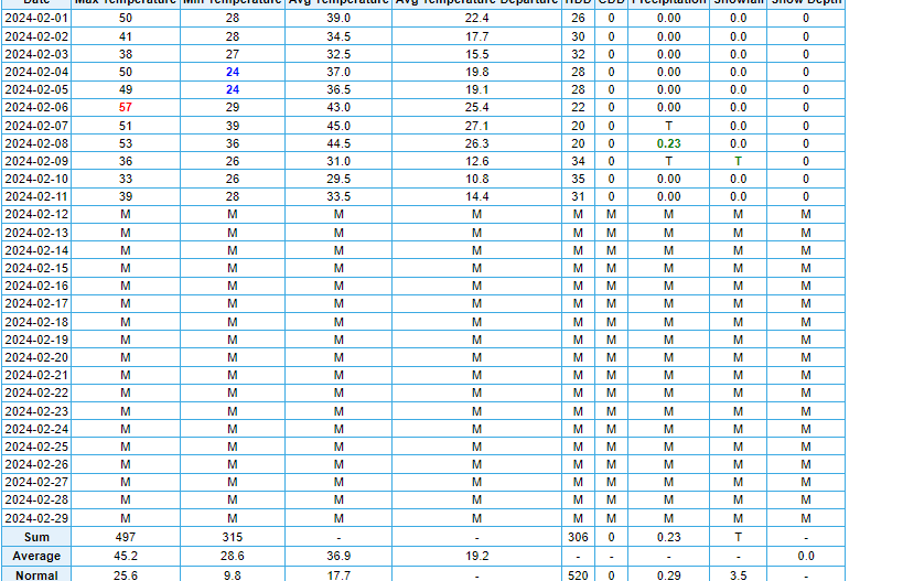
-
West Coast Sports Talk and Other Banter
BLI snowman replied to Anti Marine Layer's topic in West of the Rockies
Both of these teams are insufferable. -
He literally stumbles and bumbles through virtually every single press conference he gives. These are 10+ minute sample sizes at a time. Not 10 second Hannity Report clips. I don't know how you can observe Biden and not be alarmed by his senility.
-
February 2024 Weather in the PNW
BLI snowman replied to TigerWoodsLibido's topic in West of the Rockies
Eh, with the way things are going on the East Coast, anywhere south of Boston on the coastal plain is probably fair game now for hardy palms. -
February 2024 Weather in the PNW
BLI snowman replied to TigerWoodsLibido's topic in West of the Rockies
About 6" here total this winter. More than I had in 2018-19. That winter sucked!! -
February 2024 Weather in the PNW
BLI snowman replied to TigerWoodsLibido's topic in West of the Rockies
In some cases it seems like the final warming can effectively just mean the cold air vanishing right along with the PV. That was certainly the case in 2016, when that PV split pretty much just rang in spring for everybody. -
February 2024 Weather in the PNW
BLI snowman replied to TigerWoodsLibido's topic in West of the Rockies
Yeah, both of those winters were littered with blocks and retrogrades. 1961-62 also had an anafront snowstorm in late November in SW OR, a regional modified backdoor snow/arctic event in mid December, and an extension on that late February airmass with some super cold onshore flow in early March. We also had snow with the arctic front going into that airmass down here on February 23, Salem was the big winner with 5-6". -
February 2024 Weather in the PNW
BLI snowman replied to TigerWoodsLibido's topic in West of the Rockies
Then get a bigger phone. -
February 2024 Weather in the PNW
BLI snowman replied to TigerWoodsLibido's topic in West of the Rockies
You cut off the good part of that month -
February 2024 Weather in the PNW
BLI snowman replied to TigerWoodsLibido's topic in West of the Rockies
This whole weekend would be a jacked thunderstorm pattern a few months from now. -
January Weather In The PNW 2024 (Part III) - The Warming Shot
BLI snowman replied to iFred's topic in West of the Rockies
Yeah but it also gave us this It was a confused and confusing time. -
January Weather In The PNW 2024 (Part III) - The Warming Shot
BLI snowman replied to iFred's topic in West of the Rockies
Don't forget all the people smoking in airplanes, restaurants, and hospitals. Those were the days!! -
January Weather In The PNW 2024 (Part III) - The Warming Shot
BLI snowman replied to iFred's topic in West of the Rockies
Definitely. It was of the cold maritime/precip rate dependent variety as opposed to something continental, but still an incredibly unique event for when it occurred. -
January Weather In The PNW 2024 (Part III) - The Warming Shot
BLI snowman replied to iFred's topic in West of the Rockies
I agree with Phil. Sun angles are certainly relevant but are not the entire story. Losing our ability to lock in strong inversions starting ~February 20 is just taking a big component of how we obtain our subfreezing temps west of the Cascades. Locally we just saw a good example of it here this month, where 850mb temps barely dipped below freezing but we still saw single digit temps several days into the event. Clearly wouldn't be possible for us outside of inversion season. But that is more a function of how reliant on inversions and low level CAA we are here and less a reflection on how much sun angles directly inhibit things with all other boundary layer conditions being equal. In places east of the Rockies where inversions are way less relevant and upper level airmasses advect in a little more freely and evenly, sun angles work only really gradually to deplete significant snowfall potential as the season wanes. But here it takes a really significant and well directed amount of upper level advection to deliver the types of temperatures conducive to significant snow west of the Cascades. And you see the switch to onshore flow/heavy precip rates being more conducive to westside snow starting about March 1.- 6999 replies
-
- 10
-
-
January Weather In The PNW 2024 (Part III) - The Warming Shot
BLI snowman replied to iFred's topic in West of the Rockies
An early start to spring for us this year feels like a given. Phil isn't seeing his shadow. That stretch always seems like the point where ENSO forcing is most coupled with the NA upper level patterns. Hence the bevy of troughs we've been seeing in the back halves of February lately with all the Ninas. -
January Weather In The PNW 2024 (Part III) - The Warming Shot
BLI snowman replied to iFred's topic in West of the Rockies
As much of North America torches, Anchorage is on pace for their snowiest winter on record. They're already at 104.3" as of yesterday which is already their 8th highest on record. They just got clobbered with 16-17" of snow these past couple of days and now they're anticipating a cold wave with -20F temps. They haven't been below -15 since January 2009.
- 6999 replies
-
- 11
-
-

-
January Weather In The PNW 2024 (Part III) - The Warming Shot
BLI snowman replied to iFred's topic in West of the Rockies
The low on the 14th is marked as missing from BLI's dataset (looks like the low was 3) but everything else looks accurate. Wunderground went to hell in a handbasket but you can still at least check the historical temp observations if you look up a specific date. https://www.wunderground.com/history/daily/us/wa/bellingham/KBLI/date/1950-1-13 Side note, I also forgot about this nice archive of clippings that UW saved from the Bellingham Herald that month. Fun to look through if you have time. https://atmos.uw.edu/marka/bham_herald_jan50.cgi -
January Weather In The PNW 2024 (Part III) - The Warming Shot
BLI snowman replied to iFred's topic in West of the Rockies
I'm not aware of any, though I know they made an extensive QC effort a few years back which saw many of the older temperature records flagged. Some of the other examples around the region were McMinnville's -24 in December 1919, Longview's -20 in January 1930, and Moscow's -42 in December 1968. The Dalles had a number of their old records scrubbed, like -30 in 1919, -25 in 1930, and -21 in 1950. The Dalles one from 1950 is especially silly because you have Dallesport right across the river at -25 to corroborate it, but for whatever reason NOAA disagreed and just wiped them both off. In some of these cases the thermometers were likely not placed correctly/overexposed and were reading a little too low, but some of the other examples such as The Dalles ones just seem like straight up negligence with any and all of the most extreme records getting scrubbed. I know Salem had the same issue with the -12 in December 1972, and it seems like QC recently restored that one back to its former glory and added it back into the record, so I know they do go back and peer review these flagged records. The Bellingham number from 1950 is just comedy at this point because it's so clearly a ginormous error. I am tempted to email them about it. ncei.redr.info@noaa.gov seems like the best point of contact to start out and hopefully they can get in touch with the QC division. -
January Weather In The PNW 2024 (Part III) - The Warming Shot
BLI snowman replied to iFred's topic in West of the Rockies
Their high was 4 but for whatever reason NOAA has categorized it as 40. Pretty egregious and obviously throws the official averages off quite a bit as well. -
January Weather In The PNW 2024 (Part III) - The Warming Shot
BLI snowman replied to iFred's topic in West of the Rockies
Technically no, since 1/13/1950 is in the POR. -
January Weather In The PNW 2024 (Part III) - The Warming Shot
BLI snowman replied to iFred's topic in West of the Rockies
That being said, if Seattle officially goes snowless then it would be a big statistical oddity given the cold spell. I don't believe in 130 years of records that Seattle has ever had a goose egg winter that came with a high below 30. Closest example would probably be 2009-10 which had a few subfreezing days. -
January Weather In The PNW 2024 (Part III) - The Warming Shot
BLI snowman replied to iFred's topic in West of the Rockies
It'll undoubtedly happen again at some point. But Portland officially had measurable snow in every winter from 1871 to 1914. Obviously it was colder back then but the point is that there's plenty of precedent for the city extending a streak out a ways. Goose eggs are a more modern phenomenon, while winters like this with 1-5" have always been more the norm.


