


mlgamer
-
Posts
802 -
Joined
-
Last visited
Everything posted by mlgamer
-
September 2023 Observations and Discussion
mlgamer replied to hawkstwelve's topic in East of the Rockies
After missing out on three out of four rain chances this past Thursday through Saturday the very warm and dry weather has resumed here. I like summer as much as anyone but I'm more than ready for crisp fall weather with hopefully some rain to boot.
-
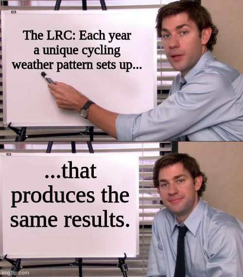
With a new LRC setting up soon, I once joked with Gary Lezak on the old KSHB weather blog about this and he laughed and pretty much agreed. All in fun.
-
September 2023 Observations and Discussion
mlgamer replied to hawkstwelve's topic in East of the Rockies
Topeka has officially received only 0.30" of rain for Sept and is running a -1.76" deficit for the month after an already very dry meteorological summer. The models are backing off any beneficial rain for the short term anyway though still some hope for the end of the week. We just can't buy a decent rain around here. -
I'd settle for rain all winter with no snow if that's what it would take to get some moisture here. The cracks in the ground around the area are among the biggest I've ever seen. Soil has been pulling away from foundations, sidewalks, and driveways all summer so it's been lots of watering. Most yards are pretty much brown except for those being watered. Hope a change comes soon.
-
If that verifies I will be impressed for sure...lol. Stranger things have happened so who knows...
-
I thought this image was a meme when I first saw it. Is this for real?
-
Forbes now has temp 100, dewpt 82 and HI 126. Looks like Lawrence might hit HI 130 soon. How fun...lol!
-
Current readings at Forbes Field near me: temp 98; dewpoint 80; heat index 118. Summer ain't playin'...lol
-
Greetings everyone! The heat really gets cranked up today...my forecast high is 108. Heat waves. Yuck. Interesting AFD from TOP this morning. Excerpt: "Well, today`s the day. The much advertised heat wave will begin today as ridging strengthens and builds north across the Central Plains. According to RAP mesoanalysis, 850 mb temperatures are already at 30C. Looking at a climatology of TOP`s upper air soundings, 30C temperatures at 850 mb have only been observed three times since soundings began in 1955, with a maximum of 31 C in June 1980. So we are in very rare air indeed. The main question for today continues to be how deep the mixing will be. If those very hot temperatures aloft can fully mix out, we`ll be looking at temperatures in the 110 to 115 degree range, which would be pushing all time records. A more reasonable mixing scenario would see highs today in the 105 to 110 range, which would still be near daily record maximums.
-
Winter 22-23 Fun Facts for Topeka! Greatest snowfall: 1.5" (Dec 22) Last snowfall 1" or greater: 1.1" (Jan 24/25) Total snow since January 26: 0.6" (See my sig line for more gory details...)
-
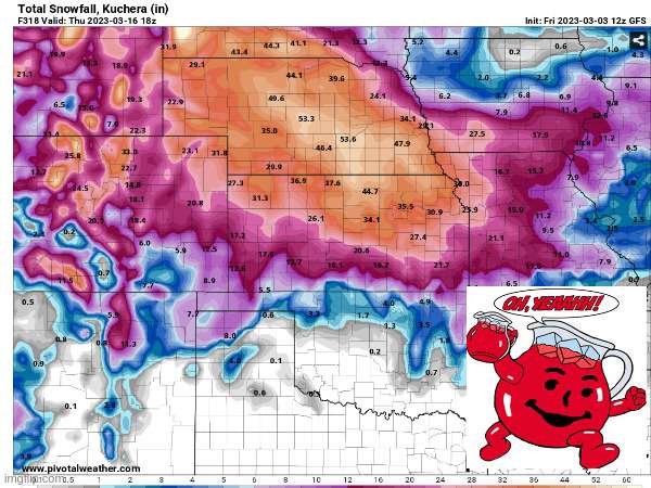
The above chart ignores any snow that fell before December (and so far in March). For the entire winter Topeka is running at 36.7% of normal to date (5.8/15.8) and would not be over 50% even for that time period (meteorological winter). The point is the disparities for the entire season are actually worse than shown for some areas. ETA: purple chart posted by @Tom.
-
Yep. Models have already locked onto what we have seen all winter. Just more of the same.
-
18z GFS has 0" of snow for me at 240 hrs after the 12z run had 30.9". That's pretty crazy even for the GFS...lol
-
-
12z 12km NAM and 09z SREF both took big steps backwards for me. Not like it was a surprise or anything.
-
This storm also has also got the attention of the Topeka NWS but they are remaining cautious about it. Obviously, thermals are the big question along with the exact track. I doubt we get a big dump of snow here, but stranger things have happened.
-
As we move into March, Topeka is sitting at it's 3rd least snowiest winter over the past 25 years. Of course, that could change before the end of the season. Five least snowiest winters in Topeka over the last 25 years: 11-12: 3.1" 15-16: 4.9" 22-23: 5.8" 16-17: 6.6" 17-18: 8.1" (Also note that this list of five includes three consecutive winters: 15-16, 16-17, 17-18)
-
February 2023 Observations and Discussions
mlgamer replied to Iceresistance's topic in East of the Rockies
Well, so much for February being our snowiest month of the year here in Topeka. We'll end up with only 0.6" of snow this month. Couldn't even manage an inch. -
Clinton, I'm thinking this is the Nov 26th system using the LRC...right? If so, it makes sense this would just miss me to the southeast and put you in a fairly good place. GFS/Euro 500mb forecast maps match up pretty well with Nov26/27 (roughly 97/98 days or so).
-
February 2023 Observations and Discussions
mlgamer replied to Iceresistance's topic in East of the Rockies
I made a trip from Olathe to Topeka earlier this evening that took about an hour and 45 minutes instead of the normal hour. K-10 was awful with most overpasses ice covered from Olathe to Lawrence. Yep, not a fun drive for sure. -
February 2023 Observations and Discussions
mlgamer replied to Iceresistance's topic in East of the Rockies
Even TOP has mentioned this system in this afternoon's (2/16) AFD. I bet we get a storm thread started for this fairly soon. "...By the middle of next week, a more interesting pattern begins to take place as much colder air builds over the Northern Plains and a deep upper trough digs into the western US. Low pressure should eventually developing in the lee of the Rockies and sweep northeast across the Plains, with the eventual impacts to our area depending on the track and strength of the low. Given current ensemble probabilities, we seem more likely to stay on the warm side of the system, but there`s plenty of time to allow these details to come into focus." -
February 2023 Observations and Discussions
mlgamer replied to Iceresistance's topic in East of the Rockies
This describes about the last ten winters here in Topeka...you'd think just by dumb luck we might be in the right place once in a while...but nope. -
Continue to have brief waves of mostly graupel passing through this evening. The latest batch was nearly pea size and almost sounded like small hail hitting the house. Don't really see this too often. I'd rather have the near blizzard conditions but oh well...lol. Temp is 31F. ETA: Just had a loud clap of thunder to go with all of this! Rockin' and rollin' out there...lol
-
Have graupel falling and turning the deck white. The models have hinted at mixed precip here but seems to be a bit early. Probably doesn't mean anything overall but interesting nonetheless. Temp is 36F.
-
Down here on the southern edge my grid forecast got cut in half from 2-4" down to 1-2". Looks like dry air among other problems is going to win the day here.


