Beltrami Island
-
Posts
368 -
Joined
-
Last visited
Everything posted by Beltrami Island
-
March 2021 Observations and Discussion
Beltrami Island replied to Tom's topic in East of the Rockies
How are there data points clearly well into March on this chart? Doesn't make any sense. -
February 2021 Observations and Discussion
Beltrami Island replied to Hawkeye's topic in East of the Rockies
This will help out for a few days, but I would expect plenty of red flag warnings in the Dakotas over the next few weeks given the lack of snow there this winter. They entered winter with drought conditions as it is. -
February 2021 Observations and Discussion
Beltrami Island replied to Hawkeye's topic in East of the Rockies
Sledding season is pretty much done here after 39 and 44 the last couple days. There just wasnt enough base to withstand the warm temps. My sled hasn't moved since mlk weekend when I decided there really wasn't enough snow to make it worth riding until we get more snow..... it never happened. If you blindly gave me a summary of temps, precip, and snow for my area since October 1, I would say with strong confidence that we must be in a moderate to strong el nino, go figure. -
February 2021 Observations and Discussion
Beltrami Island replied to Hawkeye's topic in East of the Rockies
We (northern minnesota) did not have any impact from the low that affected you guys down south yesterday, I had all sun and only dropped to 30 overnight. There is a massive sub 980mb pacific low going across canada dragging pacific air across the Canadian prairies, warmed even more by the chinooks coming down from the Canadian Rockies. -
High temps early November were 50s, 60s, and even a few 70s up here. Any snow/ice from October was long gone after that.
-
That 63.5 for Duluth is quite deceiving if trying to analyze this winter Dec 1 onward. It includes 31.2 that fell in October (12.0) and November (19.2).
-
Near as I can figure from online sources, my location has failed to reach a 12" snow depth at any time during met winter in the following years winters since 1988 : 2015-16 2011-12 2006-07 2002-03 2001-02 1999-00 1997-98 And joining the list soon....2020-2021? Unless something changes drastically in the next 13 days. It's going to take at least 4-6+" inches of snowfall to do it and the forecast and models don't give much realistic hope. I had a hunch it was a bad sign entering winter with drought conditions developing throughout the late summer and fall (similar to 2011-12) Despite the warmth of December and January, my latitude allows for snow retention through some major positive temp anomalies in Dec and Jan. There just hasn't been any moisture. If the dryness continues through spring it's going to be a heck of a spring fire season around here. I know back in late winter 2015-16 the mn dnr was running extra fire training in anticipation of a bad fire season due to lack of snow. Luckily there was a wet 10" snowfall the third week of March that kept the ground wet enough until green up. The 2011-12 mid March torch was followed by a cool and wet period in late March here that knocked fire danger down until things greened up in April.
-
Spring has sprung up here. Above 0 felt warm today. Can go to my light jacket starting tomorrow afternoon.
- 327 replies
-
- 4
-

-

-
- 2/6-2/9
- polar vortex
- (and 1 more)
-
The average windiest locations of interior North Americas that are the prime areas for wind power development also have a flaw in that the highest demand for energy in the same areas occurs during the calmest winds, extreme heat and cold. This is a widely known but poorly addressed weakness of wind power.
-
I have a coworker who lived an hour south of Fairbanks, said the worst cold was the strong south winds during warmups from -40 to 0.
- 327 replies
-
- 2
-
-
- 2/6-2/9
- polar vortex
- (and 1 more)
-
Calm winds and dry air, add some sun and it can feel deceptively less cold than it actually is at -30, for a short time.
- 327 replies
-
- 2
-
-
- 2/6-2/9
- polar vortex
- (and 1 more)
-
Missed this from yesterday. If you want to find the middle of nowhere, you are not far from it at Norris Camp
- 327 replies
-
- 5
-
-
- 2/6-2/9
- polar vortex
- (and 1 more)
-
Good prediction grizzcoat. At least one prelim -50. Would not be surprised to see a few more from this am. It's funny how ifalls has the reputation of icebox of the nation but there are actually much better locations for radiational cooling than where the airport is. Ifalls airport is a big flat area that's relatively open without much tall trees to block wind and allow the cold air to sink down. As opposed to the infamous Embarras area that sits in a low swamp surrounded by heavily forrester higher terrain that allows the dense cold air to sink into it.
- 327 replies
-
- 6
-
-
- 2/6-2/9
- polar vortex
- (and 1 more)
-
-36f this morning, coldest yet this arctic outbreak. It was eerily calm out and actually pretty comfortable to be outside for brief times. If you have ever had a bad chest cold and start coughing just from taking a deep breath. That is what breathing in deep at -30 or colder feels like when you first step outside.
- 327 replies
-
- 4
-
-

-
- 2/6-2/9
- polar vortex
- (and 1 more)
-
Most arctic air cold spells here in northern minnesota end with the coldest temps in the calm of the high pressure center the morning before it moves south and east. The result is a return flow from the south over the next 36-48 hours that can warm temps 30-40-50 degrees in some cases. The classic example is Feb 1996 when Tower MN set the state record low of -60. Within a few days it was in the +40s for a temperature difference around 100 degrees.
- 327 replies
-
- 6
-
-
- 2/6-2/9
- polar vortex
- (and 1 more)
-
Had -34 of the car yesterday morning. Saw International Falls got down to -38 officially at the same time. Pleasantly surprised to wake up today to light winds and only a low of -19 thanks to a deck of clouds overnight.
- 327 replies
-
- 1
-
-
- 2/6-2/9
- polar vortex
- (and 1 more)
-
Ironically, even though it accounts for the bare ground over the dakotas pretty well. It treats lake winnepig as open water, moderating temps over it, even though the lake is long frozen over.
- 327 replies
-
- 2
-
-
- 2/6-2/9
- polar vortex
- (and 1 more)
-
I think -30 is about the floor for temps until the winds calm down for me. The sun has warmed my home thermometer to -7.
- 327 replies
-
- 1
-
-
- 2/6-2/9
- polar vortex
- (and 1 more)
-
Yes, Full sun! Makes such a difference and what makes Feb arctic air so much more tolerable than Nov-Mid January when it doesn't get fully light til 9am and by 3pm the shadows are already long. Sun today was fully up by 8am and stays light til 4:30pm before the shadows get long.
-
I went below 0 a few hours ago. My nws point forecast doesn't get back to 0 until next Friday. It doesn't look like any extreme over night lows thanks to the wind. But I would take a calm -40 over a windy -20f. In fact the coldest feeling stretch of weather I can recall was actually mid December 2013 where the wind howled for days but the temp never dropped below -20.
- 327 replies
-
- 3
-
-
- 2/6-2/9
- polar vortex
- (and 1 more)
-
February 2021 Observations and Discussion
Beltrami Island replied to Hawkeye's topic in East of the Rockies
Bizarre? Have you seen the 12z Canadian? Now that is a different solution. Splits next weeks storm west of the rockies. Turns one part into a clipper the other down to Baja as a cutoff. Who knows, maybe the Euro will match this? -
January 2021 Observations and Discussion
Beltrami Island replied to Grizzcoat's topic in East of the Rockies
This winter is starting to remind me of the late 90s and first half of the 00s here. After the historic winters of 95-96 and 96-97, there was a real void of winter snow for northern minnesota and north dakota. There were sping and fall snowstorms but nothing of note for Thanksging-Mid March, every snowstorm forecast hyped up just seemed to fizzle out or miss the region. -
January 2021 Observations and Discussion
Beltrami Island replied to Grizzcoat's topic in East of the Rockies
-27 so far this morning officially for KBDE. Maybe eek out a -28 or -29 for the next couple hourly temps before sun fully rises. Car temp said -31. Wind Chill warning is a bit ironic here today, wind is 0 and not much forecast the whole day. -
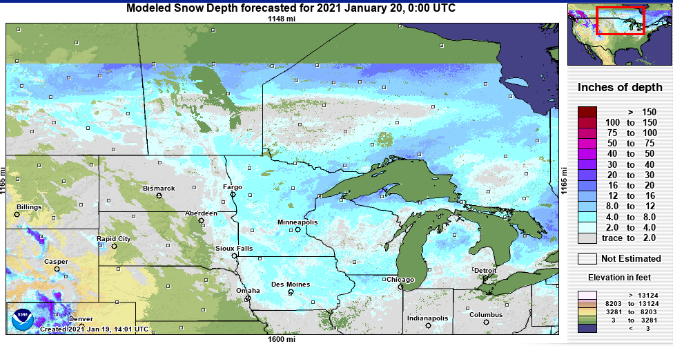
Unlike many here who just want big snow events. I want deep snowpack, I don't care if its 10 small clippers or 1 big Colorado low! I have found these maps from the MN DNR to be the most accurate available and are published every Thursday during the late fall to early spring. They have maps online going back to 1996-97. Looking back through them it seems like even though El Nino winters may bring warm temps they do eventually bring snow, even 2015-16 and 1997-98 to some degree. But, when La Nina winters go bad, they really go bad! 2011-2012, 1998-99, 1999-2000 as examples. This winter is just a small notch above those examples so far. Sitting at the the 20th percentile snow depth for the date as of yesterday.
-
January 20 and barely any snow on the ground in southern manitoba and northwest ontario. Some spots in northwest ontario with bare ground!