

FV-Mike
-
Posts
633 -
Joined
-
Last visited
Everything posted by FV-Mike
-
Excited for N IL first bigger storm of the year. Neb and S IA looks golden. Interesting note from LOT on ratios in this morning afd Forecast soundings indicate a bit better spatiotemporal overlap of the deeper ascent within the DGZ on Monday afternoon/evening than previous iterations. The result was a jump in Cobb ratio output towards 13-15:1. At the same time, though, thermal profiles will still be rather warm, with a deep saturated layer hugging -1 to -8 C which tends to support a larger degree of riming which would cut down on ratios. Did nudge our ratios up a smidge for Monday afternoon/evening closer to 11-12:1
-
LOT's afternoon AFD starting to get me excited. Here is a little portion. The main message we`d like to convey is that while there is uncertainty inherent to this particular forecast and generally all winter system forecasts at this time range, confidence continues to increase in a potential winter storm impacting the area. This includes an increasing chance for a swath of several inches of snow, with distinct potential for 6"+ of snow, and certainly not out of the realm for well over 6" if ingredients come together to support heavy mesoscale f-gen driven banding, considering that well above normal moisture content (unseasonably high PWAT/mixing ratios for a winter system). Snow forecast was leaned toward the thus far quite consistent ECMWF suite and also accounted for a large northward jump in the 12z GEFS mean and many of its members. Regarding our snowfall forecast, we feel that the chance that our entire CWA is missed by moderate to significant snowfall amounts is decreasing. That said, there are multiple competing factors to this forecast, with subtle changes of key players ultimately modulating where the highest snowfall amounts occur in a north to south range and peak snowfall amounts. Our current thinking regarding the broader area in which narrower east to west banding is liable to set up with several to 6+" of snow is fairly close in line with WPC`s Day 4 Snow/Sleet outlook and placement of 30-50% and 50-70% contours, which will help drive our snow forecast message.
-
DMX thoughts on the bigger system. Some light wintry precip may linger into Sunday, but then the atmosphere quickly reloads as a lead shortwave ejects from the mean western conus trough. There remains significant differences between the latest deterministic Euro and GFS both in track and intensity. GEFS mean leans more toward the more northerly and robust Euro. PoPs were boosted above the NBM output for Sunday night into Monday across southern into central Iowa to reflect increasing confidence in another round of snow moving through. The significant model spread hinders confidence in possible snowfall amounts, but moderate to heavy snow is not out of the question.
-
Nice to see areas in the GL that have been missed in the range for this storm
-
January 2021 Observations and Discussion
FV-Mike replied to Grizzcoat's topic in East of the Rockies
Maybe a couple on inches for us N IL folks from Saturday through Sunday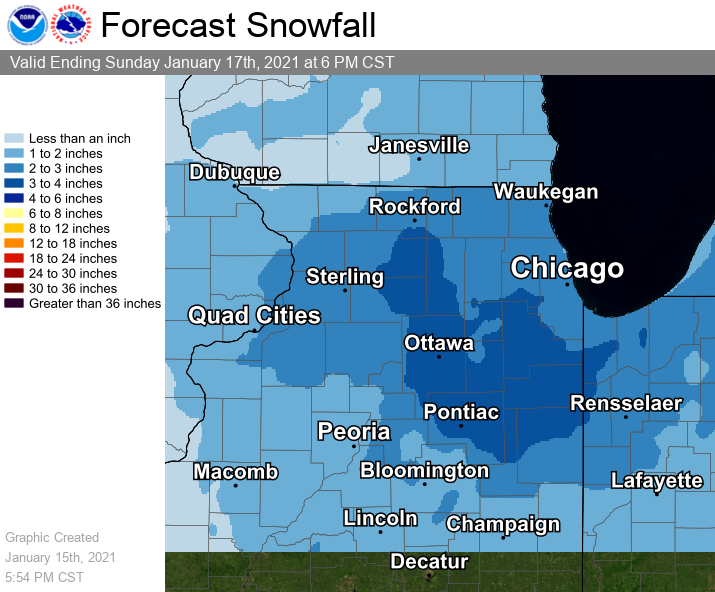
-
Wasn't expecting much for the CHI area but LOT's update is saying its warmer than expected. Snow trends have changed slightly for this present system. Observations and initial soundings show a warmer atmosphere than originally indicated, and model soundings continue this trend. We have bumped our surface temperatures upward somewhat to reflect these slightly warmer conditions. With warmer temperatures in our column and at the surface, the transition from rain to snow will occur later, and confidence that some areas further southeast will turn to snow at all is not high. With these changes, expected snow accumulations are lower, and primarily limited to our northwestern counties, with up to 1 to 1.5 inches the expected amounts. Future messaging will reflect these changes, which will also include the likelihood that impacts are minimal to the commute for most of if not the entire area.
-
January 2021 Observations and Discussion
FV-Mike replied to Grizzcoat's topic in East of the Rockies
Pretty detailed thoughts from LOT for the long range. Looking beyond day 7, pattern across north America continues to appear on very consistent run to run trends of ensemble forecasts that it will become more favorable for more sizable precipitation and snow producers. Driving force will be a spiking poleward ridge in the vicinity of Alaska (negative East Pacific Oscillation (-EPO)), downstream troughing onto the west coast (negative Pacific North American pattern (-PNA)), and quite notably, a very impressive signal for a deeply negative North Atlantic Oscillation (-NAO), marked by closed contour ridging over southern Greenland on the ensemble means. Typically, strong negative height anomalies onto the west coast portend milder Pacific driven patterns. However, in this case, should medium range guidance be on the right track, the high amplitude ridging to and north of Alaska will set up cross polar flow into our source region and the -NAO would act as a roadblock from systems cutting very far north. So, in sum, the relatively active pattern over the next several days could become quite active with more regular plowable snow threats at least through the end of January. -
January 2021 Observations and Discussion
FV-Mike replied to Grizzcoat's topic in East of the Rockies
Accuweather going all in for the late Jan cold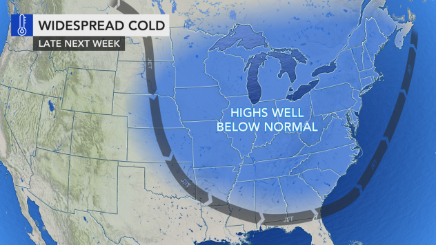
-
Been under a heavy band fo last 30 mins. Best snow of the day so far. Think we get to 2 inches out here
-
went sledding with the kids. Good sized flakes coming down now. Hoping for 2-3 inches by the end of the day
-
visibility dropped quickly. grass is almost covered
-
My county, Kane (IL), added to WSW. nice suprise
-
Have a friend flying from O'hare to DSM today at 2:30. Flight is still on. I told him this morning there was no way it would be getting out
-
Wow NAM now looks like the Canadian.
-
I like what the HRRR is showing. Anything to end the rut the Chicago area and points east.
-
DECEMBER 23-26 Potential storm for SW Great Lakes
FV-Mike replied to kush61's topic in East of the Rockies
LOT leaning towards the Euro the ECMWF and CMC global have favored the southern energy rounding the trough to help with a modestly deepening surface low in the frontal trough much closer to our latitude. This sort of setup would slow down the cold air mass by several hours, but more importantly allow for the blossoming of cold sector precip on the 700 mb trough axis. With overall a bit better operational and ensemble support for this idea, including roughly half of ECMWF ensemble members and an uptick in support from the GEFS, have similarly to previous shift trended the grids in favor of this. Should subsequent trends continue down this general path, at least some snow accumulation would be possible later Wednesday night into Thursday morning in the deformation axis. -
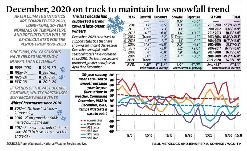
Tom Skilling posted this over the weekend. Shows the lack of snow for the Chi area in December over the last 10 years. Also of note is how the total seasonal snowfall ended.
-
Got no snow here but it looked great on TV during the Hawkeye game! Go Hawks!
-
Nice looking storm. Hoping this bumps a little SE. Happy with a couple inches
-
Starting to get interesting around the 12th
-
32 degrees while a small band is pushing through Chi suburbs. Grass and cars starting to get covered
-
2/24-2/26 Snow (Ring the doorbell so the big dog wakes up!!!)
FV-Mike replied to Madtown's topic in East of the Rockies
Snowing harder here than I anticipated. Grass is lightly covered -
2/24-2/26 Snow (Ring the doorbell so the big dog wakes up!!!)
FV-Mike replied to Madtown's topic in East of the Rockies
Still think 3-6 is a good bet. Not sure if your trolling though...…. -
2/24-2/26 Snow (Ring the doorbell so the big dog wakes up!!!)
FV-Mike replied to Madtown's topic in East of the Rockies
Skilling's FB update moments ago A little geek stuff now---so fair warning, tune this out if this sort of material is not your "cup of tea". 45 model forecasts have been analyzed for this prediction and model generated snowfalls among them centered on the city ranging from as little as 3.4" to as much as 16.6". Either of these two totals sits at the most extreme ends of extrem the forecast spectrum. These have a lower likelihood of actually occurrin--but should either of them actually occur, totals like these are likely to impact a limited portion of the Chicago area. If one averages all 45 snow forecasts centered on Chicago, the total which emerges is roughly 9". Taking this figure and the accumulation estimates which sit in the middle of the pack as well as other variables we weather types look over, a predicted snowfall range of 6 to 12" range makes the most sense at this time. I'm posting a set of varied model snowfall forecasts for you to check out yourself. It is always fascinating to watch how complex situations like the one coming together is handled by these incredibly sophisticated models. What's been interesting--and I noted it in my posts Sunday--is how the the axis of heaviest snowfall as predicted by has been sinking southward. It started yesterday in southern Wisconsin-----it's now down across the Chicago area. Interestingly, the vaunted European Center model and its ensembles place the axis of heaviest snowfall just south of Chicago--still producing a respectable 7-8" snowfall city with as 4.5" near the Cook County/Lake county, IL line and totals as high as 11" on the Indiana line and into Lake CiLke County, IN. It's also interesting that our 4km RPM model is producing a snowfall in the 6" range through the heart of the city building to 10" toward the Illinois/Indiana line at Lake County, N. The suggesting of both these models as well as the UK Met center's models is that accumulation tallies will ease heading north into northern counties an toward the Wisconsin line and just north where 3-4" would be most common. I'll keep your posted on updates as this winter storm and new data important to it and its impact come in.. -
2/24-2/26 Snow (Ring the doorbell so the big dog wakes up!!!)
FV-Mike replied to Madtown's topic in East of the Rockies
LOT keeping with the northern track but Skilling has mentioned numerous south runs. Quote from his FB Page " Southward shifting model guidance on potentially significant snow accumulations in that time frame, as covered in our earlier discussion, suggests other sections of the Chicago area may need to be included in future WINTER STORM WATCH issuances should that forecast trend continue. Stay tuned!"


