


Timmy Supercell
-
Posts
7757 -
Joined
-
Last visited
-
Days Won
14
Everything posted by Timmy Supercell
-
That's correct, but I still had a dimness in K-Falls.
-
Got a little dim here for about a half hour as well. Not dark enough to trigger street lights but it reminded me of the Aug 2017 eclipse in Oregon.
-
-
I think anomalies in general are greater in colder climates, I saw examples of really large ones in Klamath Falls though they were almost exclusively in certain times of the year. I remember being surprised Nov 2016 wasn't in the top warm ones in that town after finding it ended up with a rather large spread from normal. So, in that case, what would classify it as a climate breaking statistic? Need more info for sure.
-
My first one wasn't so bad, and our early Fall was a nicer transition off of summer than last year. There can be worse places for summer weather too
-
Any idea how this summer might start and end? I want to ease into it and not have 90's in June this year. and then not still have 90's all September..
-

March 2024 Observations and Discussion
Timmy Supercell replied to Tom's topic in East of the Rockies
Thankfully my storm was a late morning MCS, and we had a rare 'moderate risk' on SPC for the area, I'm sure many locals saw it coming even if they were at work or doing whatever else. Turns out nobody got injured, but many homes received varying amounts of damage. They expected the evening round to be a more dangerous outbreak, but our 1st round ended up being one large tornadic complex. Many cities were in Tornado Warnings both before and after my county. So I think it would've hurt more people if it had happened out of nowhere.. just a theory though. -
April 2024 Observations and Discussion
Timmy Supercell replied to westMJim's topic in East of the Rockies
This could be a while before they have the whole scope on what Tuesday did in the Tri-State area. https://www.wsaz.com/2024/04/06/nws-confirms-9th-tornado-tri-state/?fbclid=IwAR3q2NPvXnX3m4hBDy78xbGdEgRf2h8F97S-yez0he4VL1ua0lFIj6erj0s_aem_AYufZl_ot2UQkxBBv2Y5PZMQUwL4DO6MlAI84mi6JRbeFMbX4EYNB-FSRZsbI9sKZo6xSC6GaNak3rjqEUD4Sk75 -
March 2024 Observations and Discussion
Timmy Supercell replied to Tom's topic in East of the Rockies
We had a huge one on Tuesday. Ashland just barely missed a tornado and my county had 2 of them from the same storm.. NWS Charleston is in fact still confirming additional tornadic damage in various locations. -
School wasn't in session during the last one.
-
April 2024 Observations and Discussion
Timmy Supercell replied to westMJim's topic in East of the Rockies
Right now would be a great time for the solar eclipse. Not a speck of cloud in the sky here. Wunderground says mostly cloudy 4/8 and there will be some more rain and t'storm chances off and on coming up again. -
The Total Solar Eclipse of April 8, 2024
Timmy Supercell replied to Hoosier's topic in East of the Rockies
Are we still on track to calling this the Total Over Cast of April 8 2024? -
March 31st - April 2nd Potent Plains Storm
Timmy Supercell replied to Clinton's topic in East of the Rockies
Just found this posted by NWS Charleston on facebook. Apparently one of the Boyd County touchdowns was an EF2. The EF1 was pretty close to Ashland.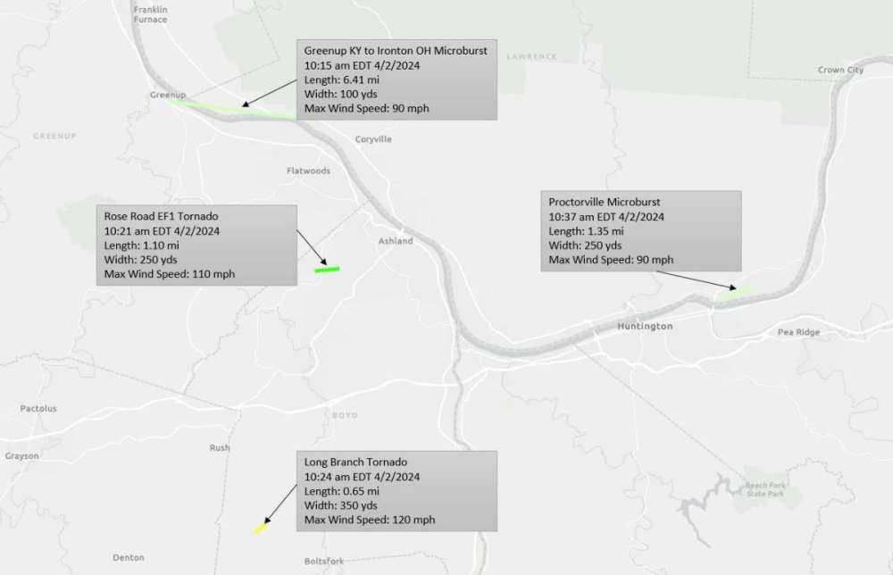
-
April 2024 Observations and Discussion
Timmy Supercell replied to westMJim's topic in East of the Rockies
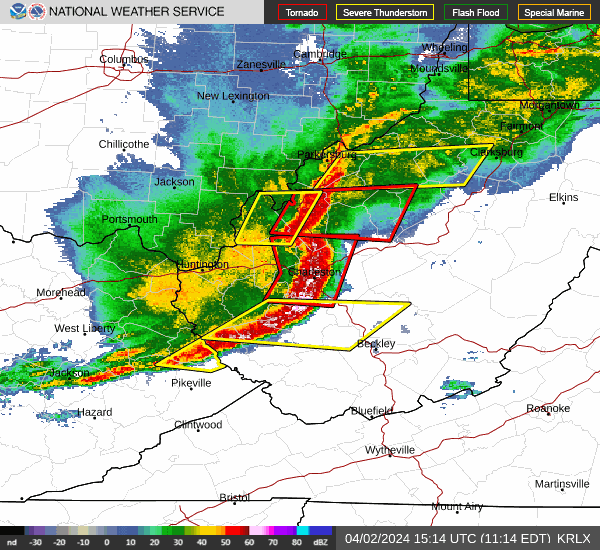
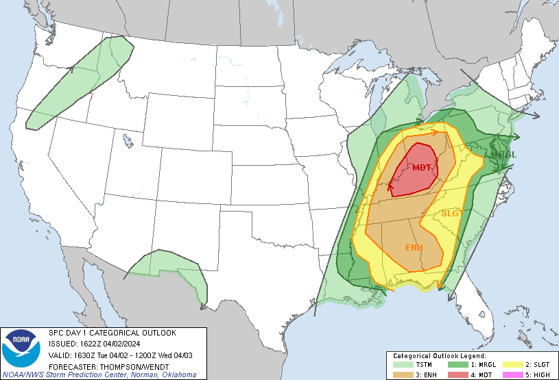
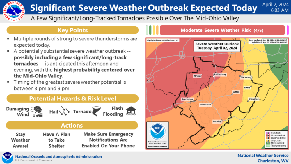
A couple things I was able to save around the time I couldn't use my computer.. There were more TOR's being issued after that first loop. Sirens were sounding in Ashland from 10:15 to 10:30 I think. TOR's continued being dished out in WV. It formed a well defined bow echo after passing through the Ohio River. The SPC then expands the Moderate Risk boundary when it started clearing but I think the evening round was a tad watered down. Even though it sounded like supercells did happen in eastern KY with more tornado watches and warnings in spots. But they didn't appear quite as long lived as modeled. Moderates are super rare at my location. Western KY has been in a couple since I moved here but not this area.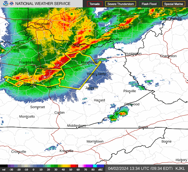
-
April 2024 Observations and Discussion
Timmy Supercell replied to westMJim's topic in East of the Rockies
Just got my internet restored! Hmm.. temperature unknown but feels like 45-50 (and breezy). Ashland airport got knocked, their last observation was 10:10am yesterday, about the time that MCS struck. -
For future reference I'm a block over from Central Park in downtown. There is a big King's Daughters Hospital by that park too.
-
March 31st - April 2nd Potent Plains Storm
Timmy Supercell replied to Clinton's topic in East of the Rockies
Skimming through SPC reports from yesterday, someone in Cannonsburg (Boyd Co.) measured a 102 mph gust on their Davis wx station! That first storm was definitely stronger than originally thought. -
March 31st - April 2nd Potent Plains Storm
Timmy Supercell replied to Clinton's topic in East of the Rockies
Ironton had a tornado and we've driven there a few times, it's just after one of the bridges out of Ashland. -
March 31st - April 2nd Potent Plains Storm
Timmy Supercell replied to Clinton's topic in East of the Rockies
Yeah my house had somewhere between 60 to 70. Thankfully my street didn't get anything knocked down. I'm fine for those wondering. I'm waiting for our internet to return. Other than a few power bumps I we got lucky. About 15000 people lost power in the area. Nearby locations had confirmed tornado touchdowns, up to EF1 damage. -
The day played out differently than they expected. That first MCS turned out to produce the widest swath of reports and damage. Looked like it also bowed out in West Virginia? One source called it a derecho like storm but not sure if it actually was one.
-
Ashland had the outflow winds and scattered outages/trees down but I don't think this town had a tornado. I have power but most of Ashland reportedly doesn't have internet. Been stuck using a potato Android phone for all of my information. It was a big storm. Couldn't make out a lot of structure but it looked like some kind of wall cloud may have formed. But shelf wasn't very clearly there. Video was hard to get and it's a good thing I wasn't standing on our deck because a few objects did fly by right where I would've stood.. Lol
-
March 31st - April 2nd Potent Plains Storm
Timmy Supercell replied to Clinton's topic in East of the Rockies
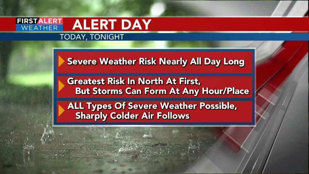
Already warming up and its only been light for an hour. 69, and a MCS is approaching! There was a low of 58 at the airport but it must've lasted 5 minutes. Well here we are! They're holding onto the Moderate Risk. Even if my county escapes tornadoes today, I think I will still end up with power outages and some hail out of this.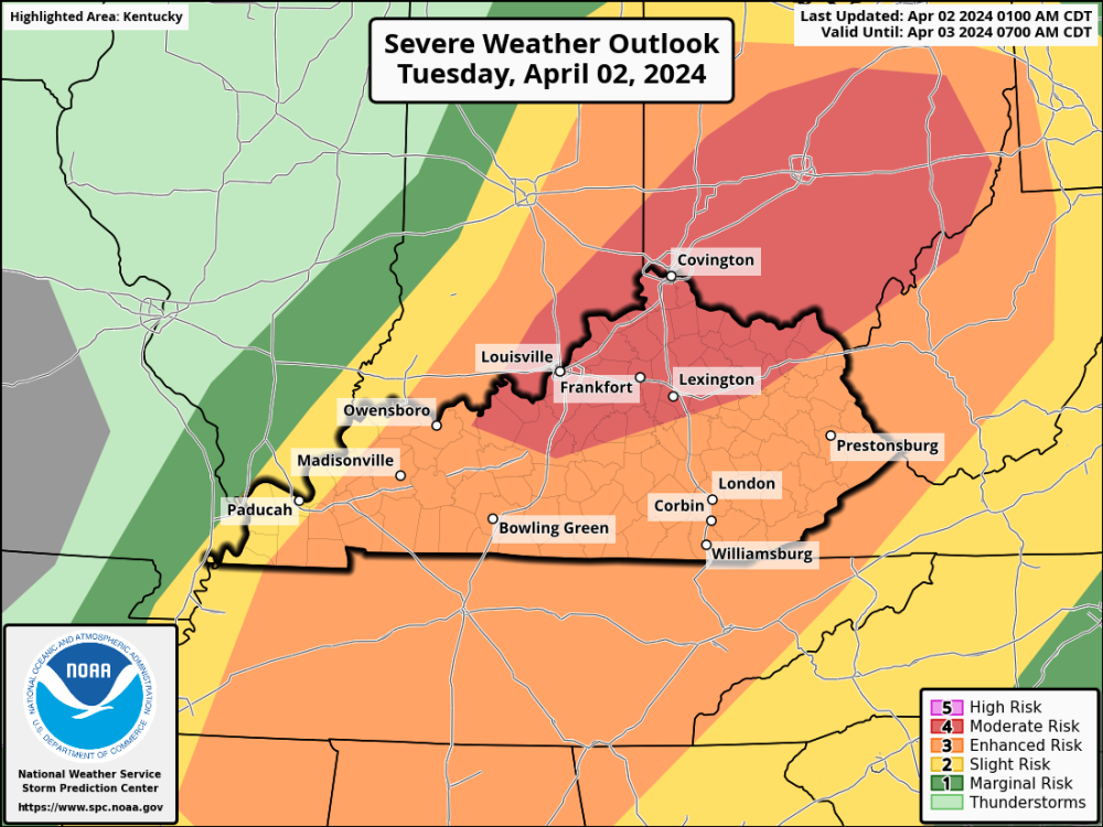
-
March 31st - April 2nd Potent Plains Storm
Timmy Supercell replied to Clinton's topic in East of the Rockies
Another cooldown on the way after the storms, even some nighttime snow.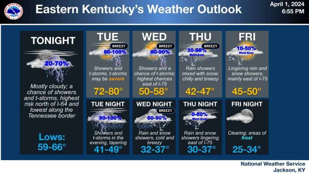

-
March 31st - April 2nd Potent Plains Storm
Timmy Supercell replied to Clinton's topic in East of the Rockies
At first I thought the Tuesday evening storms were supposed to weaken coming off tonight's activity. That Moderate in Ohio concerns late Tuesday storms.. so looking at 2 decent outbreaks of supercells potentially. -
March 31st - April 2nd Potent Plains Storm
Timmy Supercell replied to Clinton's topic in East of the Rockies
70 and sun is out finally. There should be plenty of time to energize this region for the incoming MCS that develops tonight.


