-
Who's Online 11 Members, 1 Anonymous, 151 Guests (See full list)
-
Activity Stream
-
6995
January 2026 PNW thread
Just hit 4”, added 1” in the last 25mins. Rates spiking like crazy just ahead of the mix line. Even the beltway is blanketed in snow right now. And yeah this glacier is probably here to stay for the rest of winter, our last major sleet storm on Valentine’s Day 2007 dropped 4-5” of sleet and it stayed around for 6 weeks, well into March. And this time it’s earlier in the season with even colder temperatures. Just need to avoid a ZR fest, if we go that route it’s going to be a headache with temps so cold. -
1209
January 2026 Obeservations & Discussions
I will start off that new record lows were set at Grand Rapids -19° that tied the low in 1948, Kalamazoo -18, Battle Creek -18° and Muskegon with -7°. It was the coldest it has been here in grand Rapids since January 19th, 1994, when the temperature dropped to a -22°. In the area I had one friend who texted me with a temperature of -22 last this morning. The coldest reading I can find in Michigan was a -31° at Cadillac. Yesterday’s high of 5 was the coldest high for any January 24th at Grand Rapids. We will completely miss the big snowstorm to our southeast and will end up with no new snow here in Grand Rapids. KEY MESSAGES SNOW IN SOUTHERN MICHIGAN TODAY LAKE EFFECT SNOW SHOWERS MONDAY ADDITIONAL SNOW ACCUMULATION AND BREEZY TUESDA Detailed Forecast Overnight A 40 percent chance of snow. Cloudy, with a low around 3. Wind chill values as low as -8. East northeast wind around 6 mph. Sunday A 50 percent chance of snow. Cloudy, with a high near 14. Wind chill values as low as -8. North wind 6 to 8 mph. Sunday Night A 20 percent chance of snow showers before 10pm. Cloudy, then gradually becoming partly cloudy, with a low around 2. Wind chill values as low as -9. North wind around 6 mph. Monday A 30 percent chance of snow showers, mainly before 1pm. Mostly cloudy, with a high near 15. Wind chill values as low as -8. Northwest wind 6 to 11 mph, with gusts as high as 22 mph. Monday Night Snow likely after 1am. Mostly cloudy, with a low around 8. Southwest wind 8 to 14 mph, with gusts as high as 24 mph. Chance of precipitation is 70%. New snow accumulation of around an inch possible. Tuesday Snow showers, mainly before 1pm. High near 18. Chance of precipitation is 90%. New snow accumulation of around an inch possible. Tuesday Night A 30 percent chance of snow showers before 1am. Mostly cloudy, with a low around 5. Wednesday Snow showers likely. Mostly cloudy, with a high near 17. Wednesday Night A chance of snow showers. Mostly cloudy, with a low around 0. Thursday A chance of snow showers. Partly sunny, with a high near 16. Thursday Night A chance of snow showers. Partly cloudy, with a low around -2. Friday A chance of snow showers. Mostly sunny, with a high near 18. Friday Night A chance of snow showers. Mostly cloudy, with a low around 4. Saturday A chance of snow showers. Mostly sunny, with a high near 21. The official H/L yesterday at Grand Rapids was 5/-19 both records. There was a reported trace of snowfall and a reported 9” of snow on the ground I have 12” here in my yard. For today the average H/L is 30/17 the record high of 66 was in 1950 the coldest high of 7 was in 1969 the record low of -14 was in 1961 the warmest low of 42 was in 1916. The wettest was 0.72” in 1990 the most snowfall of 8.4” was in 1964 the most on the ground was 19” in 1979 and 1963. Some weather history for January 25th 1987 The second major storm in three days hit the Eastern Seaboard producing up to 15 inches of snow in Virginia, Maryland and Delaware. Up to 30 inches of snow covered the ground in Virginia following the two storms. (National Weather Summary) (Storm Data) and in 1990 Low pressure developed explosively over east central Missouri and moved into Lower Michigan producing high winds and heavy snow across parts of Iowa, Illinois and Wisconsin. Wind gusts to 60 mph and up to a foot of snow created near blizzard conditions in southeastern Wisconsin and northern Illinois. Wind gusts in Indiana reached 76 mph at Wabash. Thunderstorms associated with the storm produced wind gusts to 54 mph at Fort Madison IA. (National Weather Summary) (Storm Data) -
6995
January 2026 PNW thread
How much on the ground there now? Hope you can hang onto a snow profile as long as possible. Though sleet will just contribute to your temporary glacier. -
-
1114
1/23 to 1/25 Major Winter Storm for Southern Plains
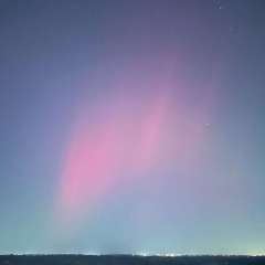
Found some color North of the boarder...- 1
-

-