-
Who's Online 10 Members, 0 Anonymous, 100 Guests (See full list)
-
Activity Stream
-
326
February 2026 Observations & Discussions
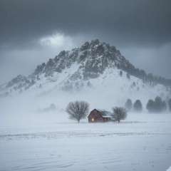
I would love to experience a snowstorm like this some day. 24" in 24 hours. That'd be so fun. -
326
February 2026 Observations & Discussions
I spent the the majority of the day out at the Waste Management Phoenix Open at the famous 16th Hole. It was a loud and action packed crowd and my 1st experience at any Golf tournament while doing it VIP style. All you can eat and drink and seeing some of the best golfers in the world. It was a bit too warm out in Full sun and light winds but we had plenty of shade in our booths. All in all, a great success and I certainly enjoyed all the "eye candy" out there as there were thousands of people that packed up all the areas. One of the people in our booth was from Michigan (Ann Arbor) and we briefly chatted about the winter and I immediately thought of @Nikoand the MI crew. He was a nice guy and definitely enjoying the 80's and sunshine. Scottie Scheffler was one of the highlights in the Colosseum style stadium (20,000 seats) and it really felt like you were in a stadium. -
326
February 2026 Observations & Discussions
Gosh, how lucky you've been in this NW Flow pattern as seemingly it just wants to snow in the same spots this season. Congrats! I just saw a video my sister sent me from the big fatties flying last night out her window. Nice little treat from Ol' Man Winter before the inevitable pull back this coming week. -
845
-
326
February 2026 Observations & Discussions
The snow that was in the forecast went to our SW so we ended up with no snowfall here in Grand Rapids. The temperature here in my yard held at 15 overnight and that is the current temperature here in my yard. The week ahead now looks to be mostly dry with just above average temperatures. There could be a chance of a rain/snow mix next weekend or even a chance of rain. We shall see how that plays out. KEY MESSAGES SNOW PASSES MAINLY SOUTHWEST OF FORECAST AREA THIS MORNI SNOW PASSES MAINLY NORTH OF AREA MONDAY NIGHT INCREASING PRECIPITATION CHANCES BY THIS WEEKEND Detailed Forecast Today Mostly cloudy, then gradually becoming sunny, with a high near 22. Calm wind becoming east southeast around 6 mph in the morning. Tonight Increasing clouds, with a low around 9. South southeast wind 3 to 5 mph. Monday Mostly cloudy, with a high near 30. South wind 5 to 7 mph. Monday Night Mostly cloudy, with a low around 26. South wind around 6 mph. Tuesday Partly sunny, with a high near 39. West northwest wind 6 to 10 mph, with gusts as high as 21 mph. Tuesday Night Partly cloudy, with a low around 22. Wednesday Mostly cloudy, with a high near 30. Wednesday Night Mostly cloudy, with a low around 15. Thursday Mostly cloudy, with a high near 31. Thursday Night Mostly cloudy, with a low around 16. Friday Mostly sunny, with a high near 32. Friday Night Mostly cloudy, with a low around 18. Saturday Partly sunny, with a high near 35. The official H/L yesterday at Grand Rapids was 21/13 there was a trace of snowfall there was 10” of snow on the ground. The highest wind speed was 24 MPH out of the N. For today the average H/L is 32/18 the record high of 60 was in 1925 the coldest high of 3 was in 1934 the record low of -12 was in 1974 the warmest low of 49 was in 1925. The wettest was 0.75” in 1900 the most snowfall of 5.4” was in 1952 the most snow on the ground was 23” in 2014. Some weather history for February 8th 1987 A powerful storm produced blizzard conditions in the Great Lakes Region. Winds gusted to 86 mph at Janesville WI and Cleveland OH received 12 inches of snow. North winds of 50 to 70 mph raised the water level of southern Lake Michigan two feet, and produced waves 12 to 18 feet high, causing seven million dollars damage along the Chicago area shoreline. It was the most damage caused by shoreline flooding and erosion in the history of the city of Chicago. (The National Weather Summary) (Storm Data) and in 2013 A nor'easter produced heavy snowfall over the New England states. In Boston, Massachusetts, total snowfall reached 24.9 inches, the fifth-highest total ever recorded in the city. New York City officially recorded 11.4 inches of snow at Central Park, and Portland, Maine, set a record of 31.9 inches. Hamden, Connecticut, recorded the highest snowfall of the storm at 40 inches.
-