
Leaderboard


Popular Content
Showing content with the highest reputation on 07/09/16 in all areas
-
I had a crazy thunderstorm this morning at 1-2am. At one point, within 2 minutes I had about 12 flashes. I had over 24 lightning flashes/strikes and lots of thunder this morning.5 points
-
I had .75" in a half an hour and probably over 100 lightning strikes.2 points
-
The NCEP GFS 850 anomaly is below normal for much of the PNW for most of the next 10 days still. SW BC and NW WA has -7F 850 T anomalies at times, parts of SE OR has around -10 to -12F anomalies at times. I wonder what July will finish off at.1 point
-
I clearly remember you said the Eastern half of the nation would fry this summer and the NW would be cool. You deserve credit.1 point
-
Holy crap! 6000 heights shown over the Midwest before day 10. That could be a deadly heatwave for them if it verifies. Meanwhile the NW continues mostly troughy. It's very noteworthy the Four Corners high which has been a mainstay during summer this century is a no show thus far. If the amplification continues over the GOA and Aleutians this fall and winter the NW could be in for some real fun. I had a feeling the backlash would be dramatic when the Nino collapsed, but this is crazy!1 point
-
00z GFS just caved to the ECMWF for late next week. Now has that ULL moving into the PNW while the ridge retrogrades underneath.1 point
-
It really looks as if we are undergoing a major regime shift. That can only be good news for the NW.1 point
-
Move to Moore, Oklahoma. You'll have your F5 in no time!1 point
-
I only measured about 0.4" of rain here last night and many surrounding areas received less, but the prolonged high humidity and lack of wind have helped more of the moisture seep into the ground and things are looking a little less parched today. If only we could tap into some of the stuff spinning offshore right now, a few heavy showers would make a big difference.1 point
-
I could have a 60 degree high tomorrow. Definitely a hint of 1983 coming around. It is pretty difficult to have highs that cool in July in Klamath Falls. And possible cold-core convection tomorrow too? The coolest July days I've had since moving here were 69 degrees on both 07/18/2011 and 07/19/2011. The last 4 July's have passed with no days below 70 degrees. There was a 65 degree day on 07/02/2010, followed by multiple July's without 60's. The last July days below 65 were on 07/03/2000 (64) and 07/05/2000 (57!) (with a t'storm, probably cold core). Days 60 or below look to be very rare occurrences.1 point
-
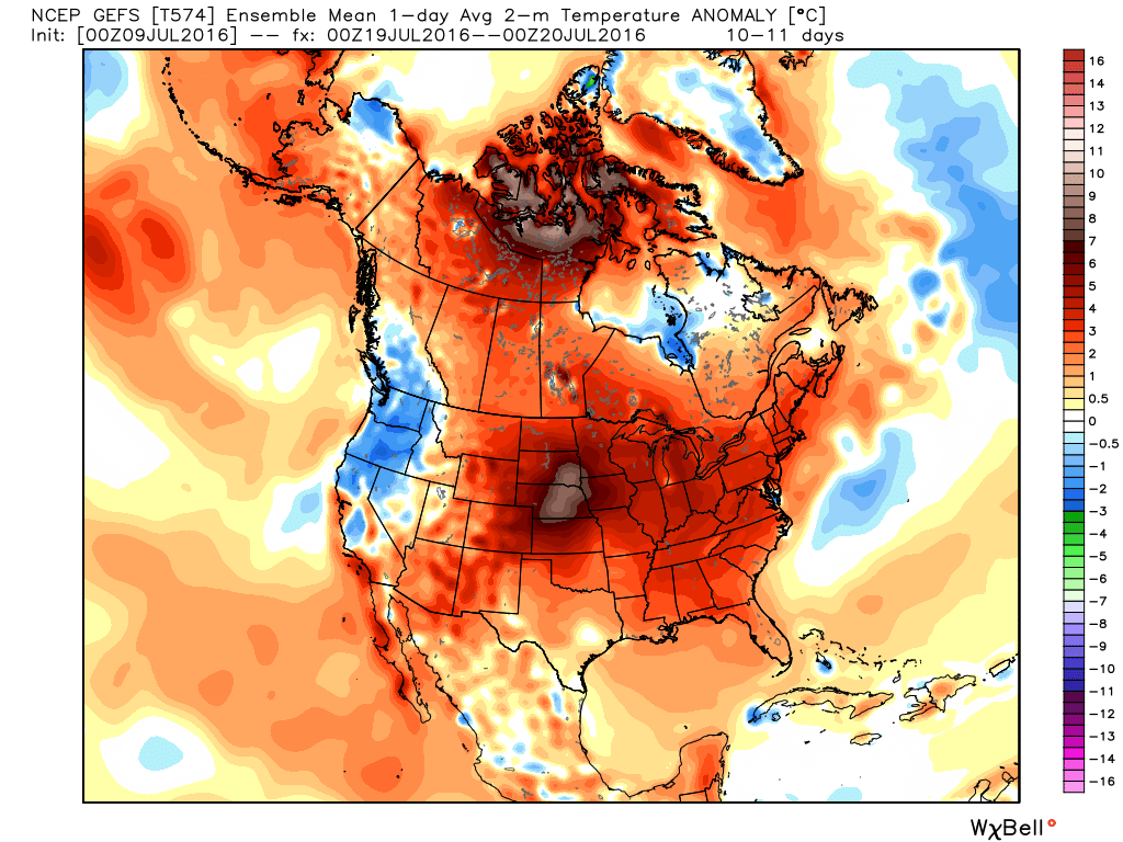
That image looks like some guy breathing fire in the northwestern part of Canada and is punching the northwest right in the throat...or he is just giving us the middle finger, can't tell.1 point
-
Y'all might get an influx of tourists next weekend if the 00z GEFS is correct. Everyone torching into oblivion except you guys. Remember, this is a day 10 ensemble mean. These are 2m temperatures:
 1 point
 -
PDO/EPAC dropping like a rock. Imagine what another two weeks of this pattern will do to SSTs. http://www.tropicaltidbits.com/analysis/ocean/cdas-sflux_ssta7diff_global_1.png1 point
-
Dewpoint maxed out at 79F IMBY this afternoon at 5:28pm, in agreement with surrounding stations, including DCA. Just missed our first 80F in that regard.
 1 point


This leaderboard is set to Vancouver/GMT-07:00