

Brian_in_Leavenworth
-
Posts
3545 -
Joined
-
Last visited
-
Days Won
7
Posts posted by Brian_in_Leavenworth
-
-
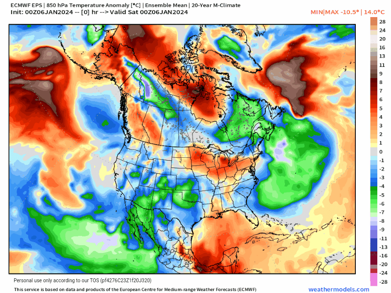
BTW, is it just me or did Pivotal change their color scheme?
-
 2
2
-
-
Just now, snow_wizard said:
That was a holy sheeeit ICON run! Brrrrr.................
-
 2
2
-
-
7 minutes ago, TigerWoodsLibido said:
And I apologize for my meltdown earlier. My bad day doesn't need to be projected onto y'all. I truly hope folks get snow and get to post amazing snow photos.
Esp @MR.SNOWMIZER @snow_wizard @SilverFallsAndrew @TT-SEA @Meatyorologist @Cold Snap and @iFred plus lots of others.
Y'all are a class act and I'm truly grateful for this forum.
We've seen far worse meltdowns, so no need to apologize. And we get why, and this is the place to vent about it, within reason of course, and I think you were within reason.
-
8
-
-
So Cliff actually said, if you cared to read it, that he doesn't make any predictions for major weather beyond 5 days because the skill of the models goes downhill rapidly.
Fair enough. But he also said the chances for a snowstorm is increasingly doubtful. Not sure why, I get the uncertainty, but it makes me wonder if he just looks at the GFS. And that would be strange considering he has been so critical of the GFS.
-
2
-
-
- Popular Post
- Popular Post
18Z Euro end of run

-
11
-
 1
1
-
1 hour ago, mjreich said:
Without naming my sources I can confirm this

It was obvious 5 years ago this would be the right answer. Combined with Spire’s remote sensing data from oceans and improved data ingestion pipelines, we’re on the cusp of a radical improvement in forecasting skill in the next 18 months. Once the training expands to include synthetic data, It’ll blow you all away how good it’s going to get and at what resolutions…
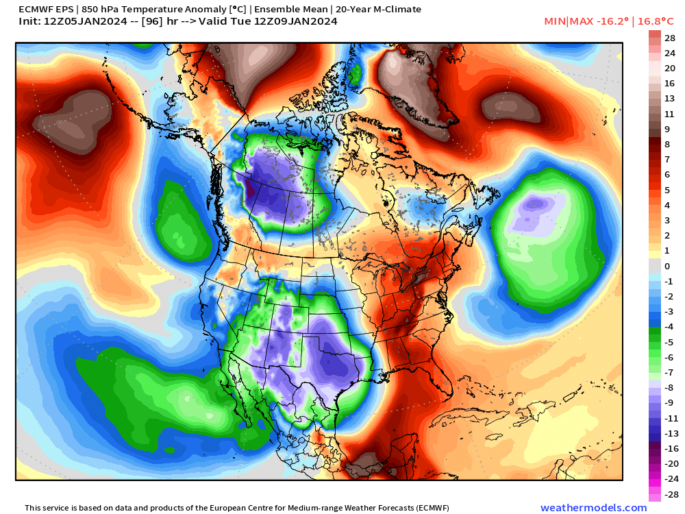
Will the AI models ever do ensembles? Since the initialization data isn't perfect, so maybe they would.
I am also guessing someday with better satellites, we may have better data to input for initialization.
-
11 minutes ago, MossMan said:
Remember just two days ago when all was well with the world with basically all of the models showing historic fun.
Memories.3 or 4 days ago the models were pretty pedestrian. Somewhat cool, mountain snow, but nothing Arctic. And then they turned on a dime. So confusing.
-
1
-
-
Weren't last nights GEM ensembles quite a bit colder than the operational?
-
-
Welcome back. Here's the EPS, minus hour 360
-
1
-
 1
1
-
 1
1
-
-
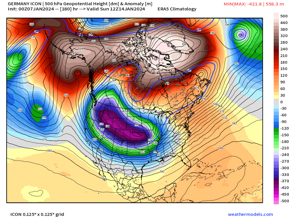
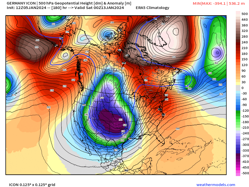
11 minutes ago, Brian_in_Leavenworth said:
Here is 18z Euro at the end
.png.3939a0aeea83293dc312fca5d8a0b6cd.png)
.png.c3c0574b999a1a53470a52d06b4d65e4.png)
12z hour 96


-
Here is 18z Euro at the end
-
8
-
-
4 minutes ago, BLI snowman said:
Not really seeing 1996 as an analog. Much higher heights over the Bering Sea and lower heights over Greenland than what's being depicted currently. PV stayed much more glued to Central Canada.

1968 is a better match over Greenland, with the PV also displaced in SW Canada much closer to where the EPS/GEFS have had it.

December 1996 was not that bitterly cold, IIRC. North Sound had a white Christmas while central and south Sound did not, snow came after Christmas.
I also distinctally remember in the week after Christmas the next storm (after the rest of Puget Sound got snow) was originally forecast to be rain. Then they made a big announcement on the TV news that they were changing the forecast to snow instead.
-
8 minutes ago, MR.SNOWMIZER said:
I wish there is more data on this, i have talked to more than a few old timers up around chesaw that have had -40 -50 a few times in the last 30 years, one of them said they had -55 in 1968. It is possible, i have seen minus 26 on a night that was only forecast to be around zero up there. Many many cold sheltered valleys. I would bet money washington has had colder than that -48 no problem.
Considering there are not a lot of places up there that had thermometers then and now, that's a good bet. I also don't know if -48 was the true low. Did the thermometers back then have the capability of automatically recording both high and low temps without someone being there to check it at the actual time of the low temperature?
-
7 minutes ago, Phil said:
The top SV analogs are late Dec 1968 and late Dec 1996.
Late December 1968 was when Winthrop and Mazama set the all time cold temperature record for WA at -48
-
1
-
 1
1
-
-
4 minutes ago, MR.SNOWMIZER said:
Blank Cliff Mass.
Cliff hasn't said yes or no. Last post was 24 hours ago, he expressed uncertainty.
-
3
-
 1
1
-
 1
1
-
-
22 minutes ago, selkirks said:
how's the icon lol
Icon shows it getting cold, then by the end (hour 180), things are being shoved east. High pressure is approaching the coast and the trough goes east.
-
11 minutes ago, SnowWillarrive said:
Mark Nelson says this is a non event.
Not quite. He just said -27 degree temps are extremely unlikely.
-
1
-
-
7 minutes ago, SpaceRace22 said:
Worth noting that although this frame says it bottoms out at -43F east of the Cascades, the terrain resolution of the GFS can not adequately account for the cold valleys like Winthrop and Mazama. In this scenario, those locations would likely not just break the all time WA state record of -48F, they would absolutely obliterate it.

Yeah I can't imagine Mazama and Winthrop not breaking the record considering how cold Spokane is
-
1
-
2
-
-
7 minutes ago, Gradient Keeper said:
Oops typo. I'm so freaking tired. That was the 6z Op. lol
No wonder, LOL.
-
1
-
1
-
-
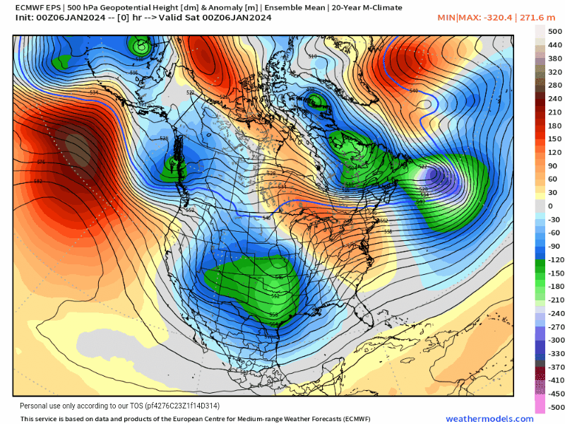
48 minutes ago, Gradient Keeper said:
Save this loop! 6z GEFS full run 500mb height anomaly
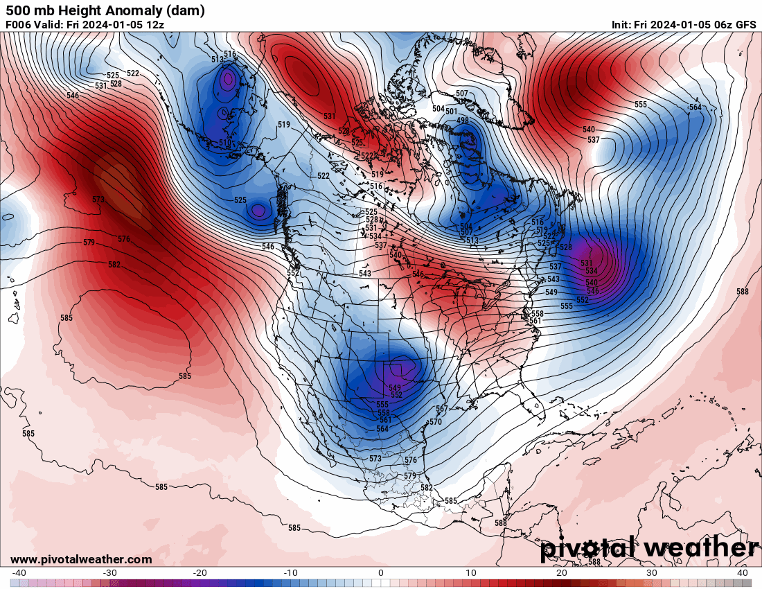
Looks very similar to the operational
-
1
-
1
-
-
2 minutes ago, SpaceRace22 said:
Um
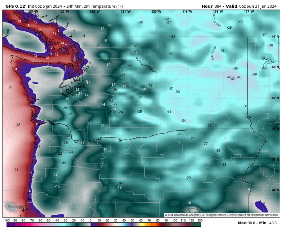
Coldest temp ever recorded in WA is -48 This has -42 near Spokane. Close to the record
-
1
-
1
-
2
-
-
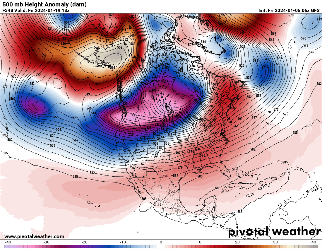
4 minutes ago, Gradient Keeper said:
HR 348 there's no stopping the onslaught of bitter air and snow. Not with that block.
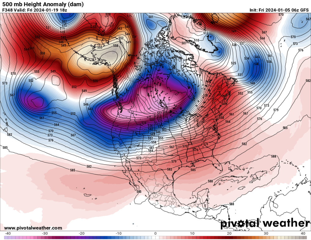
If you were to draw the craziest, coldest, snowiest scenario possible, this would be it.
-
2
-
1
-
-


January 2024 Weather in the PNW (Part II)
in West of the Rockies
Posted
Looks like they also added the Euro weeklies for paid subscribers