-
Who's Online 18 Members, 2 Anonymous, 28 Guests (See full list)
-
Activity Stream
-
4602
PNW Weather Discussion - December to Remember 2025
I was just thinking... This looks a lot like a similar storm which visited the area back in early November. Ended up with a few heavy squalls with lightning. Ballard saw some 8"/hr rain rates in one of those squalls for a brief moment...Still mad I missed seeing that in person. I'm betting that we see another 1.5" at least between Sunday and Wednesday -
4602
PNW Weather Discussion - December to Remember 2025
The December Update of my Winter Outlook is here. Will winter arrive or is it going to be endless atmospheric rivers? Predictions only: Technical version:- 3
-

-
4602
PNW Weather Discussion - December to Remember 2025
Ridge bridge in future runs would be the icing on the cake to force it all south.- 4
-
-

-

-
4602
PNW Weather Discussion - December to Remember 2025
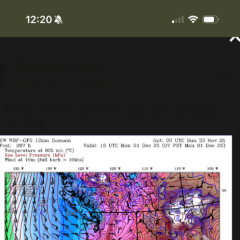
1) Fat western Alaskan ridge 2) Jet retraction 3) Bitter air in western Canada 4) Southeast US ridge We just need that Alaskan ridge to scoot east. Ridge axis ~150-155 W would be ideal to get those 500mb heights 550dam+ over Anchorage.- 5
-
-
4602
-