
Leaderboard


Popular Content
Showing content with the highest reputation on 03/24/14 in all areas
-
I had 2° this morning and I had -1° yesterday morning. 61 days with a sub zero low since December 1.2 points
-
Certainly an active pattern possibly setting up. Still have 22" of snow on the ground.2 points
-
Except for the cold now and a cool shot middle of next week, the GFS is pretty mild. Fantasy land 70s in the long range.2 points
-
00z GGEM looks rather cold for the 1st week of April...Blocking will be Rocking and controlling the weather pattern. Someone in our region is going to get hit with big snows. Too early to say where now but certainly on the table.1 point
-
I remember that storm! Yes! I AM THAT OLD!! LOL. Milwaukee received a foot of very heavy, wet, cement type snow...with winds gusting over 60 mph! The snow was icy and hurt as it hit your face! This was my first experience with thundersnow! This was the storm that really got me interested in weather and snowstorms in particular when I was young. Just a few days after the storm, it got warm and we received a lot of rain resulting in tremendous flooding. This definitely ranks as one of my favorite snowstorms in my lifetime! http://i67.photobucket.com/albums/h303/MKEman/AprilStorm1973.png1 point
-
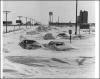
To prove that April snowstorms are real and can happen, here is a photo from my town (Cedar Rapids,Iowa) on April 10, 1973. The city received over 14 inches from this storm and it was truly one to remember. Even though highs are expected to hit around 65 by later this weekend and early next week, that does not mean we are done with winter, if I remember, we were in the 70's-80's for highs before this April 1973 blizzard hit.
 1 point
 -
No I never said that. Maybe teens I did. I think I've seen a 28° or 29° high in the first few days of April before. I'm just going by what I've learned from research. That's not my personal opinion. Here's an article on how the -NAO of 2012 brought the heat on! http://www.accuweather.com/en/weather-blogs/meteomadness/lets-blame-the-nao-on-the-heatwave/67959 The main reason I'm downplaying much more wintry cold chances is because the polar vortex is collapsing.1 point
-
He moved to the north-central Pacific to be one with the PDO. No cable internet.1 point
-
We've had two games cancelled so far. Looking like maybe this Friday could be our first one---maybe. As I'm typing on my phone waiting for the start go baseball practice, I see a couple snowflakes falling outside. Too funny.1 point
-
James, 12z Euro showing that storm also with tons of moisture developing out in the Plains and heads towards the Lakes. Not cold enough for all snow but showing something. Looks like 60's are still game for Sun-Mon before a cold front sweeps through Monday and a system tries to run up along it. th_snow gets hammered next 10 days!1 point
-
It was more about high school ball as my son is a freshman and they are getting ansy and are ready to get this season underway.1 point
-
Hawks Playoff Tickets went on sale this morning! Playoffs start April 16th. I checked for tickets for the 1st round and they are sold out already.1 point
-
Those are some ridiculous lows for late March! 17° this morning feels warm when looking at those numbers. EURO mainly showing snow from North Dakota to the U.P. of MI through 240 hours. Cold air is disconnected from the system near the 1st. Looks like 3 good rainstorms for the lower Lakes and corn belt coming up. GFS is slightly further north.1 point
-
Morning lows were higher than expected. Hit 17°. Local forecasters have temps near 60° on Sunday.1 point
-
Write a letter.1 point
-
Was about to report the temp when I realized I brought my temp gauge in tonight. Not quite 71 degrees outside1 point


This leaderboard is set to Vancouver/GMT-07:00