
Leaderboard


Popular Content
Showing content with the highest reputation on 08/14/20 in all areas
-
Happy Friday! The beat goes on here in the valley of the Sun Heat! Yesterday, we tied the record at PHX of 115F and today we are forecasted to top 116F. Some notable Heat stats here in the valley: 1) Most days at 115F or better: 7 days and counting (old record 7 from 1974) 2) Most days at 110F or more: 37 days and counting 3) Most lows in the 90's: 20 days and counting (old record 15 from 2013)2 points
-
Picked up about an inch of rain from that last wave. Should get hit by the wave along the cold front this morning.2 points
-
Front moved through here dry as usual. Dew has dropped from 77 to now 68. Really been a very poor rain and storm season in my immediate area. Many others north and south have had an unbelievable year. The haves and have nots continues. Can it change for the snow season?1 point
-
Well it’s looking like the awful rain/storm season might continue here in the Omaha metro tonight. Solid line of storms to our west has nearly broken apart and the best storm cell of the day was directly west of us, and decided to drop straight south while the rest of the line was moving due east. I am throwing in the towel on the storm season for the rest of the summer if we can’t get anything to develop towards our area tonight... moderate drought conditions must beget severe drought around here this year. With what looks like two weeks of bone dry weather upcoming, things are going to get much worse before they get better.1 point
-
Yeah. I have no disagreements here. All hints point to a violent but beautiful autumn here. Here's to the last big week or so of major summer heat. Good riddance.1 point
-
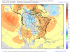
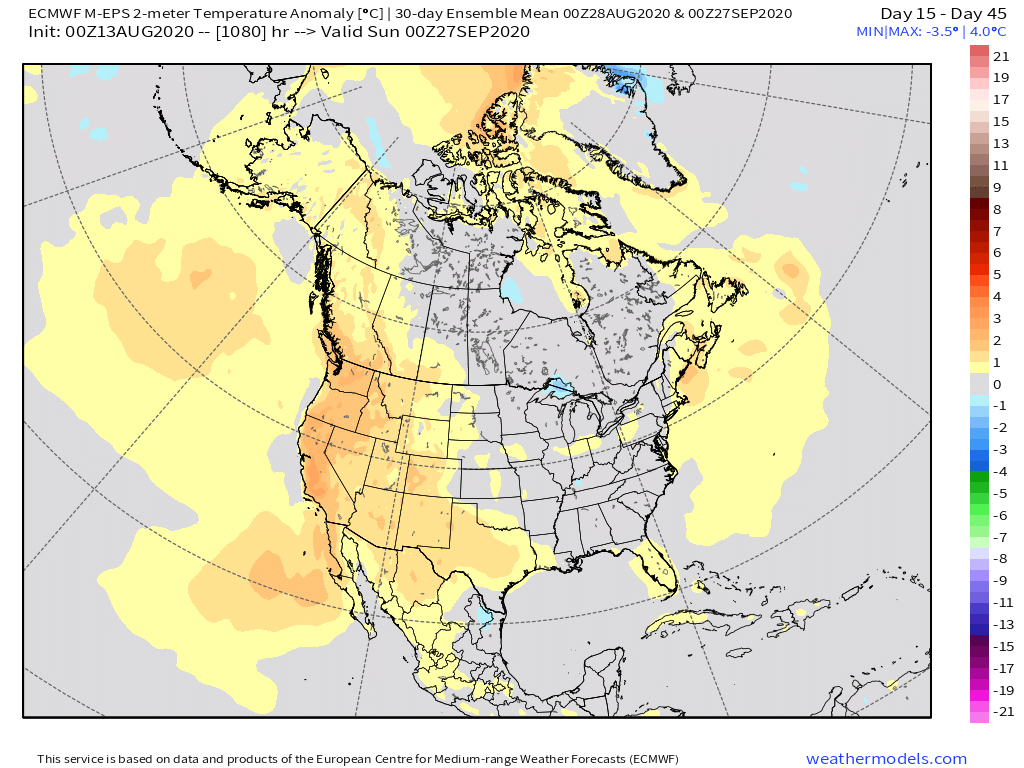
It's interesting to see both the CFSv2 and Euro weeklies agreeing on an amplified North American blocking pattern with massive ridges setting up off both coasts and suggesting a large area of seasonal to cooler than normal temps for those east of the Rockies. This would certainly flip the pattern we have seen in recent years for the month of September. Both models are also seeing a significant cool shot end of September along with multiple rounds of cold fronts during the entire month. I got a feeling it's going to get rather volatile as Autumn settles a lot earlier this year than in recent years. At the moment, it does not appear that "Endlesss Summer" will have legs this season.
 1 point
 -
Been super busy last couple of days. Had to fly to Boston-NYC-Wash DC on business. Very pleased w aircraft regulations as well. Airports are much less crowded, something I am not accustomed to. Anyways, so, back in MI, temps here are at 83F and a muggy dew. I heard about TS Josephine. Looks like it is a fishstorm and will remain at that cat.1 point
-
Someone fell asleep at their desk at FGF. No warning in Fargo despite 70mph gusts.1 point
-
Sounds like this is the last day of the humidity for awhile, thank goodness. My son is a freshman, and at our school 9-12 grade football practices together. He is just exhausted when he gets home due to the high dews. Tomorrow looks like dews in the 50's and NWS Hastings says next week will be warm but dews in the 50's to low 60's is much more comfortable. A/C at schools is running non stop.1 point
-
It’s crazy I tell ya! I’m surprised there aren’t more fires TBH. I also think it’s also due to the lack of thunderstorms which can produce dry lighting and spark fires. Looking out into the extended, when I get back home, the weather is looking mighty fine! I’m ok with the Heat for now...but ya, it’s friggin’ Hot my man!1 point
-
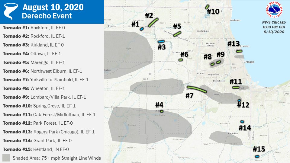
@Tom you're baking down there! And that is quite the story over there in N IL. 15 tornadoes!!?1 point
-
Just a gorgeous shot of a sprite back on July 2nd, 2020...
 1 point
 -
Wow, that is some real heat. I just checked the record high for August there is 117 on August 14, 2015. The reading of 115 is in a tie for the 3rd hottest August day there and 116 is the 2nd hottest.1 point
-
Here's a tweet from the NWS at Chicago and an update on the final count of tornado's from the Derecho....15...
 1 point
 -
Nice wake-up call.1 point
-
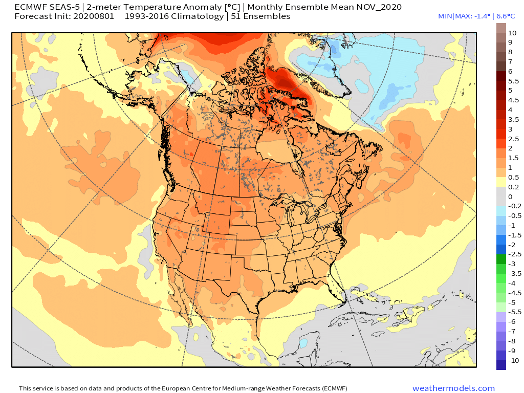
Here is the latest Euro Seasonal...it is also quite dry...if you look closely at the modeled temps, it is showing very subtle signs of a trough in the East. If you take away the warm bias in the modeling, IMO, it suggests to look for more seasonal temps and even BN in places east of the Rockies.
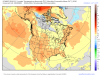
 1 point


This leaderboard is set to Vancouver/GMT-07:00