-
Who's Online 16 Members, 0 Anonymous, 205 Guests (See full list)
-
Activity Stream
-
322
August 2026 Observations and Discussions
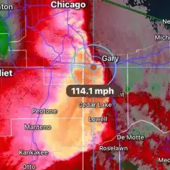
LOT released detailed maps of the derecho, based on survey info and some measured wind gusts. Looks like there was a 5-8 mile wide swath of winds >80 mph in northwest IN, with a much larger area of 70 mph (and some narrow 80+ swaths/spots mixed in that zone too). You can see some pockets of 100+ mph in extreme eastern IL, one just east of the IL/IN border and another over toward Gary and Portage. They don't have it labeled in the legend, but I assume the dark purple circles are 110 mph, because those coincide with the areas that LOT mentioned in their writeup. -
2176
-
2176
August 2026 PNW Weather
Ironically... the 12Z ECMWF shows it being sunny in the Seattle area from Friday - Monday next weekened. -
2176
-
2176
August 2026 PNW Weather
Bad timing for the holiday weekend, but that would be a huge blessing for Central Oregon.- 1
-

-