All Activity
- Past hour
-
 That twister was just on TV and it looked like a scene from the movie “twister”…such a powerful, yet beautiful part of nature. So much emotion seeing this on the news. Very sad to see all the destruction. There is also the beauty I see in it from afar. Glad ya’ ll are safe out there. Still a day or two more to go.
 -
 It appears more tornadoes are popping out of several cells south of Des Moines
 -
I get my news from a variety of sources. Drudge, Fox News, Axios, Politico, The Hill, Ground News, CNBC, RealClearPolitics, etc. Hell, I'll even go see what CNN has up occasionally just for the hell of it. Sometimes it's pretty funny. Where do you get your "source material" from?
-
 CLOUDY AGAIN
 -
 Central Nebraska tornado that happened around 1:30 today. This was around Elba.
 -
Lincoln to Omaha tornado. Damage being done in Elkorn.
-
I believe this is the tornado that started at Eppley.
-
Historic day for sure. We had a single supercell storm start off in Central Nebraska early afternoon; it produced a major wedge and from there things went bananas. Omaha saw a huge wedge come up from Lincoln and then had an additional cell pop up and drop a tornado on Eppley Airfield. Both supercells then went into Iowa and are still producing major tornadoes.
-
La Nina is rapidly emerging on the SSTA map.

-
Nothing to be proud of but this could be a record breaker. Seeing some of the damage footage it for sure looks like EF4 damage at least.
-
I don't get KETV from my area so went online and was watching Bill. It touched down during the live broadcast; just a crazy day here in Nebraska.
-
Nothing here, there was a tornado 15 miles west of me that I tried to catch up too but just missed it. Not a good day for Nebraska; those from Lincoln, Waterloo, Elkorn and then into Iowa saw significant damage. Just a massive prolific supercell that left its mark on the state. I pray for those that were in the path.
- Yesterday
-
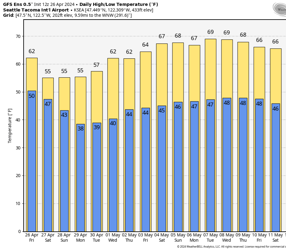
12Z GEFS was decent.

-
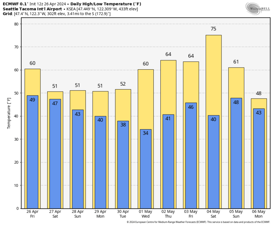
OK. 15 hours of daylight and SEA will struggle to get out of the 40s. That is some notable troughing.
-
I mean, we can go with PDX records are all that matter if you want. But you yourself have many times pointed out how unrepresentative the airport is of your area and much of the metro. Thought that was something we agreed on.
-
Cool. With nearly 15 hours of daylight, likely gonna be some sun poking through as there almost always is at this point in the season.
-
I have access to the internet Jared. On the plane when my son asked about the weekend I told him Friday afternoon would be the best period. Playing out as expected.
-
18z sure looked nice. Let’s hope the models flip back some. Worth noting the EPS hasn’t really been on board for some of the crazy ridging the GFS has been showing at times the last 24 hours. The 12z Euro was ridgier in the 6-10 day range than past runs, though.
-
Just let Tim believe he's missing the most MISERABLE, DREARY week ever whiles he's gone.
-
Sounds like nitpicking to me.
-
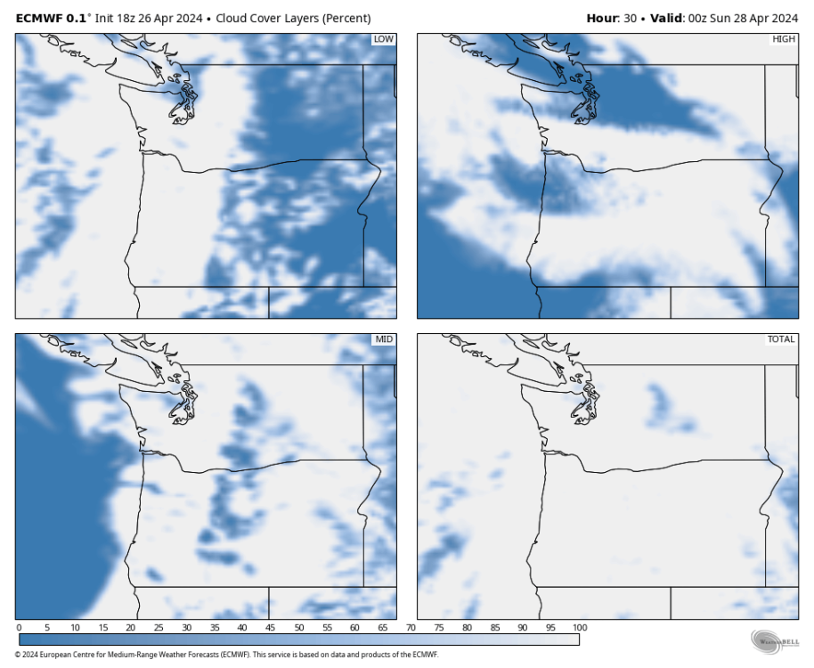
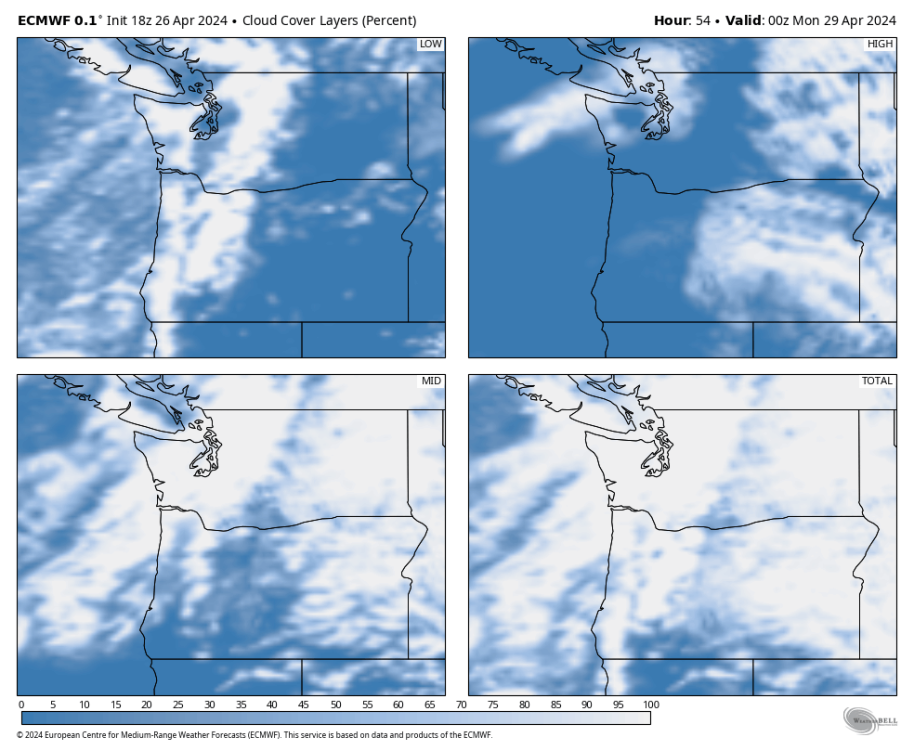
Solid mid level clouds both days over the weekend. Lower left box in each square.
-
Colder upper level airmass this weekend moves in. Doesn't look like a ton of stratiform precip though. There's likely going to be a fair amount of sun breakage most days.
-
The point was you say "we" saw a record hot May in 2023, but it was far from the whole metro - just PDX. Some months have been legit record hot across the whole area, but that wasn't one of them. Obviously it was very dry and warm, but the whole record month thing doesn't hold as much weight when it's a station seeing 50% more of them than other places.
-
ECMWF showed decent sun breaks for the Seattle area for today for many runs. The high temps over the weekend and into early next week indicate sun breaks won't be nearly as prevalent. Pretty hard for SEA to only get to 51 with sun breaks like today.