All Activity
- Past hour
-
@Hawkeye @OttumwaSnomow...Storm Magnet must be in use...E IA folks are under the gun!
-

May 2024 Pacific Northwest Weather
the_convergence_zone replied to snow_wizard's topic in West of the Rockies
Looks like it will fall apart before reaching me. Got 0.06” out of this event. -
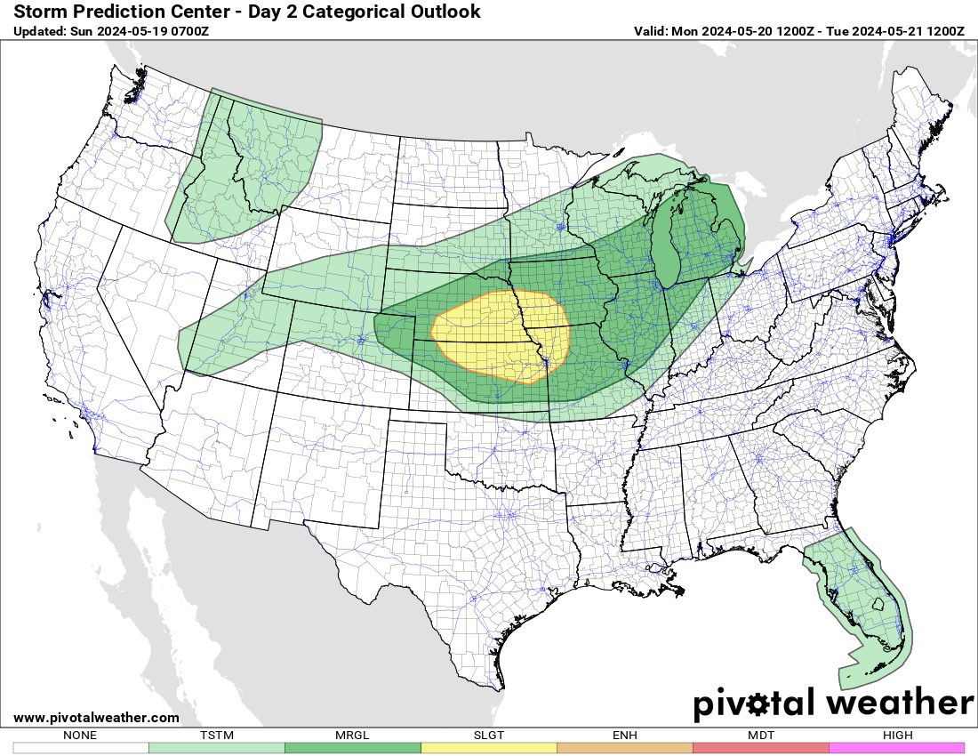
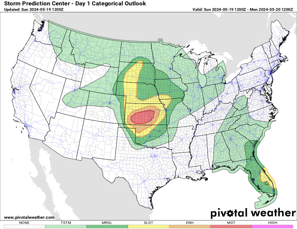
Yesterday was summer like here I had a high of 88 with some humidity. More of the same expected today with highs in the upper 80s. Cams show a weakening line of storms here late tonight and some scattered activity tomorrow. Tuesday looks to be the best chance of severe weather here in what looks like a very active week.


-
Hello from the "Valley of the Sun!"....Home Sweet Home...it was fun seeing my family back in Chicago but it was also sorta chaotic living with my siblings and their kiddos, esp my younger sisters nieces...girls are certainly a handful! While it was a different experience coming back to my old neighborhood and not staying in my old home, I had the vibe like I was on vacation in a weird way. Nevertheless, I'm planning on visiting again this summer sometime. Yesterday, PHX torched to a season high of 104F as Nature reminded me that it gets HOT in May! TBH, it didn't feel overwhelmingly hot with the nice breeze.
-
Yesterday was a summer like day with the official H/L at Grand Rapids of 83/49. There was no rainfall and the sun was out 90% of the possible time. The average wind speed was 4.1 MPH. For today the average H/L is 71/50 the record high of 91 was set in 1977 and the record low of 30 was set in 2002. The most rainfall of 2.88” fell in 1938. Last year the H/L was 68/50 and there was 0.02” of rain. The overnight low here in MBY was summer like 63 and the current temperature is 68 with clear skies
-

May 2024 Pacific Northwest Weather
Meatyorologist replied to snow_wizard's topic in West of the Rockies
Wet! - Today
-
May 2024 Pacific Northwest Weather
Meatyorologist replied to snow_wizard's topic in West of the Rockies
KSEA will challenge 1996 for the record min/max this Tuesday. Mark is 52F. Not sure if we'll beat it but we could match.... The margins are razor thin. -
May 2024 Pacific Northwest Weather
Meatyorologist replied to snow_wizard's topic in West of the Rockies
Mesoscale models picked up on this shower activity. The bulk of the cold air is now passing overhead and there are some converging airstreams in the lee of both the Olympics and Vancouver Island under stout NW flow as our ULL exits the westside. That and the Snohomish plateau is initiating a lot of this. Looking at radar, the north end of the city is getting some leftovers. Most of it is dissipating before it quite reaches here, but I suspect that could change at any point.
-
Is anyone else getting rain right now? This kinda took me by surprise since precip chances are supposed to be diminishing
-
Raining pretty good in Edmonds right now
-

May 2024 Pacific Northwest Weather
TigerWoodsLibido replied to snow_wizard's topic in West of the Rockies
49F and cloudy. Nice night. -

May 2024 Pacific Northwest Weather
Cascadia_Wx replied to snow_wizard's topic in West of the Rockies
Chilly evening out there with clearing. Already down to 44 which is a new low for the day. -

2024-2025 California and Southwest Weather Thread
May Grey replied to Anti Marine Layer's topic in West of the Rockies
The high was only 61F today, colder than forecasted thanks to the clouds never cleared up. -

May 2024 Pacific Northwest Weather
snow_wizard replied to snow_wizard's topic in West of the Rockies
I think some places have a shot at ending up below the old normal for monthly average. SEA is certainly in the running for that. -
May 2024 Pacific Northwest Weather
snow_wizard replied to snow_wizard's topic in West of the Rockies
And bloody cold! -
0.00” on the day.
-

May 2024 Pacific Northwest Weather
LowerGarfield replied to snow_wizard's topic in West of the Rockies
Its about 50 degrees here. 10 o'clock and all is well. -
May 2024 Pacific Northwest Weather
Cascadia_Wx replied to snow_wizard's topic in West of the Rockies
A close to average month appears to be within reach for PDX now. They were +2.4 through yesterday. -
Might also be a couple of degrees less than today
-
May 2024 Pacific Northwest Weather
Meatyorologist replied to snow_wizard's topic in West of the Rockies
I don't want to jinx anything but Tuesday's system looks like a real soaker. -
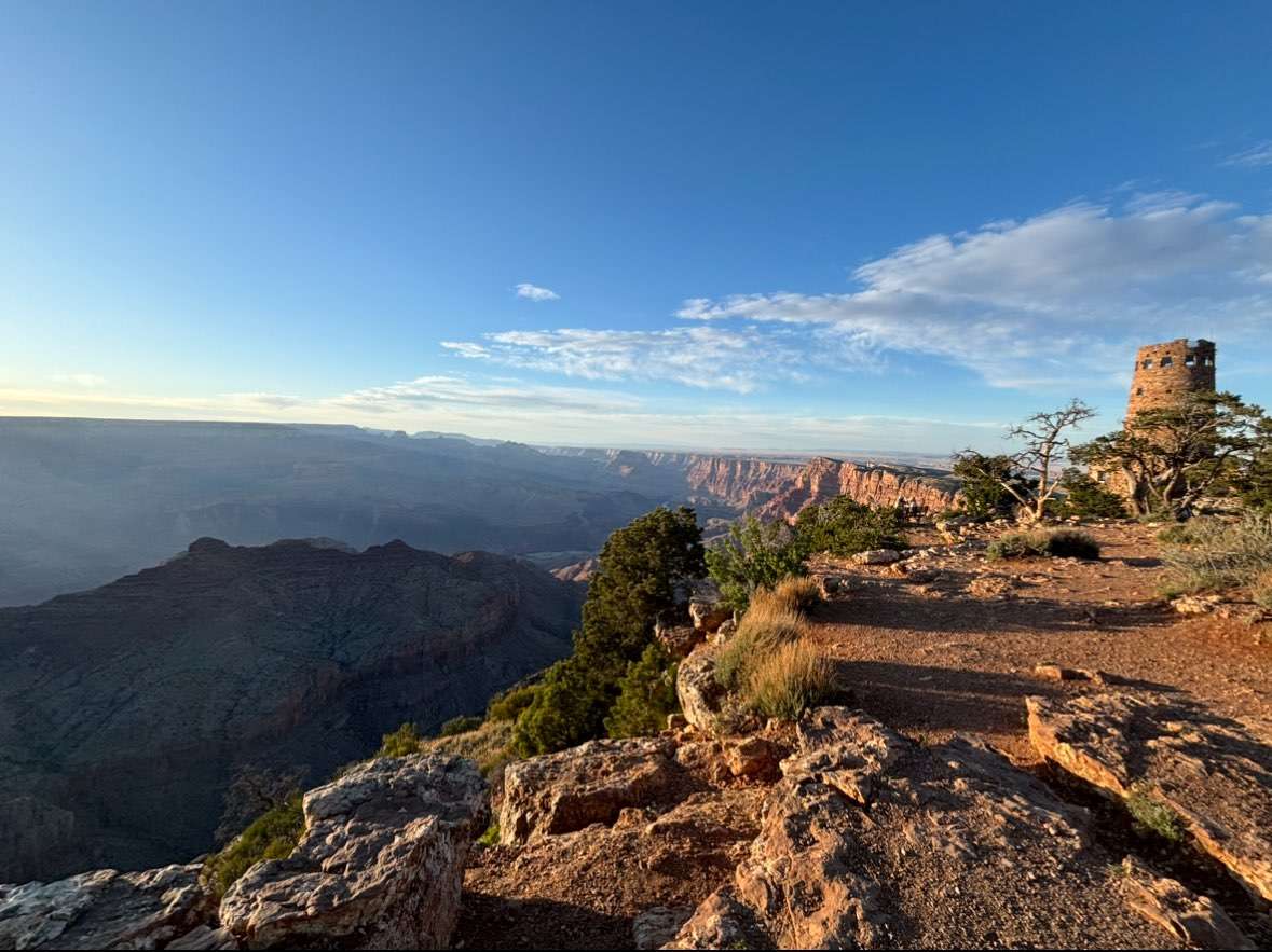
We did the needles district in canyonlands yesterday and absolutely loved it. We made a last minute decision to go to Mesa Verde National park in SW Colorado on the way to the Grand Canyon and we were blown away by how cool it was! We even got to see a young bear strolling around. Just got to the Grand Canyon about an hour ago. Full day here tomorrow then we’re coming back home.


- 2588 replies
-
- 10
-

-
56/45 IMBY today. All I know is that my parents are glad that they are missing the cool and rainy weather but I’m hoping I can come back to some cool and rainy weather on the 26th after being in 90 degree humid weather for an entire week.
-
 May 18 high: 69 F 2024 average high for Downtown LA as of May 18: 70.66 F Average high for May 18-31 2024 required to tie last May: 68.54 F
 -
May 2024 Pacific Northwest Weather
Cascadia_Wx replied to snow_wizard's topic in West of the Rockies
Cool day here for the latter half of May. 59/45 spread. Clear overnight then partly to mostly cloudy with a band of heavier showers moving through in the afternoon. Picked up just under .10” of rain. Chilly sunset out there currently with some clearing, a brisk NW breeze and a current temp of 50. -
Warm today. 92. Another tomorrow through Tuesday. Then we have a a 30-50% chance of rain Mon and Tues. So far a nice Spring pattern. Beautiful day today.