All Activity
- Past hour
-
Brrr.
-
High clouds now... day is ruined!
-
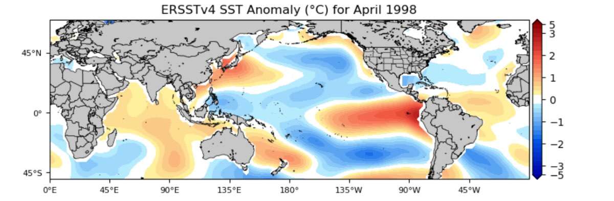
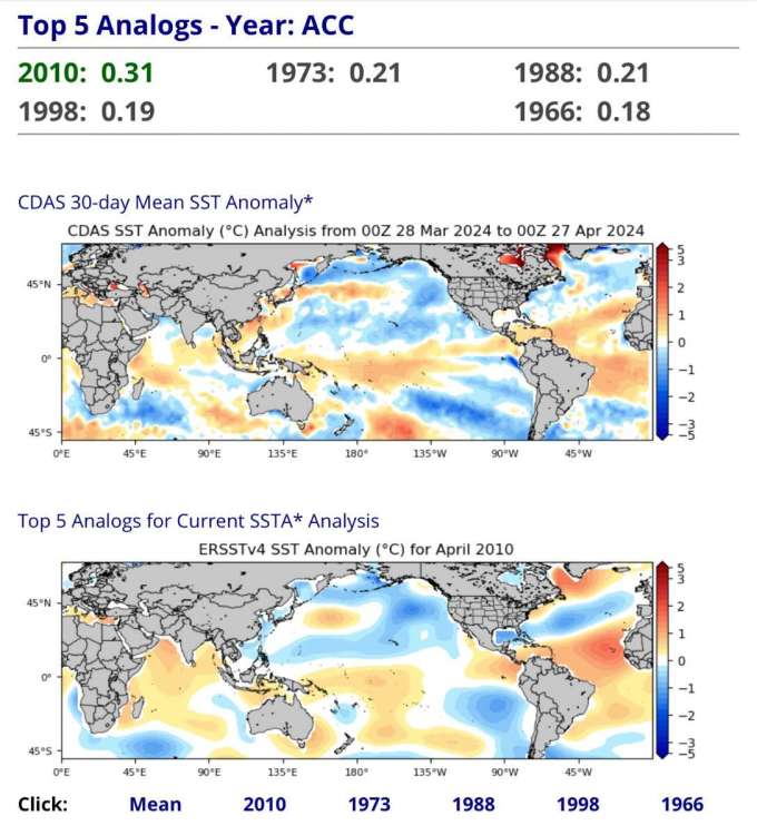
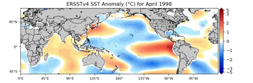
This niño definitely isn’t collapsing the way 1998 did. Cold tongue is more pronounced like 1973 and 1988. Overall, 2010 is still the best global SSTA match. Note how 1998 still had the raging EPAC warm anomaly (and maintained it into the summer). So I think the LF signature of tropical forcing will be displaced into the E-Hem as the niña establishes (relatively speaking).
-
Yeah Atlantic influence actually helps at this time of year. Water temps similar to late Nov at this point in the seasonal cycle. That script flips completely by midsummer, though.
-
You need one of these!!

-
Yes today’s the last nice day. Getting North Bend weather at the moment but will be in the mid-80s this time tomorrow.
-
Spiked is a great site. Analysis only matters if it’s from a left wing source and the author has been properly indoctrinated?
- Today
-

April 2024 Weather in the PNW
Anti Marine Layer replied to Tyler Mode's topic in West of the Rockies
Sounds like a Phil comment -

April 2024 Weather in the PNW
SilverFallsAndrew replied to Tyler Mode's topic in West of the Rockies
Light rain in the SLE. -
Why should we care about a no-named author from a no-named source of opinions on legal matters? I doubt that guy has a bachelors degree let alone a law degree. Read better people. You might as well be linking us your friends' facebook posts.
-
DCA is currently 57. Phil must have been looking ahead to Monday.
-
Yeah, BLI's anomalies seem to have overcorrected from what they saw last decade, similar to SEA and SLE to a lesser degree. Opposite of what's happened with OLM and PDX recently.
-
A little surprise snow here this am. Just 35 at DEN, pretty raw for noon at the end of April.
-
BLI was -1.1 for March and currently -1.7 for April. The last 6 weeks have been very torchy for western WA.
-
Still lots of low clouds to dispose of.
-
You don’t know what the NAO is? And I’ve linked references to the TNH multiple times. CPC references it as a seasonal/cold season index, but it’s present in some form year round. https://www.cpc.ncep.noaa.gov/data/teledoc/tnh.shtml
-
To be fair, that's SEA and they've been an outlier on the cool side with anomalies. Seattle city office was +1.0 for March, and is running +.7 for April. Overall, not a torchy spring so far, just a bit above normal most places.
-

April 2024 Weather in the PNW
Sunriver Snow Zone replied to Tyler Mode's topic in West of the Rockies
I think the summer is going to be stuck in a >XKZ/HLT pattern under WFG+/ABC- conditions, due to the HVJE/KSUF forcing in the +1A-HDW region of the JSHDW/North Antarctic Ocean, causing a mass FNEO× pattern in the PRHEU layer of the atmosphere. This summer is going to be a peak HFHSOUF/IFGDSJ- pattern in the east coast, and a UFHEJ+ pattern in the west coast. Just my opinion based on the HDGS/PAHF/IAHC+×-< forcing. -
You need some latitude and/or altitude
-
A gorgeous 75 here and all blue sky here... waaaaaaay to your south.
-
90s already beginning here. 5 months from now it’ll be late September..and probably have the same exact weather only more humid. Why can’t winter last half the year too?
-
I’m liking the -NAO signal heading into May, though. Many of the post-niño summers have a period of late-spring blocking, offering a final reprieve before hell starts. Hopefully we can take advantage of that opportunity. Also would be another sign the system state is far-removed from the +TNH state that has dominated the majority of recent summers.
-
April 2024 Weather in the PNW
Sunriver Snow Zone replied to Tyler Mode's topic in West of the Rockies
Its not even close to the same amount
-
 Action has started early. Be safe Oklahoma and Kansas folks. Reed Timmer Extreme Meteorologist The latest NADOCAST forecast of tornado probabilities has just gone through the roof across portions of Oklahoma into southern Kansas including OKC to Wichita. It will be interesting to see if this tornado outrbeak verifies. Stay tuned to watches and warnings across the southern Plains and have those family safety plans in place and ready to execute at the drop of a hat
 -
Maybe some life giving sunshine from our Lord and Creator. And since climate change is real and accelerating and all I hear on here is that its only a matter of time until the forests burn then it really doesn't matter anyways. Just re-arranging deck chairs on the Titanic if the ship is inevitably sinking. Right Andrew? Lean into your climate change drama.