
Leaderboard


Popular Content
Showing content with the highest reputation on 01/10/15 in all areas
-
At your age...it must suck living with your mother. Soupy morning. 38f.4 points
-
By the way, in my 23 years here in the NW, I have seen quite a few years with only a couple of inches of snow (in my convergence zone area) and out of season at that. I think that is the climate here! Why complain, enjoy! I love my low heating bills. The mountains sure are beautiful. How about the valley fog! Want to see boring weather, go to San Diego, Key West, Brownsville Texas, ....3 points
-
Looking pretty decent so far. The potential storm is still showing up at hr 144 and things looked pretty suppressed thereafter (could be good for California); we'll see how the run finishes but I'm liking the storm shown to develop in the Arctic progressing north of the Yukon. Strong storms over Western Nunavut seem to be beneficial teleconnection-wise for bringing Arctic air into the PNW (edit: it's a little to far north on this run however, ideally it'd sit in the NW Hudson Bay). Edit: No to cold in the next 10 days, but that was kind of a given. However, lots of very cold air trapped up to the north of Alaska and ridging shown to be suppressed on the West Coast (for a change). This would be a nice time to have a traditional "Siberian High" roll down from the North. http://www.tropicaltidbits.com/analysis/models/ecmwf/2015011100/ecmwf_T850_namer_11.png2 points
-
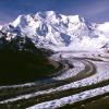
On the Canadian side of the border, Rossland, BC has a pretty amazing climate as far as climates in the PNW go. They average about 14ft of snow per winter with an average high of 27F in both December and January, and snow tends to come in the form of large storms with plenty cold clear days in between. They also tend to sit above the nasty inversion that can form in interior valleys. Summer temperatures there are almost identical to coast climates without the marine stratus and more thunderstorms. I used to go up there all the time when my grandparents lived there. The scenery is also very PNW-like, with large conifers and visible mountains: http://www.snow-forecast.com/system/images/13240/large/Columbia-Ave-in-Rossland_-Red-Mountain_-Michael-Fisher.jpg?13241524602 points
-
They destroy MD for severe weather and cold. I'd take Wisconsin's climate over your's pretty easily.2 points
-
I came here from the midwest. You haven't seen a heating bill till you've seen something like what they have in Chicago. Our hydroelectric is cheaper than anything they use there. (We don't use AC in the summer either). We really have a very nice climate (with interest from time to time), you just need to change your standards.2 points
-
I guess my point was, cold and snow is only a small aspect of interesting weather. Wind, rain, etc. can be very exciting as well. I see so many posts complaining about the lack of weather (cold and snow) while we look beyond what could be a very exciting period in the day 4-6 zone. By the way, once the storms blow through in the mid range, there really is no way to tell exactly how things will evolve. But ridging and long wave retrogression is not uncommon. Models beyond day 6-7 mean nada right now.2 points
-
Hearing all this talk about how boring the weather is. NOT!!! Look at that ECMWF. Look at the Canadian. It looks to me that we are getting ready to move into a storm cycle here in the NW with wind, big coastal waves, potentially heavy precipitation at times -- all to be followed by possible retrogression and amplification of the flow in the long term (though the ridge may be too close to support arctic air. It will be fun to see how things work out.2 points
-
I think he's throwing spaghetti at the wall at the moment.2 points
-
Hence the reason I want to live in a dry continental climate.1 point
-
To each his own. Of course, in the midwest - I always had something on (heat or air). Could not open the windows more than a couple weeks a year it seemed. When I lived in various places on the north Gulf coast, very hot and humid 6 months out of the year followed by a nice and short shoulder season - with lots of dreary weather in the winter. Our springs -- not really all that bad - bright and cool with only light showers at times.1 point
-
1 point
-
The weather today is depressing. The whole area is enveloped in a thick soupy fog with light drizzle. Currently 30 degrees at Stevens Pass with Fog and light drizzle.1 point
-
Final call for ORD: 2.61 point
-
My wife just opened up our PUD bill this morning and had a mini meltdown, i had to remind her that the billing cycle included 3 arctic intrusions.1 point
-
Actually on my phone today so if someone else can do it that would be great. Not the best posting on this phone.1 point
-
We should start a seperate thread for this event.1 point
-
Wouldn't be surprised if this snow shield presses even farther north into the southern counties of WI the way this is trending. Nice lil "thump snow" on the way Sunday night! We have the Hawks playing at 7pm and a Sunday night snow event...Boom! My kind of winter nights.1 point
-
The last two winters have felt VERY similar. I keep flashing back to last January whenever I'm outside. Its weird.1 point
-
Interesting discussion by LOT NON GFS MODEL GUIDANCE HAS TRENDED A BIT SLOWER WITH THE TIMING OF THE COLD FRONTAL BOUNDARY APPROACHING THE AREA FROM THE NORTH...AND NOW SUGGESTS THAT A BAND OF 700 MB FRONTOGENESIS COULD SET UP RIGHT OVER THE CHICAGO AREA SUNDAY EVENING. THIS WOULD FAVOR SNOWFALL GETTING FARTHER NORTH ACROSS ILLINOIS THEN PREVIOUSLY THOUGHT. IN ADDITION TO THIS...GUIDANCE IS ALSO SUGGESTING THAT THE AREA WILL BE WITHIN THE ENTRANCE REGION OF AN UPPER LEVEL JET STREAK ACROSS THE UPPER GREAT LAKES AND INTO SOUTHEASTERN CANADA. WITH THIS IN MIND...I HAVE TRENDED THE FORECAST IN THIS DIRECTION. THE THREAT OF MODERATE TO POSSIBLY EVEN SOME HEAVIER SNOW RATES COULD STILL PUSH AMOUNTS INTO THE 2 TO 4 INCH RANGE ACROSS THE AREA FROM THE CHICAGO METRO AREA...WEST-SOUTHWESTWARD TO NEAR MENDOTA AND POINTS SOUTH.1 point
-
It is, but not complaining...I'll take what we can get...a couple inches more would boost the overall snow pack in N IL....a solid 6"+ snow pack would do us good once the warming comes for a couple days.1 point
-
Could be looking at advisories this afternoon from LOT...I love these surprise snowfalls. This event may boost ORD above normal for the season to date! The way I see the pattern setting up to close out January with more blocking organizing, and the jet stream reaching its peak some time in early February, we are in for one heck of a ride as the wettest part of the LRC develops right during that time frame. I think doubters of this Winter will be shaking some heads by month's end.1 point
-
18z NAM farther north again with heavier banding. Getting more interesting with each run. Could be looking at decent accumulation if this stays the track.1 point
-
I'd like to see some Aleutian ridging at some point.1 point
-
That's like rooting for an Arctic Blast in the east!1 point
-
. I am sooo embarrassed you put that picture of me up. You said you would'nt... This current weather pattern put my narcolepsy into overdrive. And it was so warm I had no reason to wear a shirt.1 point
-
That was taken at dinner time? Man, that sun angle is creeping up fast!1 point
-
It's not for everybody. If it was my house would probably be a lot smaller.1 point
-
I'm fine, thanks. I don't mind being one of the clueless millions who will be swept into ice age chaos with little or no warning.1 point
-
Big article about these very issues in the National Enquirer today.1 point
-
Things just feel off with the weather this winter season.1 point
-
I'm not a great MJO guy like you and Phil, but I do understand the fundamentals--and I think I would agree with your assessment. Good call!1 point
-
Might be the best way to tell if our winter is fully cooked! LOLOLOLOL!1 point
-
sun is trying to win the battle against the fog. chilly morning ...32f. hopefully, tomorrow morning will be clear as there is a decent viewing of the ISS.1 point
-
Is it okay if I post the Canadian monthly extremes here? Better to ask forgiveness than permission, so here goes... January: 16.8°C (62.2°F) CLARESHOLM, ALBERTA note: Second place at 16.5°C was BURWASH, YUKON!! -48°C (-54.4°F) ST PRIME, QUEBEC February: 15.0°C(59°F) TAHSIS VILLAGE, OLIVER, & CHROME ISLAND, BC -50.4°C (-58.7°F) EUREKA, NUNAVUT March: 18.5°C(65.3°F) NOOTKA LIGHTSTATION, BC note: WHITE ROCK, BC at virtual tie at 18.4°C -47°C (-52.6°F) EUREKA, NUNAVUT April: 28.5°C (83.3°F) HEMMINGFORD, QUEBEC -43°C (-45.4°F) EUREKA, NUNAVUT May: 35.4°C (95.7°F) SWAN RIVER, MANITOBA -26.6°C (-15.9°F) TALOYOAK & HALL BEACH, NUNAVUT June: 34.7°C (94.5°F) FORT SEVERN, ONTARIO -13.3°C (8.1°F) AULAVIK NATIONAL PARK, NUNAVUT July: 41.7°C (107.1°F) ASHCROFT, BC -4.7°C (23.5°F) ISACHSEN, NUNAVUT August: 40.1°C (104.2°F) LYTTON, BC -7.1°C (19.2°F) CHETWYND, BC note: Both extremes are in BC September: 38°C (100.4°F) MUENSTER, SASKATCHEWAN -22.9°C (-9.2°F) SVARTEVAEG, NUNAVUT October: 29.0°C (84.2°F) ST-ANICET, QUEBEC -35.2°C (-31.4°F) EUREKA, NUNAVUT November: 21.3°C (70.3°F) ST-ANICET, QUEBEC -42.3°C (-44.1°F) KUGAARUK, NUNAVUT Note: HENDRICKSON CREEK, ALBERTA WAS CLOSE BEHIND AT -42°C. December: 18.5°C (65.3°F) GREENWOOD, NOVA SCOTIA -44.3°C (-47.7°F) SHEPHERD BAY, NUNAVUT Note: In most years the Yukon is the national cold extreme, but not in 2014, nor 2013 for that matter. The national cold spot was in the Yukon for 6 years in a row, but Eureka, Nunavut has been for two years in a row now. This is the first time in history that Eureka has been the extreme cold spot two years in a row. Since records began in 1947, Eureka has been the national cold extreme 5 times, with three of them occurring since the year 2000. Not sure what that means.1 point
-
Interesting stuff! Mecca's climate is ridiculous. 86/66 in the coldest month and 111/83 for the warmest. Hotter than Death Valley over the course of a year but with a population of 1.7 million.1 point


This leaderboard is set to Vancouver/GMT-07:00