
Leaderboard


Popular Content
Showing content with the highest reputation on 02/17/15 in all areas
-
Couple pics from the neighborhood this morning.4 points
-
00z GFS has some pretty cold temps with this storm. Low 20's with high winds should be pretty nice and fluffy powda blown around. High ratio snow fall for sure. Meantime, this storm pumps real warm temps on the East Coast. Near 50F in NYC and mid/upper 30's in Boston with heavy RAIN. That won't bode well on the roofs of homes/businesses.2 points
-
Sometimes having a job sucks.2 points
-
Most models/ensembles are targeting another short wave/system to develop in the Plains states and head ENE towards the OV/Lower Lakes. Phasing/Track/Intensity are still up in the air as there is much disagreement in the placement of the heaviest snow band among the models. Let's discuss this storm potential. IMO, the transitioning PNA towards neutral/negative territory seems to be leading models to take a track west of the Appalachians. If we can get a better phase, we could have a stronger storm. This would be a classic Pan Handle Hook but teleconnections don't really support a very strong/dynamic storm. Still plenty of time to see how this one pans out.1 point
-
Honey, that got exposed a long, long time ago. Right now it's just about killing time until the ice age.1 point
-
How on earth did this place hold itself together with you gone for so long??? #MVP1 point
-
It's about time. I've been trying to go snow shoeing all Winter and there's yet to be even one decent weekend that would work.1 point
-
Yeah, but it's too bad that a lot of it melted after those mild days earlier in the month. Would see sub-zero highs on Thursday without a problem if we still had a deep snowpack.1 point
-
You are one cool cat.1 point
-
Speak for yourself in your own back yard. If you lived in the southern Plains/Midwest, you got a significant winter storm. It's pretty selfish to say that since this forum covers a huge amount of real estate in the central CONUS. Everybody has their choice to post on here. You don't need to come on here and tell someone that it is a bad idea to issue a new Thread on a storm system that has "real" potential and since we are only 3-4 days out. It also "cleans" up the February Discussion and keeps posts separate from the general discussions.1 point
-
Gfs looking pretty good for my area. This is a nice surprise1 point
-
0z GFS looks like it will be coming north of 18z.1 point
-
Pretty incredible stuff. More what you'd expect in February from a warm, dry air mass as opposed to April.1 point
-
Yes I have noticed. DSM has a chance of cracking the top 10 coldest FEB's. Currently at 20.0F avg temp. 10th place is 16.8F in 1958.1 point
-
12z Euro Ensembles showing a sweet "Cutter" Look as we close out Feb and open up March....very cold/active looking pattern....has anyone noticed how the GFS has flipped colder in the longer range???1 point
-
CFSv2 seeing a frigid ending to this month near the Lakes and areas nearby. Wouldn't be surprised if ORD makes a run to a Top 5 Coldest February and if we can get some more snow, Top 5 snowiest February. #1 is 27.8" back in 1896. Wouldn't take much to take the #1 spot a run for its Money, especially the way the GFS is trending in the longer range.1 point
-
I don't think temps will be an issue. Just hope the models start trending N1 point
-
Just wanted to mention that the bias the Euro has is hanging the energy back too long. It seems to do that quite a bit so I think once we get within 36hrs or so we will see a different look to the Euro runs.1 point
-
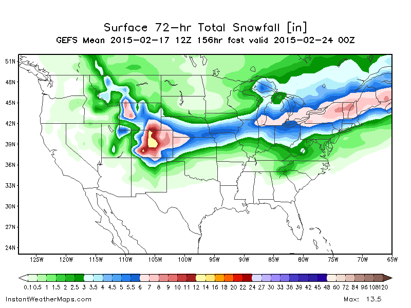
12z GFS Mean if anyone is interested:
 1 point
 -
Warm storm system. Many of us would have to worry about p-type if the 6z GFS were to pan out.1 point
-
Several big hits on the GFS ensembles HR 108 http://mp1.met.psu.edu/~fxg1/ENSPRSNE_12z/f108.gif1 point
-
Beautiful day in eugene all day finally. Felt like an early spring day touching 32 early in the morning and up to 63 this afternoon. Love waking up to sunlight in my room which rarely happens with an east facing window during the winter in Eugene.1 point


This leaderboard is set to Vancouver/GMT-07:00