
Leaderboard


Popular Content
Showing content with the highest reputation on 09/26/20 in Posts
-
Our little airport here in Marshall sits on a bit of a plateau and still hit 32F last Saturday morning. I'm pretty confident that low-lying areas were sub-freezing. I've been here 18 years now and can't remember such an early explosion of color around these parts. Took these today just a couple miles south of the airport:
.thumb.jpg.ee46b25d206d56f55961e98ab2357f67.jpg)
.thumb.jpg.1feabdee2d78474f024e5b678a10a46d.jpg) 3 points
3 points -
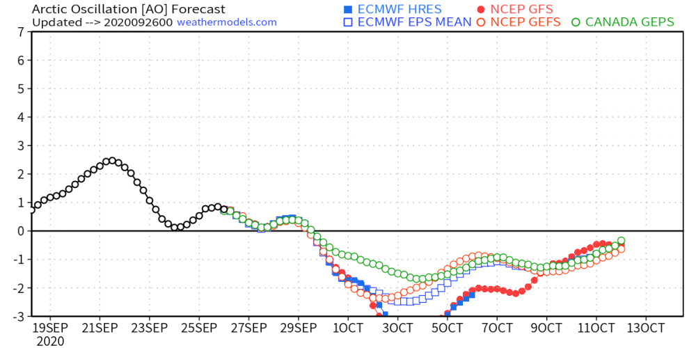
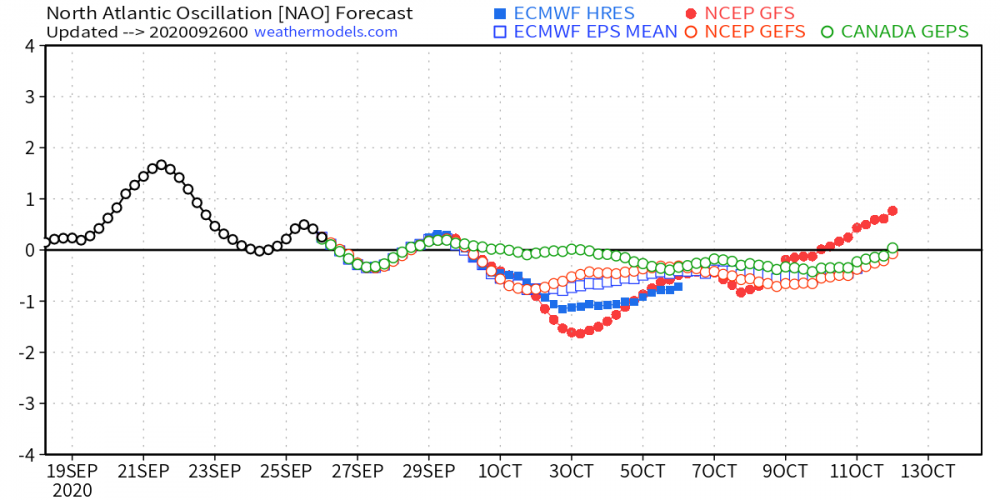
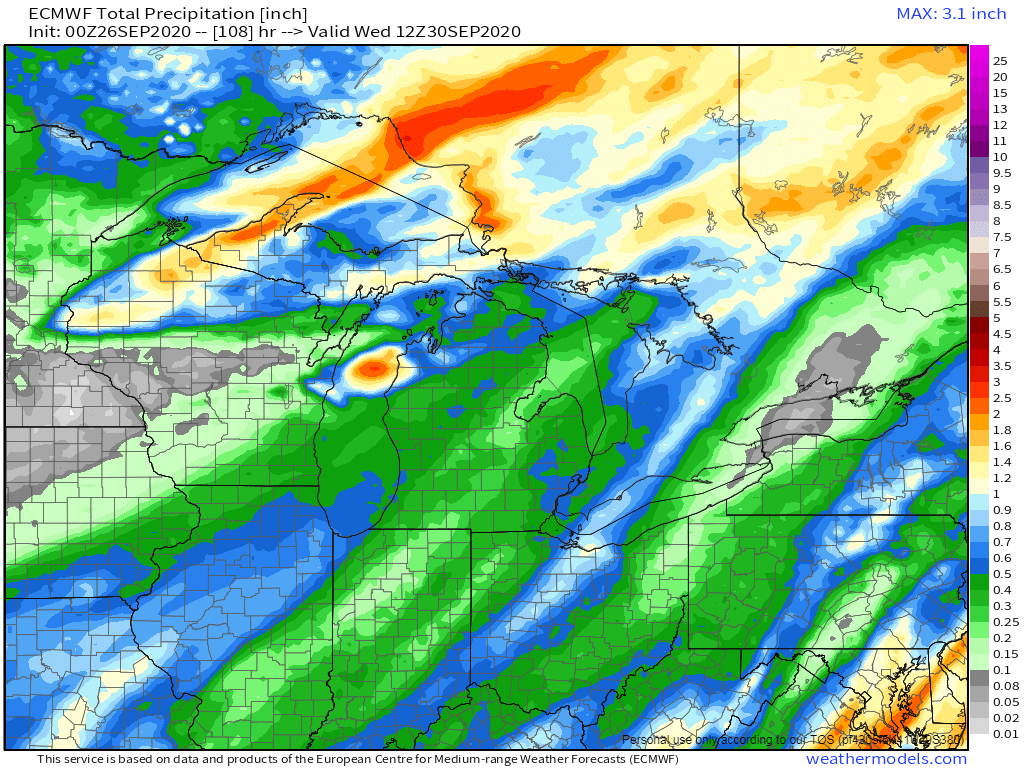
As we wrap up the month of September early next week, we will enter one of the more important months of Autumn that provides us clues what mother nature will have in store as we get deeper into the colder season. Some major changes in our wx pattern are dialing up as we open up a brand new month. Significant high lat blocking seemingly develops right at the start of the month as the new LRC develops, first, way up north in the high lats (good sign) and then trickles down into the mid-latitudes about a week later. What are the models showing??? Let's discuss.... The clues I saw long ago were beginning to present themselves about 10 days ago when I saw the warming developing across Greenland and the northern tier of North America at the 10mb/30mb Strat level. Low and behold, all the models are jumping on the -AO/-NAO pattern. Take a look at the animations below and its really encouraging to me to see that literally ALL the warming ongoing is happening smack dab over North America! It's fascinating to me that as the new LRC develops it is almost like clock work that the atmosphere "snaps" into a new pattern. The CFSv2 has been holding steadfast on the idea of a western US Ridge (+PNA) and eastern CONUS trough-like pattern. Remarkably, this is quite a different pattern we have seen for the month of October in what seems like ages to me. CFSv2 temp/precip trends... On the topic of High Lat Blocking, every single model is picking up on a massive and long lasting Scandinavian/NW Russia Block across the Pole on the other side of the Northern Hemisphere. If this is a pattern that cycles through and one of the LRC's exhibits where ridges will develop in the cold season, look out! Lastly, what about the Snow??? Nature is laying down the foundation way up north, as the sun has set this past week in that part of the world. Ol' Man Winter has arrived and has been awakened. While each run may be different, lately, the CFS has been sniffing out a dramatic expansion of snow cover over Canada next month (Euro Weeklies agree) and quite possibly a big cool down for the lower 48 towards the end of the month. Happy Halloween! North America snow cover extent is trending in the middle of the pack over the last decade...
 1 point
 -
Cold front just coming through. Temp is dropping and the wind is howling out of the north. Lots of blowing leaves also. Goodbye summer, hoping you are gone for good this time.1 point
-
We also fell well short of the expected high temp today due to plenty of clouds. I'm glad it remained pleasant. Southwest Iowa hit the mid 90s.1 point
-
Yep, those LR snow maps are the new "clown maps" of our era but you don't need to look any further than last Halloween to find a real snow swath thru the Midwest. Sooo...1 point
-
Unfortunately, it is all a guessing game. Who will be right and who will be wrong. Fun to see what happens though, that's for sure. Let Ma Nature take care of this. She always does it her way! Hope we get a snowy, frigid one. Right now, the extended outlook has my area for December cold and snowy Lets see how that turns out!1 point
-
I can actually support and/or understand legitimate reasoning if a lot of folks are going to go this route with the East/New England/Eastern Great Lakes in terms of a "hit, then burn out" pattern. Hard to say. The tropics and mid-latitude oceans are going to be a wild card this winter as well as the increased volcanism, etc. Lots of questions remaining. Cold, old-fashioned start is my call and it looks like a homerun for now, but we'll see.1 point
-
Quite the range in the state today.
.png.1c2ccc74a94b7a513368e176be2f6b75.png) 1 point
1 point -
I don’t think we’ll hit record highs today. The smoky skies are back. NWS North Platte said smoke is obscuring the sun and that smoke has made it here. You can’t smell it, as it is elevated. IMG_2413.MOV1 point
-
That snowcover map for Halloween is impressive. Not that I'm expecting it to verify but that is a heck of a nice looking trend.1 point
-
The weather last nite was so wonderful, that we decided to go to an outdoor restaurant for dinner and was very impressed. They had all sorts of food, which makes it a lot easier for those who are nip picky. I have always been Pantophagous, so, I am usually an easy goer when it comes to food. This place has outdoor lighting, which gave it a nice look to it. The people working there were superb as well. I made sure that they received a generous tip, that's for sure. The name of the pl is called "Chapman House."1 point
-
Absolutely splendid outside. Temp is at 64F under sunny skies. Although, a bit hazy and humidity levels today will be noticeable. Different story next week.1 point
-
Fired up an October thread... http://theweatherforums.com/index.php?/topic/3496-october-2020-observations-and-discussion/1 point
-
Woke up this morning to the sound of a SW breeze and mild temps in the mid 60's (64F). Feels like a warm and slightly humid July morning (DP 61F). Looking forward to spending time outdoors today and enjoying this summer-level warmth. My lawn sure would like a decent soaking rain but it looks like the models are drying up a bit for early next week. Anything will help at this point. 00z Euro still advertising a decent rainmaker with the frontal boundary...boy, it sure did trend away from the front-runner/GL's storm....all good, bc its very early in the season and its just nice to see storms energizing in this region which indicates to me this could be one of the hot spots nature is setting up as we head deeper into Fall/Winter.
 1 point
 -
I see the first mention of frost in the grids for late next week. I'll take the cooldown, just wish there was some precip with it.1 point
-
Currently in Marquette. Getting a nice late season severe thunderstorm. Looks just like spring! 63°F.1 point
-
Not the sunny day the models were advertising. Low stratus deck is hanging on tough over N IL. Kinda sucks because I wanted to enjoy some vitamin D!0 points
-
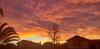
Weather may have been boring, but at least tonight's sunset was not boring.
 -1 points
 -
Low 70s again today. Beautiful weather.-1 points
-
Marine inversion.-1 points
-
Sunset tonight at 4:56 PM, same time as November 3, when we ended Daylight Saving Time. Sunrise, however, is 44 minutes later. Also days are exceeding 10 hours in length again.-1 points
-
No more haze this morning. It's chilly to start the day.-1 points
-
Quite a warm afternoon.-1 points
-
Some places got above 80 F today, but not Downtown L.A so far.-1 points
-
Sunsets are now later than when we ended Daylight Saving Time.-1 points
-
Sunrise tomorrow is the latest sunrise of the year (in Pacific Standard Time).-1 points
-
Despite a sunset of 4:58 PM, Saddleback was still showing a little bit of sunshine today at 5 PM.
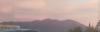 -1 points
 -
So am I. Later sunsets are already quite noticeable.-1 points
-
Last day of the sun setting before 5 PM until November 1.-1 points
-
Weather looks to stay boring and monotonous for a while. Maybe some rain late next week.-1 points
-
Hopefully this month will be full of wonder.-1 points
-
No Omegajinxes plz.-1 points
-
Low of 43 this morning. Nice chilly start to meteorological summer.-1 points
-
Beautiful day.-1 points
-
Not a waste if it helps keep the fire season in check.-1 points
-
Sun angles are way too high to mistake for late September right now, and the landscape is too green. You must not be a true sun angle aficionado if you were able to fool yourself.-1 points
-
Although admittedly today did have a rather late Septemberish airmass and temp profile. Partly to mostly sunny skies and 71/43 here, with low DPs and a cool NW breeze.-1 points
-
Getting quite close to the Fall Equinox.-1 points
-
We are coming to that time of year where the angle of the shadow of a south facing wall on an east or west facing wall is approximately equal to your latitude throughout the day. On the day of the equinox the shadow of the tip of a sundial will trace a straight line throughout the day.
 -1 points
 -
Low clouds have made a return this morning on the last Sunday before the Fall Equinox.-1 points
-
Nice breeze bringing in the clean ocean air in Irvine this afternoon. Although there are still some areas of smoke over the ocean, it should be quite high up by now.-1 points
-
Getting quite close to the sun rising due east and setting due west.-1 points
-
Sun has set on the last day of summer.-1 points
-
Low solar.-1 points
-
Another hot day today, but this is our Indian summer.-1 points
-
Nice blue sky today with good visibility.-1 points
-
Dense fog here this morning.-1 points
-
Apparently an eddy has spun up.-1 points
-
Looks to be hot again next week after a cooler day today. Traditional early fall offshore flow.-1 points
-
Today was the last day of 2020 that had more than 12 hours of daylight and the last day the sun angle reached above 55 degrees. As we've entered the fall, the sun is now setting south of west.
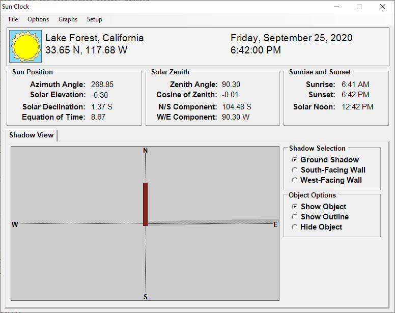 -1 points
.jpg.283fd53cb9b8c14aefab40b7da920540.jpg)
.jpg.659654ccc08836621f2f727a1281055f.jpg)


This leaderboard is set to Vancouver/GMT-07:00