
Leaderboard


Popular Content
Showing content with the highest reputation on 09/25/20 in all areas
-
This falls seems to have an earlier color peak and one of the most vibrant in my memory. But I have noticed over the years that the intensity and timing of fall color seems to be completely uncorrelated with weather conditions with the exception of significant summer/fall drought conditions leading to early leaf change. But, in this case of drought, the color tends to be very dull and drab.3 points
-
Today looks to be another fantastic late September day. I know it has been getting a little dry but hey the days are warm the nights are cool who could ask for anything more? The low here at my house was 53 and at this time it is clear and 55.3 points
-
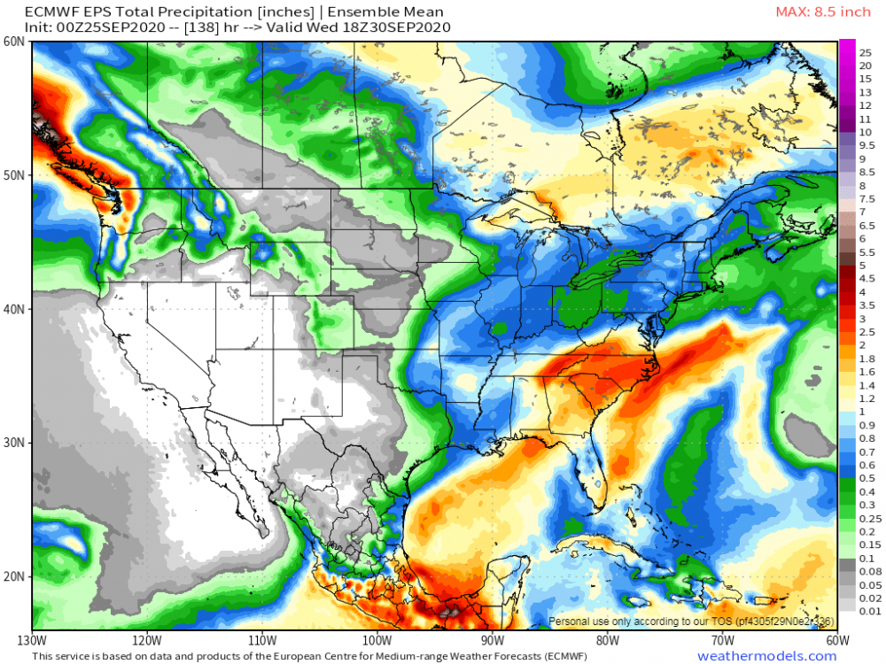
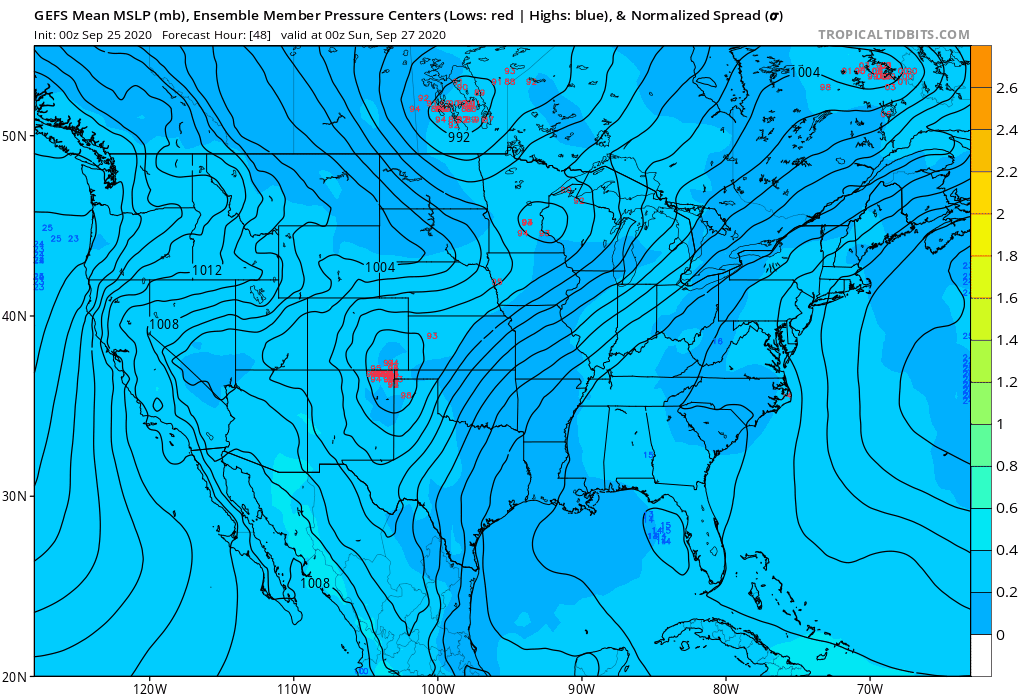
Happy Friday! #TGIF...what a great day to take off of work if you could do so and enjoy what appears to be Summer's last grasp, at least for this region. I think I may even venture off to the beach on Saturday as it will feel like mid-summer with temps pushing the upper 80's (86F) amidst strong S/SW breezes, minimal wave action with an offshore wind. Models are wavering back and forth for early next week. The 00z Euro took a step back while the GFS took a step forward in developing a SLP along the frontal boundary that tracks up into the GL's region. 00z GEFS...classic Pan Handle/OHV Hook being advertised...is nature "flashing" a clue going forward??? As the northern hemispheric pattern literally snaps into Winter up north and a clash between Summer/Autumn down in the mid latitudes, boy, this is quite the way to cap off a month that had it's extreme's across the board. Both 00z GEFS/EPS pretty similar in the precip placement...

 3 points
 -
Glorious, beautiful, magnificent day outside, even though I have not been outside yet, from looking at my windows, it looks awesome. Temps have got to be in the 70s. No time to check, but I would not be surprised if they are at 80 or betta.2 points
-
GRR on next week's cold wave..2 points
-
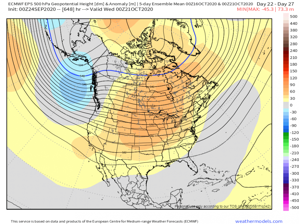
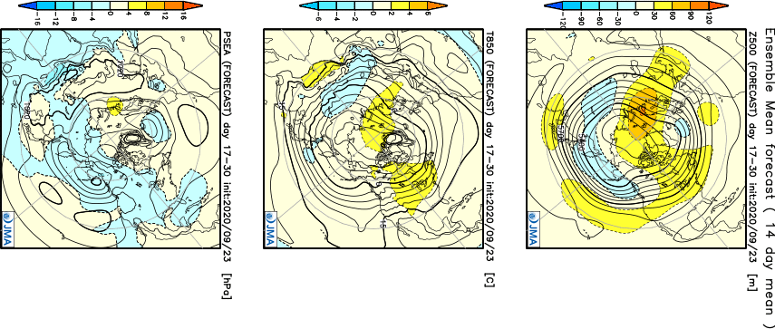
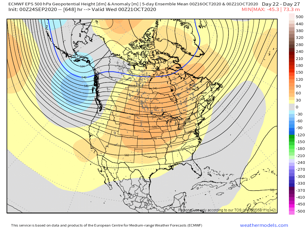
After analyzing both the Euro and JMA weeklies from yesterday, it does look very likely that the eastern CONUS will have the coldest open to October in possibly a Decade believe it or not. All intents and purposes, it appears this Autumn is going to provide the eastern CONUS with a different flavor and what the western Sub has dealt with in recent October opens. You can thank the +PNA which I jumped on a couple weeks ago according to the N PAC pattern and utilizing the BSR as a wonderful long range forecasting method. The SER is will be all but non-existent throughout the month of October from what I'm seeing. The western ridge will prob want to poke into the central and northern Sub sometime mid month allowing a "pullback" to occur during the middle of October. I do see somewhat of a warm spell setting up for a lot of us after some chilly weather to open up the first 10 days of October. The risks that I see to the extent of the warmth across the eastern Sub, is the continuation of a +PNA and -AO/-NAO pattern that may keep the anchor trough nearby as the new LRC develops. Take a look at both the Euro and JMA weeklies for the middle of October and they are both suggesting the ridge to build into the heart of the nation. Another bout of Indian Summer...round 2??? Could be good weather for Fall colors as a lot of peeps on here enter peak season right around that time. Interestingly, while the Euro Weeklies were very warm towards the end of October and early November, it's control run and the ensemble mean are sniffing out some possible snow by the end of October but esp early November. Notice how over the next 45 days the Euro Weeklies are indicating an expansive snow cover over the central/eastern part of Canada. "If you build it, thy will come"...nature providing us signs that the Hudson Bay Vortex will be forming early and often this Autumn up north. How far it displaces is the question, if it does at all come November and potentially...Decembrrrr??? I got some ideas but won't throw them out just yet, but I will predict that WxBell will be making some adjustments, prob BIG adjustment to their winter forecast. The East will have a winter this season.
 2 points
 -
I was thinking the same thing over here while taking a walk the other day. It does seem like that early cold spell in Sept really kicked things off and the cool nights and warm/dry days are certainly helping along with plenty of sunshine. We may be having a banner year for fall colors this year. I know up north, they are reaching their peak season and some gorgeous colors are showing up in the Northwoods and Arrowhead of MN. https://www.travelwisconsin.com/fall-color-report This weekend is shaping up to be a fantastic weekend for the outdoors across the region.2 points
-
Excellent pics Jaster!2 points
-
That already happened....2 years ago1 point
-
Very sweet looking maps Tom. And with the SLP forming in just 2-3 days not a fantasy range deal. What are temps like during the rain over our way? Many good things so far this early autumn. Absolutely played a round of golf yesterday and can't get enough of this late summer perfection.1 point
-
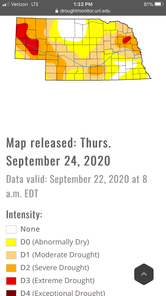
Lack of moisture is sure concerning on this map for my region of the Central Plains.1 point
-
Beta decided to creep up all the way into mby yesterday. No rainfall, but, its cloud shield definitely came by. Skies were mostly cloudy for a couple of hours as most of the hvy rainfall was way south of SEMI.1 point
-
Tim controls my ability to enjoy the weather. Words cut like a knife.1 point
-
Our little airport here in Marshall sits on a bit of a plateau and still hit 32F last Saturday morning. I'm pretty confident that low-lying areas were sub-freezing. I've been here 18 years now and can't remember such an early explosion of color around these parts. Took these today just a couple miles south of the airport:
.thumb.jpg.ee46b25d206d56f55961e98ab2357f67.jpg)
.thumb.jpg.1feabdee2d78474f024e5b678a10a46d.jpg) 1 point
1 point -
Well, a roasty August and a few hot days in September did it. DEN is at 74 90+ days this year, a new record. August was the warmest on record. Thanks to the record cold snap early in the month, September will likely end up just a bit above normal.1 point
-
The average high for Iowa City on October 1st is 70, Euro is showing temps in the low to mid 50s. That sucks. I want to hang on to the warm weather as long as possible. Even with this cold we aren't going to see snow, so I'd much rather keep highs in the 70s until about Thanksgiving when we have real shots of snow. I don't mind a cool day here or there, but that trough means business on the Euro, so that's a multi day cool down coming up.1 point
-
I love blizzards too. Hoping to get a legit one at some point this winter. A lot of trees have been cut down in my area in the last 1-2 years (more were just cut down a week or two ago) due to disease or other reasons. Haven't really had a good chance to test out the blowing/drifting potential in a big storm because there haven't been any big snowstorms during that time but it is noticeably windier than it used to be given the trees that no longer exist.1 point
-
1 point
-
Potential high tomorrow of 97. Record high is 98. A/C continues to work overtime. It is really just comical that we are pushing 100 on September 26th. The drought is only getting.
 0 points
 -
This will be next week y'all....."Get Ready."0 points
-
You can control our weather Stop driving cars Kill off all cows Stop using electricity Never ever vote Republican again-1 points
-
If Tim controlled the weather he would not have needed to dig his family truckster out from his driveway when 50 feet of snow fell the night before they were flying to Hawaii a few years ago.-1 points


.jpg.283fd53cb9b8c14aefab40b7da920540.jpg)
.jpg.659654ccc08836621f2f727a1281055f.jpg)


This leaderboard is set to Vancouver/GMT-07:00