All Activity
- Past hour
-
 Another line of thunderstorms moved through overnight adding .65 inches, my storm total now sits at 1.75 in. More storms are lifting out of NW Oklahoma and SE Kansas and will be here later this morning. I'm hoping I can continue to get the big rains without getting my house blown down this weekend, an additional 3-4 inches look possible with severe threats the next 3 days. I believe tonight and Sunday will be my biggest threats for severe weather.
 -
 So far 0,30” here, once again in just an unlucky spot in Southwest Omaha… thankfully this event is far from over.
 - Today
-
Models have continuously overdelevoped ridges in the 120-240hr range over the last couple months. I doubt tonight's GFS and CMC are starting any new trend.
-
With today's underperformance, KSEA exactly doubles its April 2024 rainfall total, adding another 0.43" to the bucket and filling it gently to an even 0.86"... Pending some stray stratoform rainbands over the next day. Tomorrow will clear earlier than modeled over the Sound with a mostly-dissipated occlusion front overhead and weakly negative low level lapse rates. Any residual stratus should be digested mighty well by that steamin' late April sun, mixing skies into hazy sunshine before noon. I'm going for a gutsy 64/47 day at KSEA. Might even get a bit muggy, some CAM's have dewpoints pushing fifty in the favored sheltered areas, despite what I claim to be too much modeled cloudcover.
-
Are these some of Jesse’s burner accounts? A little over a 1/2” of rain so far. Kind of underwhelming
-
Went over an inch hours ago here! 1.39" on the day currently!!
-
.96” now! Will be a race against the clock to see if we can hit 1” by 11:59.59!
-
 For my area we are under the slight for today. We will have an initial round of decaying storms this morning near sunrise, with CAMs showing some supercells popping off in the afternoon. There is little agreement on exactly where or when, other than that it will probably happen near or east of Tulsa. So I don't actually expect a lot of activity here today. It looks like a better bet of dry line convection on Saturday afternoon, and this happens in a jacked out parameter space. Still a little early to try to guess exactly what this ends up looking like but the ceiling is high and I expect a moderate to come out on tomorrows outlook for Saturday. Saturday into Sunday either over or just east of me the initially discrete storms merge into a line of heavy rainfall so that is also in the potential mix.
 -
It's worth noting that the rainfall forecasts from the NWS are dictated by WPC, not the local offices. Local offices can make changes to WPC for days 1-3 providing they can get their neighboring offices to agree to changes. Additionally, its worth noting that WPC has a chronic high precip bias for amounts over 1" or so. So when you see big rainfall forecasts a few days out, it's probably going to diminish as it gets closer.
-

April 2024 Weather in the PNW
Rubus Leucodermis replied to Tyler Mode's topic in West of the Rockies
0.97" since midnight, 1.05" storm total IMBY. -
.91” so far on the day.
-
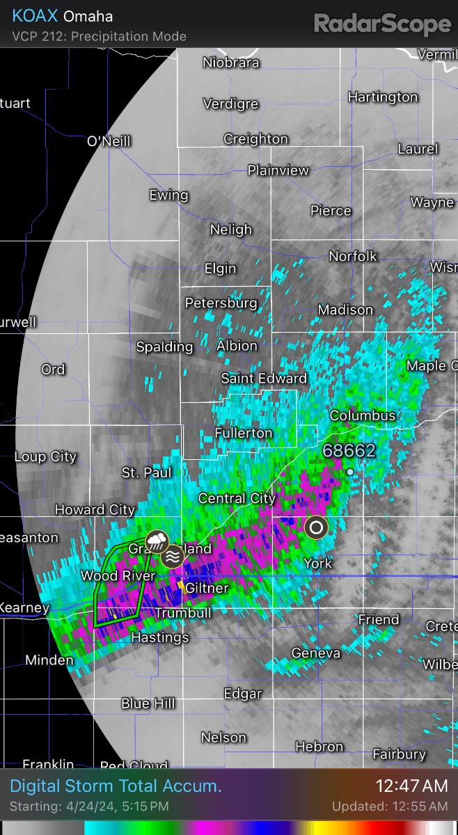
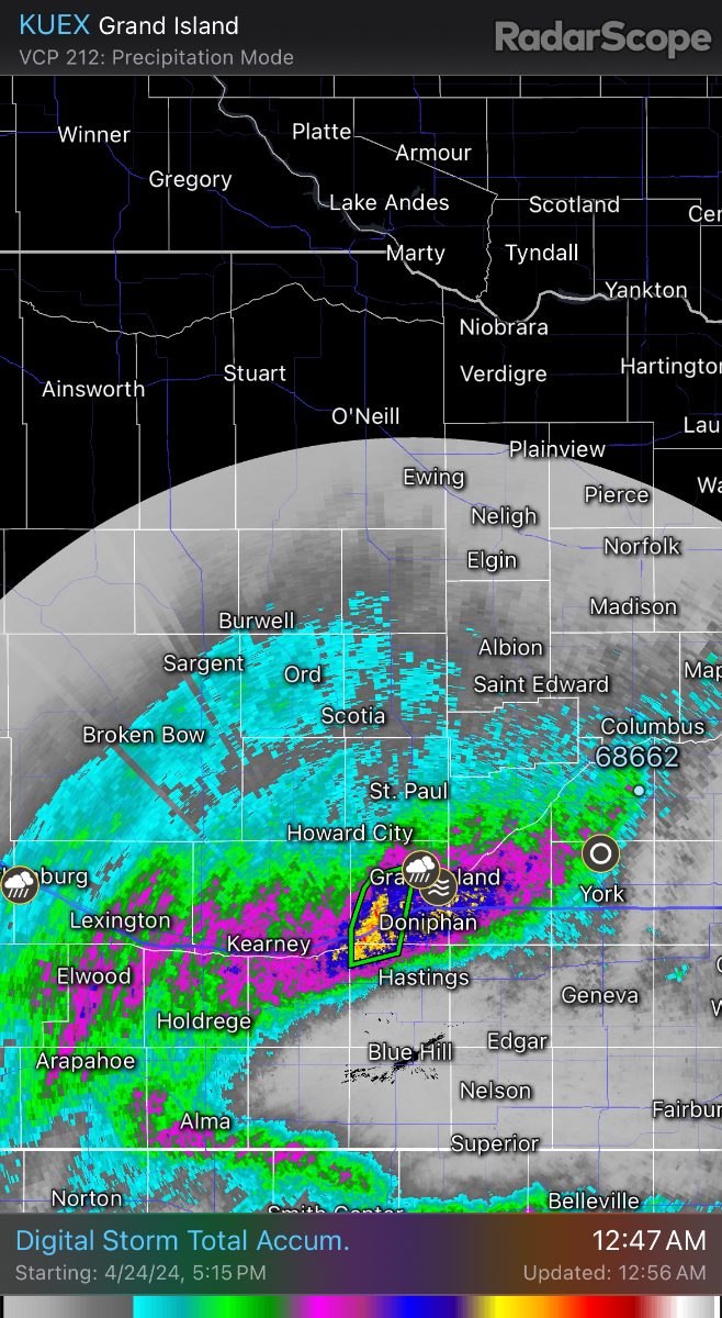
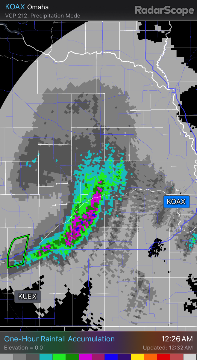
 Both these models done a really good job of picking up on the heavy band of rain tonight, almost spot on. Going right through my area, I thought we would get dry slotted tonight! I’m closing on 2 inches!
 -

April 2024 Weather in the PNW
Sunriver Snow Zone replied to Tyler Mode's topic in West of the Rockies
Down to 39 now, had .07" of rain fall this afternoon. It was a pretty chilly day, only got up to 47. -
39 currently, 47/36 day with .07" of precip. Not sure why everyone is talking about politics right now on the weather thread, maybe go to the politics thread.
-
 Looks like we have one more gloomy day left.
 -
April 2024 Weather in the PNW
Sunriver Snow Zone replied to Tyler Mode's topic in West of the Rockies
Salem is a cool outlier because there's less urban heat there, right? Or is the station not working properly? -
April 2024 Weather in the PNW
Sunriver Snow Zone replied to Tyler Mode's topic in West of the Rockies
DO NOT LOOK AT THE 00Z GFS @Jesse @Cascadia_Wx @CascadiaWx @Cascadia -
Bump, cuz I can!
-

West Coast Sports Talk and Other Banter
Front Ranger replied to Anti Marine Layer's topic in West of the Rockies
They stole the Laker's soul, burned it, and then flushed it down the toilet. -
That was the point, sir. Although PDX will still be the outlier on the opposite end, with a warmer anomaly than anywhere else. Should end up as a pretty average month overall.
-
Including boys in a girls bathroom in school is basically asking for TROUBLE Biden administration finalizes controversial Title IX rule to ‘redefine’ sex - Washington Examiner
-
I got 1.1 inches with this first round of rain, more thunderstorms expected towards morning.
-
April 2024 Weather in the PNW
Sunriver Snow Zone replied to Tyler Mode's topic in West of the Rockies
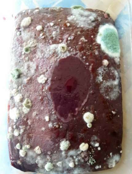
Oh look, there's a new page now! Made some dessert to eat tonight, I noticed some weird stuff on the cake, I wonder what it is... looks delicious, kinda like cotton candy. It wasn't there 2 weeks ago.