
Leaderboard


Popular Content
Showing content with the highest reputation on 01/27/15 in all areas
-
Thanks. The models are a mess trying to figure out next week. Beyond that, who knows. February could easily have some good things in store. It's very unlikely it will be a repeat of January.2 points
-
Great for Boston, and the rest of New England. Meanwhile lots of people in NYC and the western subrubs are asking what all the hype is about. I suppose I take some comfort knowing that somebody on the east coast got screwed2 points
-
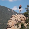
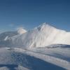
Well this upcoming pattern might shake things up. Just to give you a comparison of how bad this winter has been in the mountains. I took this photo from the Summit of Mailbox Peak (near 5K) just outside of North Bend at the beginning of January. There was probably a couple of feet of snow. http://www.wta.org/site_images/trip-reports/2015/image.2015-01-01.1558727226/@@images/2253f429-9c46-4614-836b-99c68a52d8a2.jpeg I have never seen it this bad in late January (except for last year). This is really reminding me of the 04/05 winter season. This is what it looks like now: http://www.wta.org/site_images/trip-reports/2015/image.2015-01-26.4149284810/@@images/35d6aeee-08f9-4723-bb75-11deac313b12.jpeg2 points
-
Kind of what I'd meant to suggest, if by and with the "more generic" idea, my more general projection here being more in line with the idea that one may. Depending on what's more upstream consolidated and in place more northward more main cold wise at the time. — Alaska's colder conditions over the recent past few days being a good sign generally, for something more significant at all to move south between the Far West and more where you are. .. And more "broad-based", with whatever cold starting south doing so with a gradually more stepped up movement eastward, and so "more zonally", more clearly stated.2 points
-
Seems like the major models are getting a handle on the increased QPF. Will be interesting to see if the trend continues of increased Qpf.1 point
-
Two years ago at this time I was driving home to feed my dogs after spending the day at Salem Hospital, with heavy wet snow falling. Happy birthday to my beautiful little girl.1 point
-
CAN 138--
 1 point
 -
Starting a Thread for this system....1 point
-
10:1 ratio map of Iowa
 1 point
 -
Yeah just jelous seeing those 1'+ totals just to the north lol.1 point
-
Isn't this storm happening around the same day as the GHD blizzard?1 point
-
On top of that, with the HP to the north it will create a cold wind off the lake for over 24 hours. This set up should create a lot of lake enhancement in WI/IL.1 point
-
So....did this run phase the northern and southern streams earlier than what the runs from earlier today showed?1 point
-
Imagine if you can get that thing to phase/develop earlier...1 point
-
lol!! You should be a politician or a comic!1 point
-
This storm is looking impressive...back to back Majors possibly???? Wow...10-20" showing up in SE MI/NW IN/NW OH...1 point
-
D**n. Time to start a thread I think1 point
-
Still snowing after that frame...1 point
-
Nashua, NH 33"+ at 7:30. About an hour NNE of Boston.1 point
-
That is honestly like a dream run. Just keeps snowing and snowing for 24+ hours. 12+ in Iowa, 8-10 for Chicago area. 6-8 for MKE/S. WI1 point
-
Can we please lock in the GFS? Widespread 6+ amounts for a lot of posters here1 point
-
Yeah...it is some consolation knowing this month hasn't been terrible just because we live in a bad climate. It is simply a terrible pattern on a very large scale.1 point
-
Much better subsurface profile under the ENSO regions than what we have seen. If we can get through this WWB without any major new downwelling Kelvin wave we may manage to escape a re-intensification of the Nino yet.1 point
-
Pretty nice day in Bend. Mix of sun and clouds and fairly warm. Looking for houses, hopefully I find my new home here soon!1 point
-
Pretty crazy differences again in the models today. The UK and Euro are incredibly different from the GFS from day 5 on. The ensembles overall favor a more GFS-ish solution, but so much spread, a lot of possibilities still on the table for next week.1 point
-
Euro looks colder but worse. It looks pretty close to PNW lowland snow but very dry.1 point
-
It's also looking colder for the Plains/Midwest with temps in the mid/upper 20's during the event...1 point
-
Huh. The UKMET is showing something interesting for next Monday. http://img.meteocentre.com/models/ukmet_amer_12/GZ_D5_PN_144_0000.gif1 point
-
Turns out the snow totals in New York City itself were not as impressive as originally hyped up to be. Just under 8 inches recorded at Central Park, and 11 inches at the airport. Most of the heavy snowfall was concentrated to the North and East. Sounds like Long Island got some pretty good totals. The suburbs just west of NYC only recieved 1-3 inches. Lots of weenies probably mad this morning.1 point
-
So much of the complaining though is regarding the models, and the recent Euro bust justifies these complaints. They have been worse than normal I think this year.1 point
-
Agree 100%. All the complaining on the board has become tiresome. 6.5 inches in central park as of 8:00am. Storms are unpredictable1 point
-
I love that wxbell now has the uk precip maps out to 144 hours. Here is the uk snow totals for the weekend.
 1 point
 -
I cant wait for this 65 degree garbage to go away til may. Just rediculous to feel the warm today in winter.1 point


.thumb.jpeg.e3014abf99ef08a9f9ac2c0cd31b485b.jpeg)
This leaderboard is set to Vancouver/GMT-07:00