
Leaderboard


Popular Content
Showing content with the highest reputation on 02/28/15 in all areas
-
Well, we can let 2015-16 and 2016-17 be the judge of that I'd expect something pretty radical in one of the next two winters. Likely not as historically good as this winter has been poor, but some semblance of balance nonetheless.3 points
-
You're coming off like a d*** with all these posts like this, dude. It's been a really, really boring Winter, so it's only natural that people would start tracking and analyzing when the first chance for colder and more active weather in a while showed up in the models inside day 7. It's not like people have been posting ridiculously over-the-top analysis either. Seemed pretty level headed mainly along the lines of "the first mountain snow in a long time and the possibility of lowland snow if everything went right." It's been obvious that things aren't "going right" for several days now and thus there have been barely any posts about it except for your continued posts about how boring the pattern will continue to be. Just stop.3 points
-
To me the whole casino gaming analogy doesn't really hold water. Granted the whole "we're due" thing is total BS, but it's BS that at least is partially based in reality. With a roll of the dice, each roll is entirely independent of the other without exception, all things being equal. With weather, the past does effect the future on both a dynamic and practical level. We have a fairly good understanding of the push/pull of things and this affords us the ability to see the future to some degree, as opposed to a dice roll which can only be predicted for entertainment purposes. Statistics will always win out eventually while the weather actually dictates its associated statistics.2 points
-
Looks like snow all the way down to K-Falls. I hope my Dad waits a couple hours before heading out.2 points
-
Woke up to about 4 inches in SW Bend, took advantage of the upslope flow. Redmond got nothing and NE Bend had an inch or two.2 points
-
.. Whoever's brother's, mother. (?)1 point
-
I think the years following our warmest winters regionally tend to have a higher than average propensity for severe cold/snow in the region. This is obviously relatively arbitrary and it's obviously not completely scientific, but when we're talking about truly top tier warmth there overwhelmingly seems to be some next year payback. The absolute warmest winters for the WA/OR/ID region prior to this were: 1. 1933-34 2. 1991-92 3. 2002-03 4. 1957-58 5. 1980-81 6. 1952-53 7. 1939-40 8. 1994-95 9. 1977-78 T-10. 1982-83 T-10. 1969-70 So the following winters were 1934-35 1992-93 2003-04 1958-59 1981-82 1953-54 1940-41 1995-96 1978-79 1983-84 1970-71 Of those 11 winters, only 1 of them (1940-41) lacked either a major arctic period or major snow event for the western lowlands. That's a much higher percentage of hits than we're used to seeing historically. This turnabout becomes far less noticeable the more moderate our blowtorches become. We've followed many modestly warm winters with complete mediocrity the following year. So obviously it's arbitrary and there's a point where the correlation, however small, is no longer worth pointing out.1 point
-
Would love a south shift off the GFS, probably not in the cards.1 point
-
Vio-la. ... I've just gone ahead and posted it. http://www.proxigee.com/post-923-0-57705600-1425183111-90degs_r.gif .. So is this south of town then. ? — Looking west looks as if. WNW.1 point
-
That said the odds of having a winter as terrible as this winter are lower than the combined odds of having an average or above average winter; either of which would seem amazing from the perspective of any of the past three winters (at least up this way). I think the gambling analogy for this would be quit while you're ahead (i.e. you just rolled three 1's in a row). Of course the climate does go through various decadal cycles so over shorter periods so the tendency might be higher for a certain atmospheric configuration depending on the point in the cycle; but, over time, climate (the average) will be achieved, albeit with smaller tendencies for one pattern over another due to longer running change (i.e. the warming of the planet).1 point
-
Check on LOT's FB page1 point
-
Still hoping for a rainy March so we can get a better April/May? I know you want snow in the Mountains, but this Winter certainly seems like an example of how "the other shoe must drop" theory of climate is largely BS.1 point
-
Be happy you got a whopper of a storm, even if it was pretty much the only excitement of the winter. Fargo and Minneapolis would love to have seen a 6" storm (the snow lovers in those cities, that is).1 point
-
Warm and ridgy is the new default.1 point
-
I'm not saying "you" were wrong Tom, I'm just saying the model you showed I thought was for a sustained pattern of southwest flow with a southeast ridge for the month of March, I thought I saw a monthly model run, yet you just showed models that aren't showing that too be true. They've corrected back to the same pattern we've been in most of the winter. I apologize, I must not be remembering that that was only for a couple day period. Sorry I was WRONG. Sure I see the change coming with the warmup in 10 days and right now for the next couple of days this storm moving through is in a southwest flow, but apparently that's not going to last and we are going to go back to the same pattern we have been locked in. Stop being so defensive Tom, you don't make the models, you're just showing them and I was just observing what the models have been showing. You're last sentence stated exactly what I was trying to say, there's not going to be a flip in the pattern that lasts longer than a couple of days. Sorry if it seemed like my "prerogative". Geesh1 point
-
Just got a text from my Dad. He said 4" at his hotel in Bend.1 point
-
You are really negative when it comes to snow. Holy crap.1 point
-
- Here where I am more south, …. — Central Northern Sierra more ridge-land front type foothills, stronger orographic challenges both West and South facing. i-5 north.jpg .. From about 4:30pm or so through near to 8pm, we had some general instability set up type cumulus, darkening steadily, with gathering increasingly better: first yielding some virga more still earlier on, before then showing first some, to then increasingly more lightning through to and then more after main sunset, all before finally yielding some amount of more decent strength semi-hail and rain, from maybe 7:30 to 9 pm. http://classic.wunderground.com/weatherstation/WXDailyHistory.asp?ID=KCAPARAD2 http://www.atmos.washington.edu/weather/sat.shtml1 point
-
Just started snowing here in Bend. Beginning stick off the roadways. Hopefully wake up to 3-4 inches tomorrow.1 point
-
the cfsv2 weeklies have been pretty awful recently.1 point
-
First time there's been snow on the ground up at Hurricane Ridge in a long, long time! http://www.nps.gov/webcams-olym/current_ridgecam.jpg?20151271146321 point
-
If its not going to snow, we might as well go big. Hasn't hit 60 at my location since November.1 point
-
Environment Canada says I'm supposed to reach a low of 21 Tuesday night into Wednesday. #AGW #GlobalWarming1 point
-
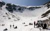
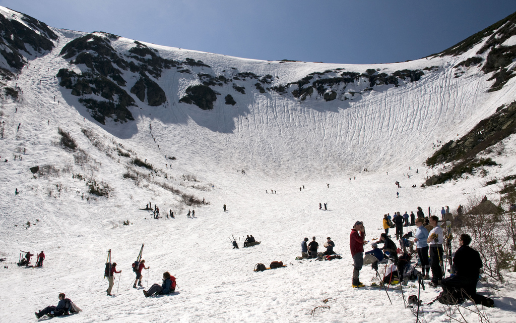
Yeah, Bachelor has been lucky. I'll probably ski below Camp Muir later this spring. I was pretty high above Paradise hiking in the snow last June with tons of people skiing past me (and some marmots) in some pretty carvable snow. It brought back good memories of skiing Tuckerman's Ravine (below) in late May growing up.
 1 point


This leaderboard is set to Vancouver/GMT-07:00