
Leaderboard


Popular Content
Showing content with the highest reputation on 02/19/24 in all areas
-
God’s promise
 9 points
 -
8 points
-
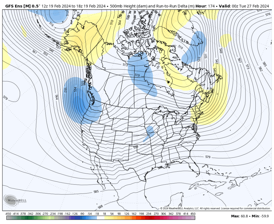
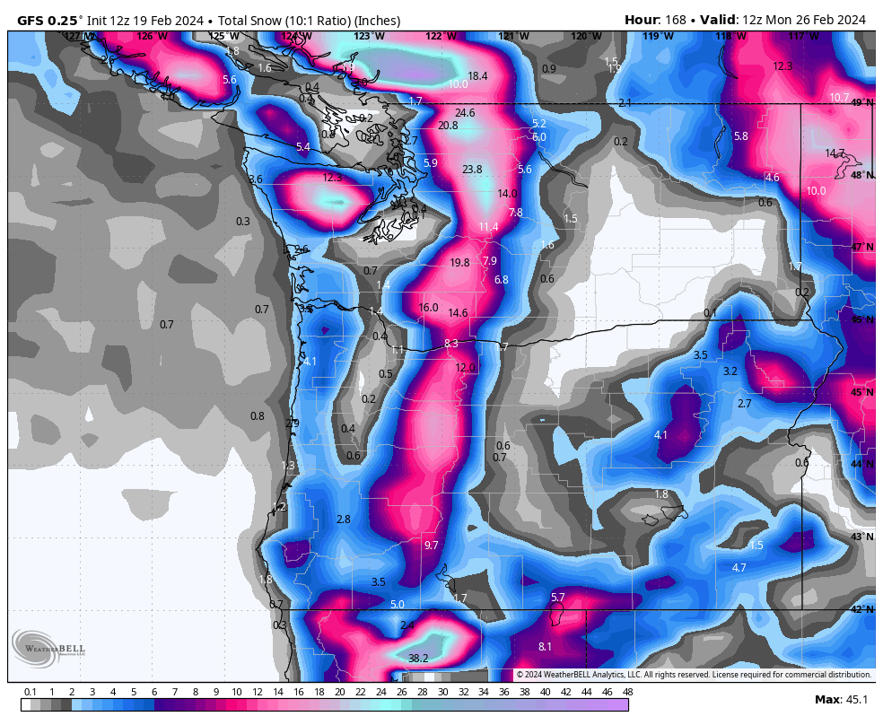
Gfs consistent with nice pscz.
 7 points
 -
Gem looks like it partially caved.

 6 points
 -
Beautiful
 6 points
 -
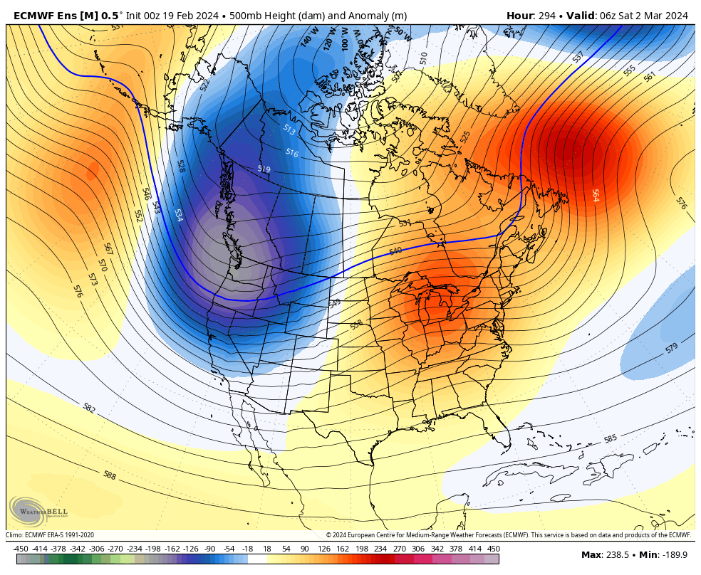
18z Gefs doubled down on first trough strength. Others models aren’t close.
 6 points
 -
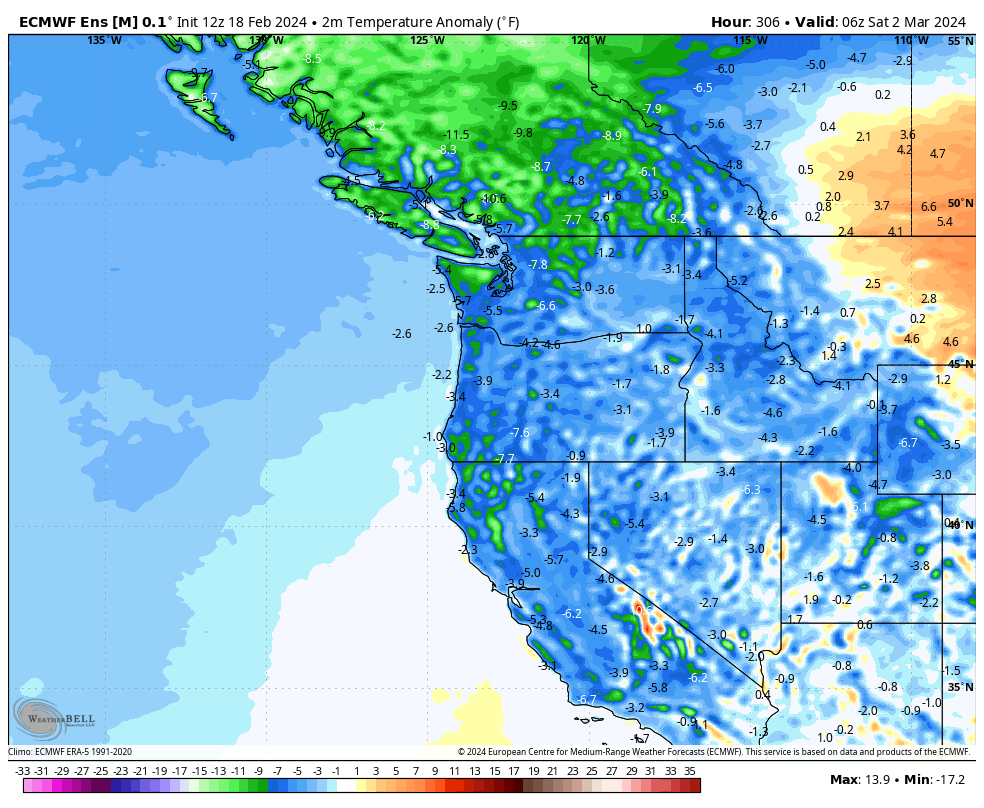
A legitimately strong pscz would drop temps into low 30s like a hammer with the cold upper level temperatures6 points
-
EPS was quite a bit better than the operational. 18z GFS is a step in the right direction.6 points
-
Thirty-one years ago RIGHT NOW a residual Arctic air mass and a now suppressed jet system were combining over the Willamette Valley producing HEAVY SNOWFALL. A reminder that 30+ years ago, lowland snow during cold weather was “almost inevitable.”
 6 points
 -
2015-19 Tim was an absolute saint next to 2006-12 Tim. The combination of much warmer spring/summer weather and him no longer being such a recent SoCal transplant boob really allowed him to morph into the beautiful soul he is today.6 points
-
Ready for April 18th 2008 to commence again!5 points
-
Usually always happens
 5 points
 -
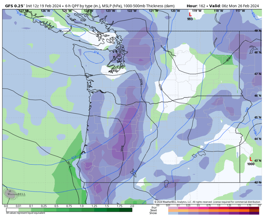
18z sticking with a chance of meaningful CZ snow Sunday night North of Seattle.
.thumb.png.201e12938e51493b4689c00ee8c850ee.png) 5 points
5 points -
Got to like it.
 5 points
 -
Pscz showing up again.
 5 points
 -
Those outlying GEFS members on the 0z might have been onto something. This is getting good.5 points
-
I have my interior thermostat set at 70 degrees. It's crazy how much warmer it feels inside when it is warmish outside. If it is 30 degrees outside with obviously low dew points I need a warm sweatshirt inside at 70 degrees. If it is 55 degrees and raining, I am warm in just a t-shirt despite the inside temperature being the same. Dew points are a huge factor even when it isn't 90 degrees out.5 points
-
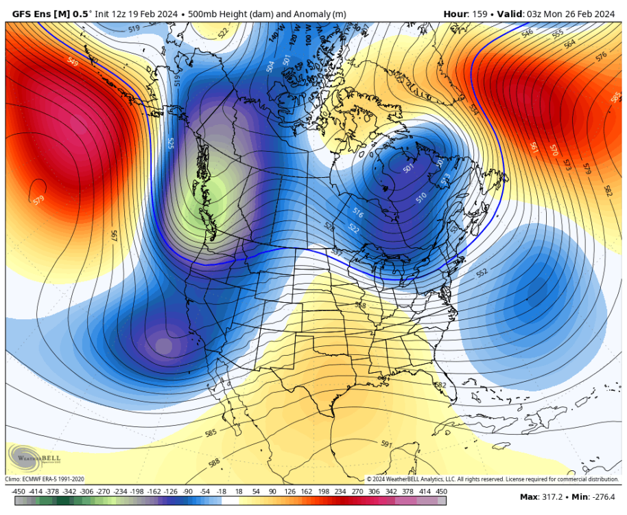
Arctic air a lot closer this run4 points
-
Way more ridging to the west
 4 points
 -
I would sure love to see the other models trend toward the GEM. A seamless transition from the first to second trough. Really looks good at the end.4 points
-
Massive snow above 2k feet4 points
-
GEM is incredible. Almost there with the first trough and then SLAMS the region.4 points
-
The 18z EPS was a notch sharper with the trough.4 points
-
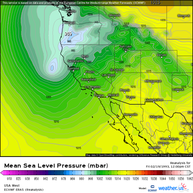
I agree. But that map shows light snow in Portland with onshore flow and -4 850mb temps and surface temp of 39 at that hour. Just frustrating you can't rely on those precip type maps at all anymore. They used to be better.4 points
-
Pretty early evening sky out there.
 4 points
 -
It kills me how overly generous the WxBell maps are with snow. That pattern would bring snow in the CZ, but most of the rest of the area would be rain below 1,000 feet or so, yet this map makes it look like 98% is snow. This is temps at that time:
 4 points
 -
4 points
-
Day-um!4 points
-
5+ feet of snow across higher areas of both the WA and OR Cascades. Would be huge for the ski season which has been limping along for most of the season.
 3 points
 -
Big dump for the mountains.3 points
-
That's pepto IMO. It's late February/Early March.3 points
-
6 years ago today it was quite cold out!
 3 points
 -
It’s raining. Kids wanted to ride their scooters. It was against my better judgment but we did survive.3 points
-
My rule is -6 850s with a C-Zone is always good enough for snow.3 points
-
I’d take this verifying over taking a chance the pattern lasts longer…3 points
-
And temps will end up cooler than advertised as we near the event…Usually always happens!3 points
-
The sun actually feels really warm out there right now. Don’t tell Jesse, but it felt good.3 points
-
3 points
-
Getting really good!3 points
-
More goodness.
 3 points
 -
3 points
-
Right here. It snows during the night and it's around freezing with cold mid levels.2 points
-
I like the GFS in that it is so dynamic with the first trough. It's kind of a classic 4-8" late winter/early spring snow maker for this area. A big morning snow dump next Monday and then probably some convective snow showers in the evening. The GEM and EURO are improving with the first trough, and show a better pattern for extending the active weather.2 points
-
The GEM is just a better more suppressed version of the EURO.2 points
-
It's just not. The GFS is clearly the best combo of cold/juicy with the first trough. I can see why you might like the EURO version better, but obviously after the initial trough is where big differences start emerging.2 points
-
Genuine snowfall for the EPSL. Temps below freezing.2 points
-
2 points
-
7 straight wins. Although my parents' neighbor is from Tacoma and a proud UW Seattle alum and told me that he can't support seven year old's Cougar fandom lol. I should have asked him if he misses the snow, having been in CA the last twenty years. We'll see if there's any convection here in CA tomorrow then back to KGEG on Tuesday.2 points
-
Maybe... but doesn't seem like an arctic air pattern. At least not yet. But I think cold onshore flow is the best situation right now anyways for snowpack.2 points
-
Run comparison
 2 points


.png.7fb0d3bb146faf31e4898028e09ab5da.png)


.thumb.jpeg.e3014abf99ef08a9f9ac2c0cd31b485b.jpeg)


This leaderboard is set to Vancouver/GMT-07:00