-
Who's Online 20 Members, 1 Anonymous, 179 Guests (See full list)
-
Activity Stream
-
4411
March 2026 Weather in the PNW
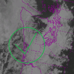
The CZ was a thing of beauty yesterday. Clear skies from Marysville to Bellingham and from Seattle to Olympia with downpours, hail, and wet snow in between. Everett picked up 1.12" of rain yesterday including 0.74" in 6 hours. Was our wettest day of the entire season since we were shadowed from the AR's- 2
-

-
687
March 2026 Observations & Discussion
Don't think I'll pull it off here, but there could be places just south of me (Kankakee?) that pull off a 50 degree spread between the high and low today. -
4411
March 2026 Weather in the PNW
Actually the NW is more likely to burn if you have constant warm ARs 24/7 that deplete snowpack and get the fuel overgrowth, then you flip to a hot and dry summer. But anyways the upcoming pattern is decent. Some sun, some clouds, and most importantly pretty chilly. That means mountains may seem some occasional snow. Like the CZ delivering to Steven's Pass. -
4411
March 2026 Weather in the PNW
I know lol. I’d want a good balance between sun and rain going into the summer but that almost never happens anymore -
4411
March 2026 Weather in the PNW
Not exactly true. 2022 was pretty wet and chilly til June. Then the switch flipped and we were hot dry and eventually smoky til October.- 2
-
-