
Leaderboard


Popular Content
Showing content with the highest reputation on 02/18/15 in all areas
-
You hit the nail on the head. A big problem with humans in general is we think we're a lot smarter than we really are.3 points
-
CPS just closed schools for Chicago...temps are falling like a rock!2 points
-
GGEM with ratios: http://www.uswxforums.com/forum/uploads/monthly_02_2015/post-4070-0-98892400-1424277970.gif2 points
-
Speak for yourself in your own back yard. If you lived in the southern Plains/Midwest, you got a significant winter storm. It's pretty selfish to say that since this forum covers a huge amount of real estate in the central CONUS. Everybody has their choice to post on here. You don't need to come on here and tell someone that it is a bad idea to issue a new Thread on a storm system that has "real" potential and since we are only 3-4 days out. It also "cleans" up the February Discussion and keeps posts separate from the general discussions.2 points
-
Although, it could be said certainly, equally, that with this paradigm at the ready, set to reel out at the hint even of anything more cautionary (even pre-cautionary.), that someone doing a best effort and as fairly as they're able to evaluation and assessment, and reporting what they find, also might be thought of as such. Or in other words, with this more "sweeping" (if "naily, on the heady") "generalization", adopted too stringently, you might just tend to overlook something of more value connected to the ongoing argument.1 point
-
Been awhile since we've seen this. Of course, everyone would have loved to see this a month ago, but still good to see the return of western troughing. 12z Euro ensemble: 18z GFS ensemble:1 point
-
Actually, I believe you were asking just yesterday if the models have "backed off the pattern change yet"? The answer is still no.1 point
-
I'm not an AGW skeptic. I've made that abundantly clear many times on here. AGW has happened and continues to happen, slowly (though the climate has always been in a state of flux, sometimes slower, occasionally faster). However, I am skeptical of catastrophic AGW. I see a lot of bad science, influenced by politics and other motives there. As well as general media scare-mongering. As far as what I emphasize, I think I'm more balanced about that than I used to be. I do draw a distinction between weather and climate/climate change, so maybe some confusion lies there. But "agenda"? No more than everyone else on here who has opinions.1 point
-
Your intelligence is yours to do with as you please. It gets tiresome in these discussions where you reflexively just fall back on pulling the big bad wolf card. The PDO clearly has ties to ENSO, and we know ENSO's phase often times is closeIy tied to global temperatures. ENSO in other words would be a better scapegoat. The PDO is a resultant.1 point
-
He was trying to claim that he didn't truly get burned in 2012 because the major snow mostly occurred "down the valley."1 point
-
My old stopping grounds and place I vacation to in the Arrowhead of MN had a high temp today of -11F. Going winter camping near there in mid March. The colder the better for moving in deep snow--- http://w1.weather.gov/data/obhistory/KCKC.html1 point
-
Or maybe, the global circulatory regime that's forcing the +PDO signature is responsible for the warmish global temperature? Just a thought..1 point
-
Which is why anything past 72 hours (other then temp trends) is basically useless on the 6 and 18Z runs...1 point
-
Tom, they do not. This may be the reason for bad phasing.1 point
-
Canadians are not as litigious.1 point
-
Euro ensemble at day 10 is pretty nice at the 500mb level. Too bad the air mass wasn't a little colder.
 1 point
 -
It's okay. He's just a Canadian.1 point
-
Just a little bit of snow has Fallen on Prince Edward Island This guy found his car using a tunnel that took 6 hours to dig. But now what, it sits under a snow drift that approaches 20ft deep.


 1 point
 -
Just for fun
 1 point
 -
This is the best 14 day out look I have seen in a long time for WA/OR. California still looks bad, but that is par for course. http://www.cpc.ncep.noaa.gov/products/predictions/814day/814temp.new.gif1 point
-
I am pleasantly surprised the models are phasing this system. The downstream HP to the east is allowing this storm to dig/slow moreso than previous days. It's not often you see a phased storm with a sky high AO/NAO. I think the transitioning PNA is the helping factor here.1 point
-
I've mentally prepped myself for at least another year of overall torchiness. With ENSO staying positive and the PDO staying sky high I just don't see anything to meaningfully break this overall pattern, unfortunately. Too bad this winter's nino event wasn't stronger, if not just to get it out of the system's system.1 point
-
The ensembles have been pretty consistent in the long range, just typical ups and downs with the operational in the 10-16 day period.1 point
-
Euro has been playing catch-up most of this winter so not surprised. It still has a ways to go and probably won't reach it's full potential until about 36hrs or so out but still nice trends today on the 12z runs. The potential is definitely there for a nice wound-up storm.1 point
-
This storm is skilling official he just mentioned it he must be of fan of the weather forums LOL......he probably calls Tom for his take on storms LOL!!1 point
-
http://i.imgur.com/e5hPKZV.gif1 point
-
http://weather.gc.ca/data/ensemble/images/2015021812_054_E1_north@america_I_ENSEMBLE_pnm@gemglb@gem007_084.png http://weather.gc.ca/data/ensemble/images/2015021812_054_E1_north@america_I_ENSEMBLE_pnm@gem008@gem016_084.png http://weather.gc.ca/data/ensemble/images/2015021812_054_E1_north@america_I_ENSEMBLE_pnm@gem017@gem020_084.png1 point
-
12z CMC matches up nicely with the GFS long range.
 1 point
 -
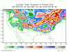
12z GGEM jet structure...notice the "rear right" and "front left" exit regions are right over KC/N MO/N IL/N IN/S MI area....maximizes lift potential.1 point
-
Keep in mind, the lake temp's back in 2013 were a lot warmer to begin the season than this year. I believe this year, all of the lakes were below normal temps wise and this gave the lakes a head start along with the colder November. I saw Skilling's midday show yesterday and he posted a graphic indicating that last February was running even colder than this year's.1 point
-
Wow, huge step in the right direction on the 12z GGEM...this is turning towards a powerhouse Pan Handle Hook....1 point
-
Here is the 0z GEFS Mean. I'm guessing the 6z was not that great but haven't looked yet.
 1 point
 -
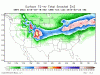
12z Euro ensembles from yesterday match up nicely with the 0z runs overnight. Ukie has had this storm from day one and really has not waffled too much as far as track goes. If the track continues then got to give kudos to the Ukie for sniffing this out again!1 point
-
A little better phasing and this will go back to what the 00z GFS looked like...1 point
-
Winter never started. We went straight from Fall into Spring. BTW I'd be happy with the scenario you painted earlier.Heavy mtn. snow for the next two months, followed by glorious summer weather. I went climbing yesterday near Leavenworth and there was barely any snow below 5K. Conditions are what you would expect in mid to late June right now.1 point
-
That's only 600 feet below you! Gotta be nerve wracking...1 point
-
From LOT:1 point
-
00z Euro also starting to bring some nasty cold next Tue-Thu....a brief pull back late month, but Ensembles indicating the cold to begin to build in western Canada and bleed south, east of the Rockies. This type of pattern would be excellent to brew up some more nice Cutters down the road.1 point
-
Mark Nelsen just officially declared winter dead below 1000'.1 point
-
Ok, what is it?1 point
-
Honey, that got exposed a long, long time ago. Right now it's just about killing time until the ice age.1 point
-
Sure, the reason it's happening is nothing remarkable, but 35+ degree spreads are not super common in the PNW lowlands. I remarked that OLM put up a 62/26, which doesn't happen every February. Never suggested we should make a separate thread to commemorate it. I've reminded people that no pattern lasts forever, if you want to call that "preaching pragmatism". Not sure what you're referring to.1 point
-
So why come post here at all, if all you're posting is how nothing could possibly excite you at this point?1 point
-
I don't think anyone on here likes getting missed by winter storms. We are hitting our stride as we speak and Winter is about to deliver some very interesting storm systems over the next 2-3 weeks. Let's all try to enjoy tracking winter storms as much as we can before Spring arrives.1 point
-
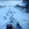
Couple pics from the neighborhood this morning.1 point
-
When I lived in the PNW, June was probably the last month I wanted historic troughing.1 point
-
I'll take 80 degrees right now if it nets us some historic June troughing!1 point


This leaderboard is set to Vancouver/GMT-07:00