-
Who's Online 15 Members, 1 Anonymous, 58 Guests (See full list)
-
Activity Stream
-
2047
June 2024 Pacific Northwest Weather
I did it last September! Walked right up to the summit in trail runners, didn't even touch snow. I'm guessing it was more of an adventure this time of year! -
2047
June 2024 Pacific Northwest Weather
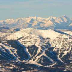
Expect widespread wet conditions with very cool conditions, winds will turn northeasterly. Heavy, wet accumulating snow is expected above 5000 feet, throughout southern Idaho County and most of western Montana. In western Montana, above 6000 feet a trace to 14 inches is possible, while in the Bitterroot, Anaconda, and Pintler Mountains, Bob Marshal Wilderness, and Glacier National Park Region the highest terrain has a 25% chance of receiving 14 to 20 inches of snow. This amount snow accumulating on trees with foliage could cause branches to go down on back country roads, be prepared. Due to the high impact potential above 6000 feet and moderate confidence of the event actually happening, winter storm watches have been issued along Continental Divide from the Canadian border through MacDonald Pass on I-90, including Georgetown Lake and the Anaconda and Pintler Mountains. The main snow event will be overnight Monday through Tuesday. Similar events to this one, in June 2008 and 2001, produced a small area of valley snow down to 2800 feet. There is insufficient confidence in either low pressure track or intensity currently, but you are encouraged to follow future forecasts as 1 to 2 inches of heavy, wet snow on trees with leaves could easily cause broken branches leading to localized power outages with winter driving conditions in area mountain passes. MSO referenced June 2001. Bozeman got 18” from that storm. I moved there a few years afterward but heard stories. -
2047
June 2024 Pacific Northwest Weather
Photo 1 and 2 look amazing, it's got me looking forward to going up to the north cascades in a few weeks! -
8783
Polite Politics
My wife worked on a dementia unit for 5 years. She said he 100% has dementia. -
8783
Polite Politics
smh. Honestly, his look/behavior (not always, but too often) is one of somebody with dementia or a closely related condition. I'm sure most of us have seen stuff like this in our own families.
-