
All Activity
- Past hour
-

West Coast Sports Talk and Other Banter
SilverFallsAndrew replied to Anti Marine Layer's topic in West of the Rockies
More basketball news.
-
April 2024 Weather in the PNW
SilverFallsAndrew replied to Tyler Mode's topic in West of the Rockies
Last year we had our biggest august rain since 2015. -
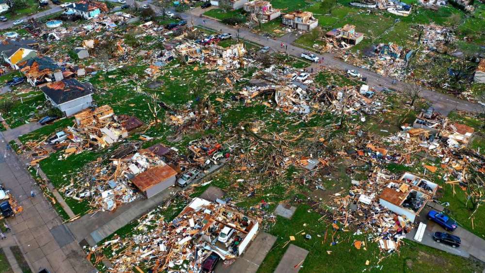
 Ended up being too far north for the severe weather, mainly just had a couple rumbles of thunder. We did receive some beneficial rainfall though with 1.12 in the bucket. We are now above average for total April precip. If I knew the tornado outbreak was going to be as prolific as it was down near Omaha yesterday I would have tried to make my way down there and check it out. Ever since I watched Twister as a kid, I've always wanted to see a tornado in person. Maybe one day.
 - Today
-
Yesterday I woke up to a temp in the 40s with a dewpoint in the low 30s. Today it is in the 60s with a dewpoint in the low 60s.
-
It's a very nice and cool 57F here today with partly cloud skies. It has been quite breezy the past few days and today will be another repeat performance. I'm certainly enjoying the BN temps after reaching the 100's earlier in the week. Low 80's are kinda cool to the skin when you leave the pool, esp in the wind and dryness of the air.
-
 Up to 100 preliminary #tornado reports for the tornado outbreak yesterday in Nebraska, Iowa, Kansas, Missouri and Texas with another high-end tornado outbreak possible today over the southern Plains
 -
 That sounds wonderful and I think you will have full ponds after this event...you've missed out on the previous storm chance but now it appears the tables have turned. Not just you, but a lot of peeps on here have scored. @Grizzcoat, you really did a good job capturing those TOR's and I'm sure this will be a vivid memory that will be remembered for the rest of your life. I'd love to go storm chasing one day and be able to hear the sights and sounds of a EF 3 or higher. Just and incredible thing to be able to witness. Those wedge TOR's were just picturesque Beasts across NE into IA!
 -
 Tonight is still uncertain for us. Models are predicting anything from a half inch to three inches of rain. I'm afraid the ones showing storms popping near to just south of us and then propagating southeastward will be correct. That would dump inches of rain over southeast Iowa down into Missouri, but much less here.
 -
My ponds are running about half full atm, the streams have running water for the first time this spring. 5 additional inches of rain will just about fill them up.
-
You love to taunt. It’s pretty much all you have here. But you might watch your online back. What goes around comes around. There’s always a bigger bear. It’s people like you that make me want to walk away from all this. You love to piss in the punch bowl but come back for a second glass. I’ve dealt with some real online masters at this and find they stand on feet of clay.
-
Looks like may will kick-off wet for mby. Models indicating 1-2 inches of rain possible, this wet pattern sure is welcome.
-
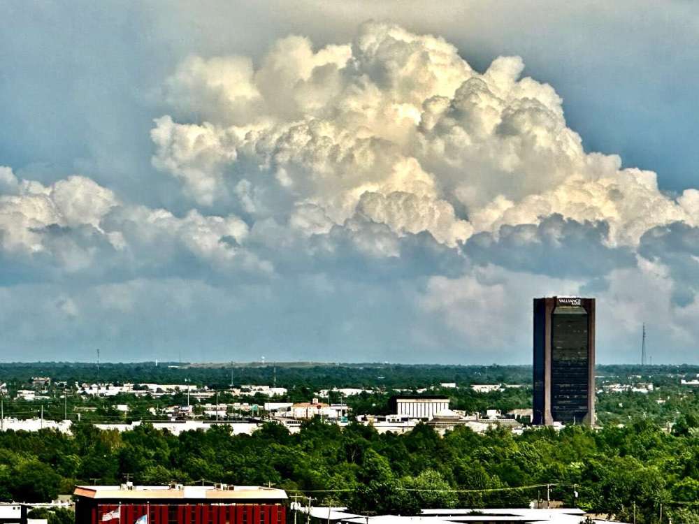
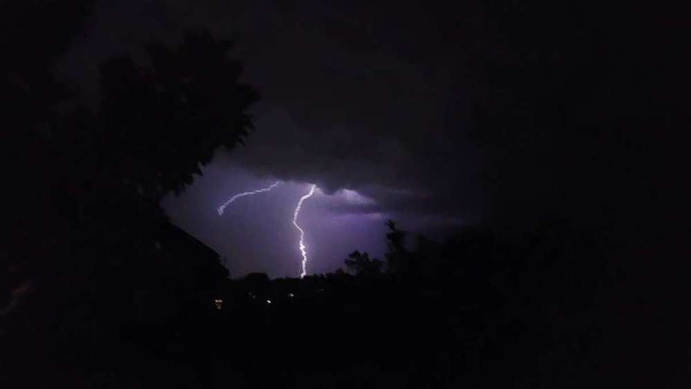
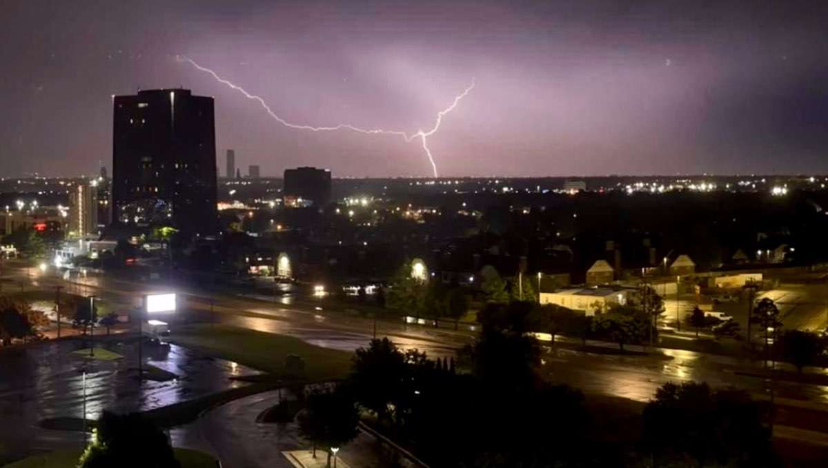
 We’re in Oklahoma City today not sure if I’m going mobile or watching the action from our hotel. Anyhow looking forward to a fun day. Had a nice show from our room two nights ago.
-
You have definitely been near ground zero in the heavy rain dept....fill up those bonds and creeks! I think @OKwx2k4 did pretty good yesterday from that strong line that went through in the morning.
-
I have an enhanced risk for severe weather and a Flood Watch currently in effect. I believe strong winds, hail and flooding will be my biggest threat. The GFS and HRRR which have both nailed the high rainfall totals in my area are showing 4-6 inches of rain for mby.
-
 Absolutely insane seeing all the damage in Nebraska and Iowa.
-
 But I see SPC has a Moderate for today's outbreak. As well as an overall meatier looking Enhanced.
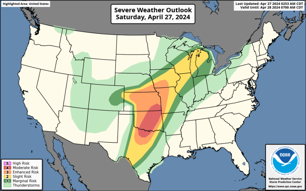
-
Haven't had a bunch of time to track these most recent storms. I heard part of Omaha had a wedge tornado? I can remember a few saying there should be a moderate risk but the SPC never put one up.
-
Don't forget Breitbart.
-
 Right one went wedge and hit Minburn. Saw at least 7 tornadoes and saw 2 tornadoes together twice. PXL_20240426_222456152.mp4
 -
The official H/L yesterday at Grand Rapids was 64/34 there was 0.01” of rainfall and the sun was out 52% of the time. The average wind speed was 13.1MPH and the highest wind was 33 MPH out of the SE. For today the average H/L is 63/42 the record high of 85 was set in 1990 and the record low of 27 was set in 1928. The most rainfall of 1.90” was in 1956 the record snowfall was 0.2” in 2004. Last year the H/L was 64/29. Here in MBY I had 0.09” of rain since 7AM yesterday and the overnight low of 53 was around midnight. At the current time it is cloudy and 58 here.
-
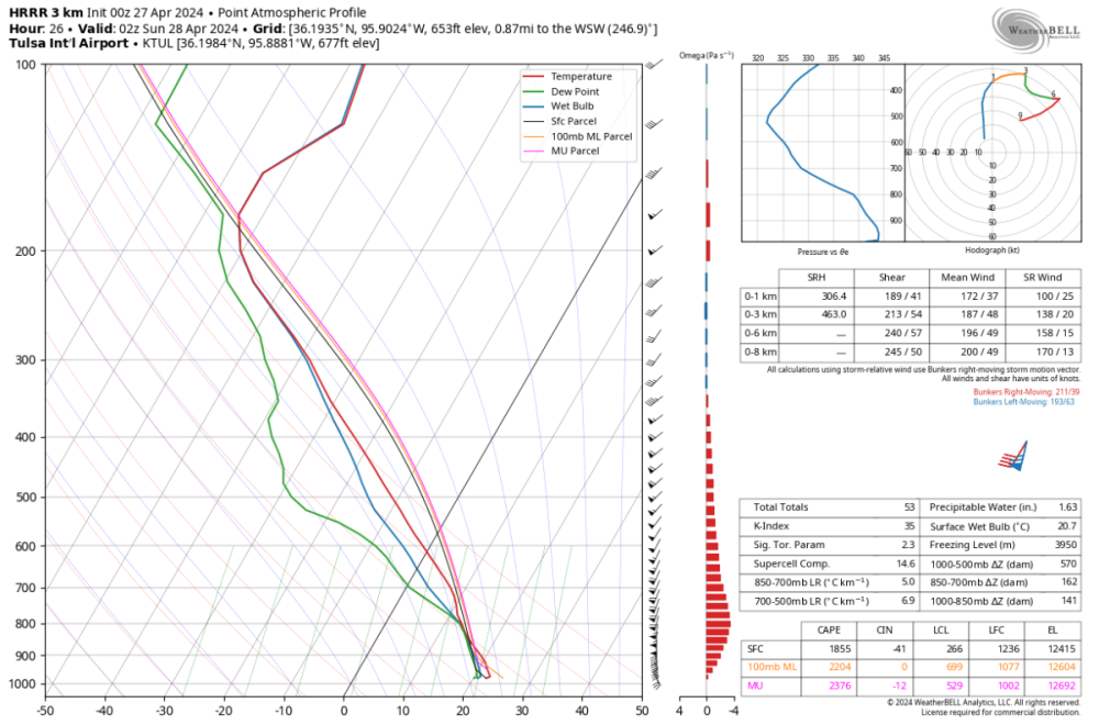
 For the early afternoon SRH is limited but CAPE is huge. The CAPE is probably overstated given entrainment, but this does certainly support large hail Later in the day the hodograph blows out as the LLJ kicks in. This looks more like a QLCS tornado threat as a presumably linear feature moves in.
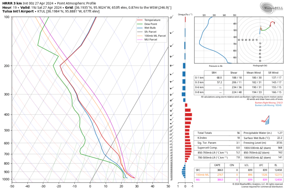
-
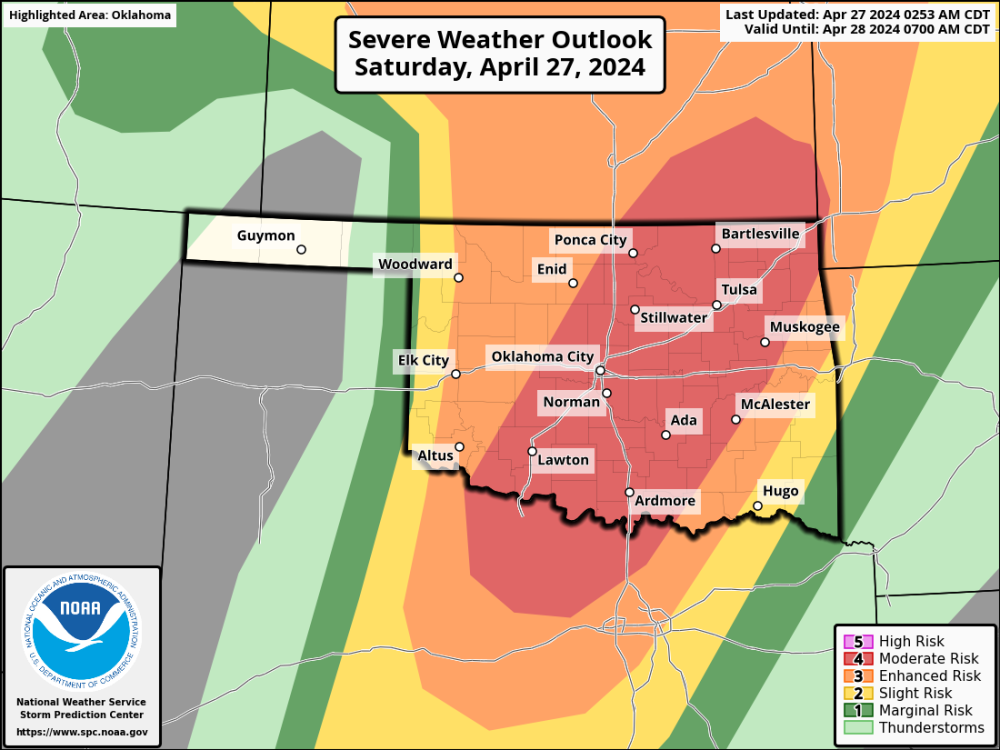
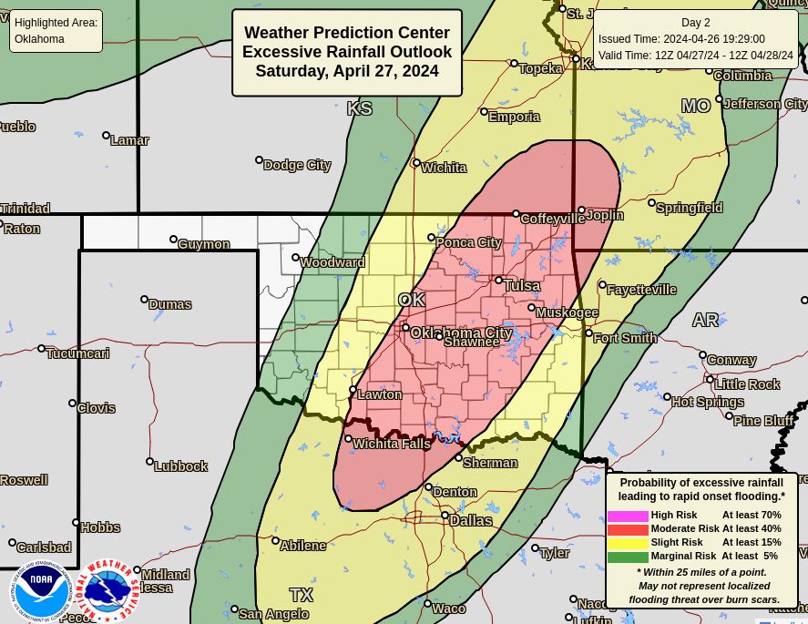
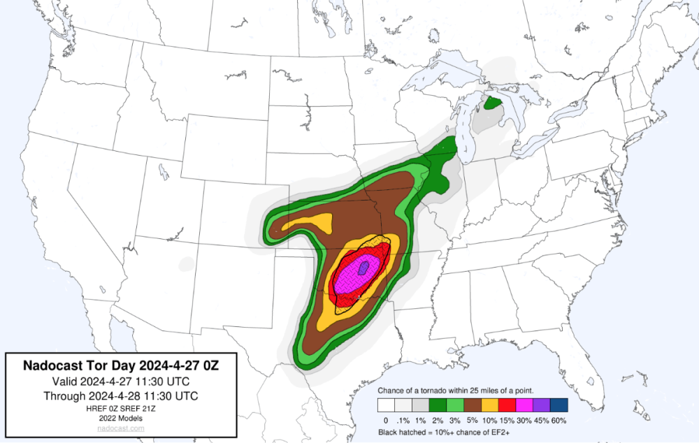
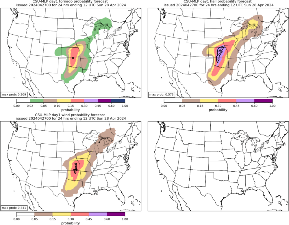
We've got a moderate for severe from SPC and for rain from WPC: Some ML guidance shows the highest threat more towards my area like nadocast: But others like CSU is a bit further west: I'm inclined to think the biggest severe weather threat will be further west towards OKC. I expect to see several strong tornadoes and reports of very large hail. As the storms congeal we will get a wind/QLCS threat morphing into a heavy rain/flood threat overnight. I don't think we will get anything truly crazy, but a couple of inches wouldn't shock me.
-
Are you talking about the 8 weeks of July and August? Because it almost always rains in June and September with only a few exceptions. SEA averages .60 in July and .97 in August. So in order to have a rainfall every 2 weeks it would need just 2 events each month. July and August in recent years has been an anomaly.
-
Last summer had some really nice thunderstorms in May and August/September here
.thumb.jpg.59b53db63bc12c417a80bab8c346b523.jpg)
-
Like scared there might be a marine layer that doesn’t burn off until 11 or so some days scared?


.jpg.36ade29958b6bf634cf1dca2f7170ca0.jpg)
