
Leaderboard


Popular Content
Showing content with the highest reputation on 03/02/17 in all areas
-
Those numbers are surely good enough for lowland snow. The 522 thickness line is way south of us and surface gradients are weak offshore. I need this to get my winter total over 10 inches so the stakes are high!4 points
-
Never too much snow. Every time is like the first time... that never changes.4 points
-
I can see how some would understand why tim could get tired of it, but there is a reason you choose to live at 1100 feet elevation in the cascade foothills. I don't think you should be allowed to post in this section of the weather forum if you get tired of snow. This should actually be call "thesnowloversforum.com3 points
-
Since some people get too attached to SSTs (looking at you Tim), thought I'd share this http://i.imgur.com/bBGJ4ak.jpg2 points
-
No need for that in here. Our members respect one another.2 points
-
Did someone spill your starbucks today?1 point
-
I'm down for more winter. Let's do this!1 point
-
0z is good. Low pressure west/south of us for several days. I had 3.5-4" fall midday this past week, and this upcoming weekend looks just as good or better in terms of putting the L in the sweet spot. I can realistically see 3-6" totals pretty widespread for Whatcom County. The difference maker could be the time of day the heaviest showers fall too. Hoping for the best! .... Almost expecting it at this point. Based off of the lack of activity on the forum I actually believe that most people are ready for spring.1 point
-
More severe wx next Monday for the same areas who just experienced some this week???1 point
-
So Sunday morning has trended a little less marginal than it was looking like it would go. It's evolved into more of an outflow pattern with 925mbs going down to about -3~4C and 850mb around -7C, very similar to what we saw this past Monday. However, the low looks a bit stronger and there won't be as much low level drying ahead of it; lots of uncertainty around where the precipitation will end up as usual. Sure would be nice to get a weekend snowfall for a change. http://www.tropicaltidbits.com/analysis/models/gfs/2017030300/gfs_mslp_pcpn_frzn_nwus_10.png1 point
-
Before that they were only awake in 2009, 2006 and 2002.1 point
-
Portland NWS said this was a typical pattern for this time of year in their AFD1 point
-
I tend to forget torch winter months. If March torches I will remember that, lol since 2012 is emblazoned on my brain!1 point
-
not if the 18z is wrong1 point
-
Your kids will be put in it when it snows. Snow lovers can say they arent excited for more snow, but it all comes out when the flakes begin to fall... maybe just my opinion.1 point
-
The atmosphere is in its most Niña like state yet, FWIW. Check out the ENSO thread.1 point
-
I've definitely had my snow appetite sated by this winter. It would be cool if it snowed again, but I'd rather it snow a lot or not at all, I'm not excited by one or two inches at this point.1 point
-
The winter temperature anomaly was subtle in SoCal due to clouds. Winter mean [58.4°] was below normal [60.1°] at my location but this is only 23 years of data. Generally, the warmer nights negated the cool cloudy days for near normal means. Heating degree days are fairly high [608 since 7/1/16].1 point
-
I couldn't really tell if you were digging at me haha.1 point
-
Why don't you post from your old user name?1 point
-
You got that right1 point
-
Keep that boat winterized a little longer, looks like we are not quite done yet. I sure hope this summer ends up okay... i'm still fearing a dud however. Jesse's mind powers are trying hard to give us a cold and wet summer I have a feeling!1 point
-
1 point
-
Ensembles appear to be trending colder.1 point
-
A cool and wet couple weeks in the offing...snow levels around 1500-2000' through early next week rising a bit mid week and falling back down toward 2000-3000' through mid-month. QPF looks robust...130-150% of normal for PDX. Good spring snow pattern, resorts should see increasing base depth.1 point
-
I will take that! Bryant and our other northern friends i'm sure will take that map as well.1 point
-
DJF coldest on record (airport 1940-2017), mean temp: 35.0 1948-49 35.7 1949-50 36.3 1978-79 36.3 1968-69 37.2 2016-17 Pre-PDX: 36.3 1889-90 36.5 1892-93 36.6 1928-29 37.5 1909-101 point
-
GFS showing snow for the East side Sunday into Monday now.1 point
-
Looks good for northern areas. Hope I-90 can join the fun.1 point
-
60s back in the point for Sunday and Monday. MPX says 70s possible in SW MN. 25F and bright blue skies right now though.1 point
-
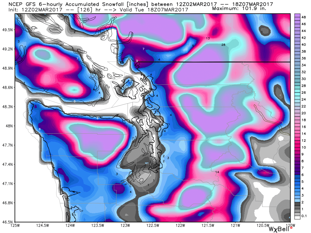
GFS showing lowland snow as early as Saturday morning early. Skagit Valley cashes in.1 point
-
Wow, seriously. Maybe you should actually look at the models like Timmy did before you mouth off like an idiot. I have no idea why you have to make comments like that.1 point
-
Gfs shows 6" over pdx in the next 100 hours1 point
-
Ah. I wasn't looking that far out. Still doesn't look too exciting to me. I think March should be the end of GFS alerts.1 point
-
I don't know if everyone has picked up on it yet...but Andrew lies here for fun.1 point
-
More 70 degree weather in Philly! I'd take that over 40 degree rain.1 point
-
Yup! I saw some decent snow fall rates yesterday as I was clipped by the defo band from the last system but it didn't last to long. It was very windy and at times the rates were surprisingly good. This morning I'm seeing more snow shower activity.1 point
-
What a difference 12 hours and one run makes..... http://www.tropicaltidbits.com/analysis/models/ecmwf/2017030200/ecmwf_T850_us_11.png1 point
-
That doesn't seem ironic to me. I like some EDM too.1 point
-
Accumulating March snow is extremely common in the PNW. Just not in the lowlands below 1000'.1 point
-
Where is our friend Heavy Snow to weigh in when we need him.1 point
-
Atleast they got a good December. I believe they are right at or slightly above our season total even with the last 2 months. That's so depressing.1 point
-
Certainly not in this sub forum, but I noticed that there are Blizzard Warnings for the higher terrain on the big island of Hawaii. You don't see that everyday, but add it to the list of things you've seen this winter that you typically don't see.1 point
-
I have issued you a warning for that garbage. Don't show up and act like a tough guy or you will be gone from this forum faster than you can swallow..1 point
-
0z EURO with a massive blowtorch in the central CONUS. Temps in the 90s possible for the Nebraska peeps?1 point


This leaderboard is set to Vancouver/GMT-07:00