-
Who's Online 28 Members, 3 Anonymous, 133 Guests (See full list)
-
Activity Stream
-
149
March 2026 Observations & Discussion
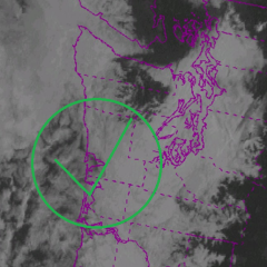
I’m following it on Michigan storm chasers. Had a live view of it. Looked like a decent wedge tornado just formed again. Lots of damage so far. Unfortunately it’s not in a radar range of any site for good velocity data. -
471
March 2026 Weather in the PNW
Today's gloomfest is bought to you by ridging overhead... the absolute worst position for ridging for western WA. Just pumps in the muck at all levels. The cold troughing next week will be much brighter at times.- 1
-

-
471
-
149
March 2026 Observations & Discussion
Looks like early March 2000 had similar warmth around here. Don't really remember it for some reason. I remember the early April 2000 snow more. That's basically it though in my lifetime as far as temps this warm this early. -
471
March 2026 Weather in the PNW
That is pretty good AI. Sun angle is actually consistent with where it would be at this time of day. Although some of the shadows are not at consistent angles.
-