
Leaderboard


Popular Content
Showing content with the highest reputation on 01/29/15 in all areas
-
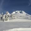
Some pictures from the cape during and after the storm. Our spit: Community service truck that got stuck in the snow. During the blizzard from the top of the beach...visibility is about 50-100ft. Hopefully these posts aren't too off topic but considering how dead it is in here...3 points
-
This accurately describes what Chicago does to Nebraska every storm http://www.gifbin.com/bin/062013/1370886029_kill_steals_baseball_from_girl.gif2 points
-
Hi REs NAM also following the trend--- NOTE only through hr 60-
 2 points
 -
LOT's take on the extended forecast FOLLOWING THIS SYSTEM...IT APPEARS THE REGION WILL REMAIN IN AND ACTIVE WEST/NORTHWESTERLY FLOW PATTERN. THIS COULD SUPPORT A FEW ADDITIONAL CLIPPER TYPE SYSTEMS WITH SNOW CHANCES AND REINFORCING SHOTS OF COLD AIR THROUGH THE EXTENDED PERIOD. OVERALL...IT APPEARS THAT WE WILL REMAIN BELOW TO WELL BELOW AVERAGE FOR TEMPERATURES NEXT WEEK. A PERIOD OF VERY COLD CONDITIONS COULD ALSO BE IN THE WORKS FOR THE LATTER PART OF NEXT WEEK...WITH THE POSSIBILITIES OF A SYSTEM DIGGING SOUTHWARD OVER THE AREA FROM THE HIGH LATITUDES OF CANADA.2 points
-
There is a report button for a reason people. If you have a problem, use it.2 points
-
lol. you're such a troll2 points
-
The one piece of good news is the CFS now shows a good chance we will avoid a Nino next winter. 7 of the most recent 8 ensemble members shows Nino 3.4 below +0.5 by Oct 1. A huge change from what It had been showing.1 point
-
LOL, are you really comparing us to Juneau? Their winter clearly extends to late March. Every year.1 point
-
Looking back at this thread and people calling storm cancel because of the 84 hr nam was pretty funny.1 point
-
Well, the Juneau people were saying winter was over less than a week ago, and they just saw a 6" snowstorm. There are some subtle changes in the pattern now that open the door for more interesting and potentially active weather in the near future. Right now things don't look great, but the 0z models took a step in the right direction. All it would take is a little bit stronger and better placed high here, and a further south low pressure system there, and things could get interesting. All I'm saying is, don't get too caught up in how boring this month has been and assume nothing will change.1 point
-
http://i.imgur.com/FfEJfF3.png1 point
-
Mountain snow is what we need. I'm over waiting for it in the lowlands.1 point
-
A little love for SE NE-
 1 point
 -
You have GOT to be kidding me. I guess I shouldn't be surprised.1 point
-
Bufkit sites--- helps determine whats what--http://www.meteor.iastate.edu/~ckarsten/bufkit/data/1 point
-
What a giant middle finger to us. LOL1 point
-
Given the winter so far, this might as well be GHD 2.0 lol, it might feel like it. Really hope this one is a bit easier to predict and doesn't shift a ton in the last couple days, maybe slight adjustments northward. Have to say, the more I look at it, the more I realize that those saying this might be a candidate for a N/NW shift could be right.1 point
-
I'm still trying to hold my excitement, but this looks to be a fantastic set up for most of the sub-forum. Let's hope models have the evolution of this system handled.1 point
-
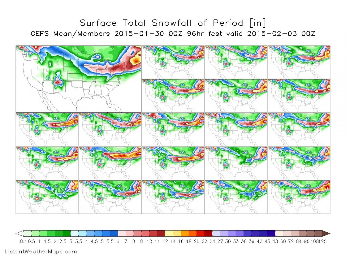
00z GFS also has a sweet LES signature all the way from GRB down to ORD...total run...notice those totals lakeside. If the models are picking this up 48 hours out, imagine what they will be the day of the event. Could easily add 2-4" on top of system snows.1 point
-
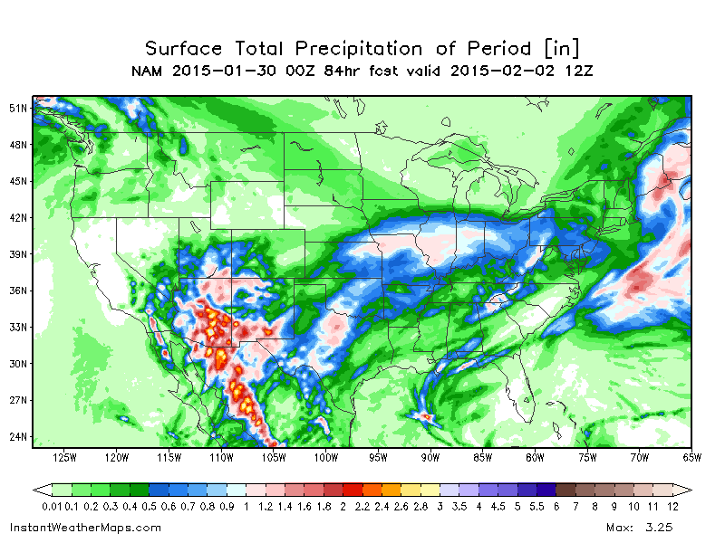
Big northward jump with the precip compared to 18z. Precip is already reaching northern iowa at hr 45 while 18z didn't even have it in southern iowa1 point
-
21Z SREF shows similar trend to 00Z nam1 point
-
00z NAM full run...12" lolipops showing up near C IN/OH...1 point
-
Yes--- it's like partly trying to phase-- or at least earlier-- so close.1 point
-
The LES is setting up to be something of a beauty with about 24 hours of sustained winds off the lake. Somebody is going to cash in big on lake enhancement. I think what we will likely see is banding to start forming near MKE initially around 9pm Saturday as the cold front slides down south. Temps during the onset begin near 30F, then fall into low 20's for the duration of the event.1 point
-
MKE gets into the 3"+ mark...1 point
-
for sure--- a little more and she will really take off..1 point
-
I think there is much better phasing of northern/southern stream....1 point
-
I'm enjoying lemonade.1 point
-
The last 3 winters in a row have been brutal up here in Victoria for snowfall. 2012/13 - no snow and no high temps below freezing 2013/14 - 1-2 inches of snowfall and about 5 high temps below freezing (higher elevations got more) 2014/15 - a trace in November and 1 high temp below freezing Basically 2 out 3 winters with no snowfall. I have been living here since 1989 and this is the worst 3 year stretch. Even 1999 - 2002 wasn't as bad as this.1 point
-
Went on a great bike ride in the sun today to the Ballard Locks. 3 feet of snow would be nice, but I'm enjoying some lemons for now.1 point
-
Yup. I am right there with ya. If we didn't have all that rain in the late fall, we would be in a serious situation right now.1 point
-
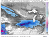
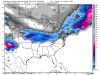
Nice write-up by LOT: SATURDAY NIGHT THROUGH THURSDAY... THE MAIN FOCUS DURING THIS PERIOD WILL BE WITH THE INCREASING POTENTIAL OF A DECENT ACCUMULATING SNOWFALL EVENT ACROSS AT LEAST PORTIONS OF MY AREA SATURDAY EVENING THROUGH SUNDAY. A COMPLEX WEATHER PATTERN WILL BE IN PLACE ACROSS THE CONUS DURING THIS PERIOD. OVERALL...THE MAIN DISTURBANCE OF INTEREST IS NOW EJECTING EAST-NORTHEASTWARD ACROSS THE NORTHEASTERN PACIFIC ALONG THE EASTERN PERIPHERY OF AN UPPER LOW SOUTH OF THE ALEUTIANS. THIS FEATURE WILL MOVING ONSHORE ACROSS THE BRITISH COLUMBIA COAST BY FRIDAY MORNING...THEN IS EXPECTED TO DIG SOUTHEASTWARD ALONG THE NORTHEASTERN PERIPHERY OF AN UPPER LEVEL RIDGE IN PLACE ACROSS THE WESTERN CONUS. THE MAIN COMPLEXITIES WITH THIS SYSTEM...IS IF AND HOW MUCH OF THE SOUTHERN STREAM ENERGY...EMANATING FROM THE SOUTHWESTERN CONUS TROUGH...GETS TAPPED INTO BY THIS DIGGING SYSTEM. MODEL GUIDANCE HAS FLIPPED FLOPPED A BIT OVER THE PAST COUPLE OF RUNS ON HOW FAR NORTH THE ACCOMPANYING PRECIPITATION SHIELD WILL GET SATURDAY NIGHT INTO SUNDAY. IT APPEARS ONE OF THE MAIN KEYS THAT WILL PLAY A ROLE IN HOW FAR NORTH THE SNOWFALL ENDS UP GETTING ACROSS ILLINOIS WILL BE THE TIMING OF COLDER AIRMASS/COLD FRONTAL PASSAGE EXPECTED ON SATURDAY NIGHT. A MUCH COLDER AIRMASS IS EXPECTED TO SPILL IN ACROSS THE NORTHERN CONUS AHEAD OF A STOUT 1044 MB HIGH BUILDING SOUTHWARD OUT OF SOUTHERN MANITOBA SATURDAY NIGHT...AND THIS SHOULD SET UP A GOOD BAROCLINIC ZONE POTENTIALLY RIGHT ACROSS THE HEART OF MY CWA SATURDAY NIGHT INTO SUNDAY. AT THE SAME TIME...ISENTROPIC ASCENT AND MOISTURE TRANSPORT WILL RAMP UP TO OUR SOUTHWEST IN ADVANCE OF THE APPROACHING DISTURBANCE. THIS SHOULD RESULT IN A LARGE AREA OF SNOWFALL DEVELOPMENT IN THE COLD AIR ACROSS MISSOURI AND WEST CENTRAL ILLINOIS BY SATURDAY AFTERNOON. IT APPEARS THIS SNOWFALL WILL GRADUALLY DEVELOP NORTHWARD ACROSS ILLINOIS BY SATURDAY EVENING...AND MAY END UP IMPACTING MOST OF MY AREA TO SOME DEGREE OVERNIGHT SATURDAY AND INTO SUNDAY. IT APPEARS THAT A DECENT BAND OF FRONTOGENESIS COULD SET UP SOMEWHERE NEAR THE I-80 CORRIDOR INTO SUNDAY MORNING AS A DEFORMATION AXIS TRIES TO DEVELOP WITH THE 925-850 MB LAYER AHEAD OF THE APPROACHING COLD AIRMASS. THIS COULD RESULT IN SOME AREAS OF HEAVIER SNOW. HOWEVER...CONFIDENCE ON WHERE EXACTLY THIS ENHANCED MESOSCALE FORCING SETS UP IS LOW AT THIS TIME...GIVEN THIS SYSTEM IS 60+ HOURS AWAY. IT DOES APPEAR THAT MOST AREAS MAY SEE AT LEAST SOME LIGHT SNOW ACCUMULATIONS...BUT THE POTENTIAL OF A FEW TO SEVERAL INCHES OF SNOW ACCUMULATION IS CERTAINLY A POSSIBILITY. THE OTHER FACTOR TO CONSIDER WITH THIS EVENT IS THE POTENTIAL FOR LAKE ENHANCED SNOW SHOWERS LATER SUNDAY AND INTO SUNDAY NIGHT ACROSS NORTHEASTERN ILLINOIS. AS THE COLDER AIRMASS BEGINS TO SPILL SOUTHWARD OVER THE AREA ON SUNDAY...WINDS WILL BECOME NORTHEASTERLY OFF OF LAKE MICHIGAN. THE COLDER AIRMASS...FEATURING 850 MB TEMPERATURES IN THE TEENS BELOW ZERO CELSIUS...SHOULD ALSO PRODUCE FAVORABLE THERMODYNAMICS IN THE LOWEST LEVELS OF THE ATMOSPHERE FOR ENHANCED SNOW SHOWERS LATER SUNDAY AND SUNDAY NIGHT. MODEL SOUNDINGS INDICATE INVERSION HEIGHTS REACHING UP AROUND 5-6,000 FEET...WHICH SHOULD EXTEND WELL INTO THE DENDRITIC GROWTH ZONE. THEREFORE...WE CANT RULE OUT THE POTENTIAL FOR SOME HEAVIER SNOW TOTALS ACROSS PORTIONS OF NORTHEASTERN ILLINOIS. AT THIS TIME...I HAVE REMAINED A BIT CONSERVATIVE ON SNOW AMOUNTS ACROSS NORTHERN ILLINOIS...MAINLY DUE TO THE HIGH UNCERTAINTIES WITH THIS EVOLVING SYSTEM.1 point
-
They seem to be with the 18z GFS showing between 0.2 - 0.3qpf...temps are in the low 20's to fluff up those totals.1 point
-
A whopping .2" of precipitation around here.1 point
-
SREF mean up to 5" for ORD and rising each run! Good sign i think1 point
-
http://www.tropicaltidbits.com/analysis/models/jma/2015012912/jma_apcpn_us_5.png 1+ for you Chicago posters.1 point
-
I believe the models are finally picking up on the nice moisture feed (again) from the Gulf/Atlantic just like they were showing a few days back. Really liking that ensemble map bud!!1 point
-
Might as well 12z JMA http://www.tropicaltidbits.com/analysis/models/jma/2015012912/jma_z500_mslp_us_5.png1 point
-
Skilling's RPM model showing the northern stream and southern stream interacting a little better. It looks similar to what the Euro is showing.1 point
-
Are GDR and BigDizBliz420 the same poster?1 point
-
Notice the better phasing this run....its slight, but BIG difference....comparing 00z/12z1 point
-
Relevant information for LES potential. http://www.crh.noaa.gov/news/display_cmsstory.php?wfo=grb&storyid=106433&source=01 point
-
Euro will be north, I think.1 point
-
UKIE is ranked the 2nd best model behind the EURO1 point
-
I am seeing an up and down pattern. Agree to disagree.1 point
-
The 6z GFS has shows only about 6 hours or so out of 384 hours where we aren't under a positive 500mb height anomaly; a continuing theme this winter. The ensembles show much of the same taking us out to Feb 14.1 point
-
Yep, LES will be key to how much snow we get into these parts although we really are not that far away from seeing some decent accumulations.1 point


This leaderboard is set to Vancouver/GMT-07:00