
Leaderboard
.thumb.jpeg.e3014abf99ef08a9f9ac2c0cd31b485b.jpeg)


Popular Content
Showing content with the highest reputation on 12/18/16 in all areas
-
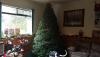
Been a emotional day.. First time in 27 years i went and picked a Christmas tree without my woman but me and my son made the best of it and had a good time. Its been a real test as a father dealing with all this. Dont want to sound like a wimp but life is so short. All who have a wife or significant other go give them a hug and spend every second with them like its the last!! .
 20 points
 -
Jesus Christ, Tim. Give it a rest.5 points
-
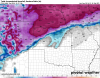
Chilly winter so far. Looks to stay chilly.4 points
-
After seeing the 00z GFS, I think I speak for a few on this board when I say the following... There have been 2 default storm tracks so far, one that brings snow to PDX/SW Wa, and one that brings snow to northern whatcom county/southern BC. Lets average that out and fill between the lines with the next system or 2. They've had enough for now3 points
-
Snowing at a decent clip here now. 25*F. THIS IS AWESOME. I don't care what happened yesterday or tomorrow or in 20 minutes. When it is snowing, the world completely stops. There is nothing like it!3 points
-
What is it with these Oregon-only snow events...? This is really becoming a little irksome.2 points
-
0z GFS is takes a step towards the Euro in the mid range. Shows a little lowland snow on Saturday and is pretty close to a significant snowstorm.2 points
-
Some people hate cities. I hate that I have to go to Salem everyday. I don't like going into Silverton on weekends if I can help it2 points
-
Yes. Go Bucs!2 points
-
Should I stopp reporting my snow? I didn't complain when others saw snow last week..2 points
-
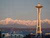
Agreed. It is very magical driving west on 90 seeing Puget Sound and the Olympic mountains glistening white. Reminds me of Scandinavia. Very unique.
 2 points
 -
I'm so happy for you. Couldn't happen to a nicer guy.2 points
-
Yeah, I was totally bummed with the automation (1996, I think?) because it shuttered the Astoria forecast office. I'll never forget getting to tour it a couple times and work with one of the mets on a school project. I even got to record one of the hourly roundups. You would have thought I was being allowed to fly the spaceshuttle or something. So much of my youth was based on those guys' voices. They tought me how to read a weather chart, modeling and soundings.2 points
-
Sounds like the one is definitely down with the sickness.2 points
-
Best wishes during this season. It's been almost 10 years since my mom passed. I have never really talked to my father about it, which may sound weird but that is kind of how our family is. But I think he is at peace knowing he gave those 25 years all he had and focusing on all those good memories.2 points
-
I'm sitting here in near disbelief the torchy nightmare of the past few years is over. So nice to see the cold!2 points
-
12Z GFS gives metro Vancouver an 8" snowstorm throughout the day on Christmas2 points
-
This has been a December to remember so far!
 2 points
 -
Up to 17.7" at ORD officially for the season and we are half way through the month. It looks beautiful outside with the freshly fallen snow and some minor snow drifts. Morning sunrises this time of year with a glittering snow cover and a hot cup of coffee are the simple things in life that bring a smile to my face! Do we set a new record at Soldier Field today??? 2.5 hours till kick off time...gonna be close but the old record is 2F at kick off.2 points
-
just over a half inch here so far and still light snow.2 points
-
I'd say we got 8" - 8.5" here or so. The second wave was a nice addition to the disappointing first wave. Happy to see the snow mounds growing nice and high, especially after last year!2 points
-
Amazingly tonight's Euro shows way more snow for King County late tonight than any previous run. 1 to 3 inches in a lot of places. I'll have to see it to believe it.1 point
-
1 point
-
Looking a little more favorable tonight for widespread frozen precip around here. Dew points in 25-27 range and light east wind still going at PDX. Question is if we have any window at all for much accumulation.1 point
-
I don't know. But he's picking apart the Cowboys defense now.1 point
-
17-6...bam! Haha1 point
-
That'll make you feel alive. Surely won't need coffee to wake you up.1 point
-
1 point
-
You have no room to complain with the totals you have seen so far1 point
-
Eh, depends on what you're comparing to. Seattle does get more sunshine and dry weather than most Puget Sound locations thanks to being directly in the Olympic shadow. And they tend to do well with Arctic fronts, at least better than most places further south. See: Nov 2010, Nov 2006, Dec 1990, Feb 1989, Mar 1989, etc.1 point
-
Well, there's no gorge outflow. Whatever cold is around is already here. I'm sure most people will start as sleet or maybe very brief snow.1 point
-
Seattle has gotten so absurdly liberal I wouldn't live there in a million years. They police your garbage for crying out loud. That and the fact the city proper has a totally loser climate.1 point
-
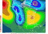
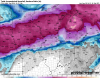
Euro ensemble mean at day 10.
 1 point
 -
Would be enough to keep me away from the inlaws. miracles like that dont even happen on christmas1 point
-
Best wishes to you this Christmas season. Nothing wimpy sounding about that at all, it really is important to make the most of the time you have with those you care about because it won't last forever.1 point
-
Wonder how this one is going to miss us?! I'm guessing won't be as strong of a storm as being shown.....this would be a Christmas miracle for a lot of people though. Valley mentioned it in their discussion today. The EC/GFS/Canadian agree on a potential winter storm for Christmas Day. The GFS is farther south and keeps OMA on the northern fringe of the snow, however the 00Z EC has an open system and allow the moisture to advanced northward into the Dakotas. The EC has a 180mi wide heavy snow swath centered north over SUX, while the GFS has a narrower heavy snow swath 80 to 100mi wide centered 225 miles south closer to TOP. the 12Z EC is even more robust with the heavy snow and a little farther northwest than the previous run. The Canadian also has more development farther north than the GFS covering more of our forecast area with snow. This far out and a lot can change, however will want to pay attention to the forecast for Friday night through Sunday for those traveling over the holidays. && .AVIATION...(For the 18Z TAFS through 18Z Monday afternoon) Issued at 1110 AM CST Sun Dec 18 2016 Look for VFR conditions through the period. There will be some clouds above 9000 feet this afternoon. && .CLIMATE... Issued at 315 PM CST Sun Dec 18 2016 We broke the record low at Norfolk for both the 17th and the 18th as temperatures bottomed out at -24F this morning (previous records: 18th was -19 in 1983 and for the 17th -15 1981 (new record for the 17th -16). Omaha`s low this morning was -11 and Lincoln`s -12, so these did not break the records from 1983 which were -18. It could have been worse...the coldest low this morning across the U.S. was -37 deg F at Aberdeen, SD. They also set records for Dec. 17th and 18th.
 1 point
 -
GFS did okay with the placement of the heavier snow. Totally got a bit too snow happy though.1 point
-
Congrats on dbl digits over there! If I include a small squall we just had I scored 3.5, a fraction of what the GFS was showing for days n days. No winds, no cold, all day FRDZ it weren't much of a "storm" over here..But did refresh the pack that keeps getting cut down by the ground warmth.1 point
-
Amazing how little time the 925mb temps spend above freezing on the latest WRF. Everything is trending colder at this point.1 point
-
The updated run of the 12z EURO shows a modified Arctic Blast arrive on Christmas Day. Unfortunately it shows a system head into California the next day. If it heads into the PNW it would give us Snow. It's still a long ways away and we just saw this past week how originally the system that brought many of us Snow was headed to California but at the last minute decided to head up here. http://maps1.pivotalweather.com/maps/models/ecmwf/2016121812/168/850t.na.pnghttp://maps1.pivotalweather.com/maps/models/ecmwf/2016121812/192/850t.na.pnghttp://maps1.pivotalweather.com/maps/models/ecmwf/2016121812/192/sfcmslp.na.png1 point
-
Incredible improvement in a number of time fames / models today. 1. ECMWF and GFS both show it cold enough for snow for Seattle into tomorrow morning 2. Both models show lowland snow around Christmas 3. ECMWF shows 850s dropping to -9 between Christmas and New Years with some lowland snow 4. CFS (4 run composite) now shows a major cold snap between Christmas and New Years. Was not showing that yesterday 5. ECMWF and GFS both show PNA at -3 around Christmas It should be noted the CFS has outperformed the GFS in predicting near term cold waves on multiple occasions in the past that I have seen. Very exciting stuff!1 point
-
I've managed to bury a stick of Juicy Fruit during our two snow events so far. Hoping to bury a whole pack during the late January ridiculousness.1 point
-
With the aforementioned pull back inevitably on the way, ensembles and op runs continue to show several chances of snow. As we get closer in time, the ensembles seem to be backing off of the real warm temps they were showing a week ago. My guess is the models see the snow cover and the impact it is having on temps. As long as it snows, I'm ok with a pull back to near normal.1 point
-
Most important GFS run of the year!1 point
-
Just over an inch here as well so far1 point
-
Cold air reduces down sloping according to the local NWS. Actually warm moist low coming right over us with arctic air in place basically nullifies orographic effects. Last storm we had, the town got an inch more than ski resort 2000' higher and 5 miles north. The south of the valley got obscene amounts(1'+) because the highest energy was closest to that location.1 point
-
RGEM handled the lake band the best with this system...all the other higher rez models had the band over the lake and then targeting Porter county and points east. It's probably coming down real hard in downtown. Near whiteout in Wrigley Field...1 point
-
Your the only human i know that argues with some of the world's smartest and fastest computers in the world.1 point
-
One from my custom tuned analog thermometer (heated up the glue and calibrated it myself and reglued it. http://i.imgur.com/fyZfiIp.jpg And another from the rusty but trusty Honda Pilot... http://i.imgur.com/zh2J30C.jpg These temps are intense for me. Its an adventure to bundle up in all of my arctic gear I've only ever had the pleasure of using on the north slope in Alaska. I need to invest in one of those handheld thermometers with the little stainless probe deal attached to a wire that can give real time digital readouts. Curious what the temps are when I'm Bombing down gravel roads at 50 mph on the 4 wheeler.1 point


This leaderboard is set to Vancouver/GMT-07:00