
Leaderboard


Popular Content
Showing content with the highest reputation on 01/11/15 in all areas
-
It is great to be part of the official sports and relocation forum!5 points
-
Its funny how everyone thinks everybody is a foot ball fan. Lady today asked me about seahawks. I dont watch football, never have even watched a game. She looked at me like I was a alien. I asked her if she seen the latest ecmwf 12z run.4 points
-
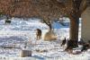
Jobs is definitely the biggest part. I'm a retired science teacher but my wife still teaches Spanish. She said if she can find a job, she would love to move there. Now that is one good woman! I do a lot of photography, esp. wildlife. The concentration of bald eagles there is amazing. My wife took a pic of me walking within 30ft of a bald eagle. The pic I got with my 300mm made my trip. Watching coyotes hunting out in snow covered fields, and wild turkeys just walking around town. The mule deer was on the deck of the candy store in town. When I shot the pic of the coyotes it was about 8am and 2f outside. I had all the windows down and George Winston blasting on the radio. I thought I had died and gone to Heaven. The weather is more than benign there too. They get pretty good wind storms from time to time, and thunderstorms. They had a big windstorm there last August that did some significant wind damage. But it's the cold and snow added to the stunning beauty of the mountains that draws me. I've been to Missoula (that keeps popping up in conversation for places to live) and I find the Methow more beautiful. The Methow R. had a lot of ice coming down it and that just added to the majesty of the area. The other thing that I loved was then it was in single digits and low teens and with the lower humidity, it was so much more tolerable, so much more than here. I went up to Sun Mountain Lodge for New Years and hiked above the lodge to shoot back. Handheld at 1 sec, I managed to get Saturn (top left) as a nice added bonus. Big difference in snow depth on the lower end of the Valley. Methow had just a few inches, Twisp (9 miles from Winthrop) had about 8", Winthrop had a solid foot and Mazama(15 miles or so up the valley) had almost 2' with not a lot of elevation gain from Winthrop.


 3 points
 -
Been under the heavy band since 5PM. I'll estimate close to 2.5" down... i'll go and measure as soon as it passes. This is a very fluffy type snow.2 points
-
Our grass is starting to pop. Makes me think it's gonna get coldish again.2 points
-
I took some time to look back on our mid-November cold wave. The seven consecutive freezes at PDX from 11/12-11/18 kept jumping out at me, so I did some research. Turns out November 9-15, 1978 was the last time that happened so early in the season. November 2000 was close, also reeling off seven consecutive freezes from 11/14-11/20. PDX also recorded their earliest maximum in the 30's since 1955, as well as the earliest instance of frozen precip with temperatures at or below 32 since 1955. East of the Cascades, it appears Madras tied their monthly record of -15 from 1955. This validates the RDM record of -19 pretty well. Madras recorded 10" of snow heading into the event and similar amounts fell in Redmond. Malheur Branch Experiment Station, a lower elevation warm spot in Malheur County, fell to -6 to knock off 1985 (-5) for the monthly record. John Day was neck and neck with 1955 for the coldest airmass this early in the season, bottoming out at 14/-7. Only 1955 (14/-9) compares, and no other year was even close.2 points
-
Yeah the EURO is better than the GFS.2 points
-
Some good members on the Canadian ensemble also. Hopefully we'll see something start to emerge over the next few days. Edit: The ECMWF looks ripe for retrogression late in the run also.1 point
-
We need some anti solar and anti elasticity logos on here.1 point
-
It's one of the four most important meals of the day!1 point
-
I'm surprised nobody else has commented on the 0z GFS.1 point
-
Hazelnuts where always big business in Marion County growing up. Over the past 10 years the number of acres of blueberries has exploded. Every year I see new orchards and blueberry bushes going in. When I was a kid there were 5 dairies within 2 miles of our farm. Now there are none. There were also a lot of marionberries, strawberries, and rasberries. My dad had 3 acres of Raspberries. Now its mainly blueberries. There is only one u-pick strawberry field in the area, it is kind of sad.1 point
-
Here's an interesting stats document for 2013. http://www.agf.gov.bc.ca/stats/YinReview/2013_Agrifood_YIR_Web.pdfI guess 2014 is too newly finished to have a review for it. It seems in 2013, Blueberries and Apples were the biggest sellers from BC. I believe I read the US was the biggest importer of BC's Fruit & Nut exports.1 point
-
At least the 0z GFS is legitimately chilly for the second half of the run. Even that is pretty rare in the last half of January these days.1 point
-
Watch for that late month arctic attack to hit and hold...and not come and go like it did last year with the PV. BTW, last year we had 2 back 2 back 40F days to date (Jan 10th/11th.). Sure last season the arctic air that did hit was intense, but in a matter of a couple days it receded. This year we are getting attacked by multiple arctic HP's during a given time frame which results in consistent cold. As we get more blocking to develop in this pattern, the sustained cold is going to do a number for the nation as a whole.1 point
-
No religion here, please.1 point
-
Nice pictures Tom! Well that would be a surprise to get some LES tomorrow.1 point
-
Jesse's gonna have an aneurysm.1 point
-
00z GFS sniffing out the pattern in the longer range with the potential for a couple big storms. First up, next Monday in the Plains, then a few days later another big storm in the Plains. This is what I've been talking about...Blocking + Energy, Equals wound up big dogs.1 point
-
Hit the three inch mark here in Buffalo Grove. After the snowstorms in the past week and a half Chicago is now back around average for annual snowfall. These 2-3 inch snowstorms start adding up after a while1 point
-
Looks like a lot of moisture with the arctic front. Should be heavy accumulations above 500'.1 point
-
Welcome! Thanks for posting...1 point
-
This happens in every storm lol, I'm still waiting for a storm with a stratiform orientation to the precip shield, amazing how these are always modeled pretty stratiform, but banding tends to be the main story.1 point
-
Doc Brown has nothing on Phil.1 point
-
Don't worry we'll probably have an arctic outbreak in one of the next 2-3 Decembers.1 point
-
In Back to the Future, Marty McFly travels back to November 1955, shortly before we had a major arctic outbreak, from October 1985 which was also shortly before we had a major arctic outbreak. In Back to the Future Part II, he travels to October 2015. Hmm.....1 point
-
Looking at numbers for Horse Creek at 3,400' in the Cascades, and it gives you an idea of how warm the mountains have been the last two January's. They averaged 52.7 degrees for the maximum last January, and are at 53.5 so far this month. Good luck building any sort of appreciable snow pack with that! They had 9 days in the 60's last January with a whopping 77 degrees under the mega ridge mid-month, the same ridge that brought a monthly-record 63 degrees to Government Camp. Horse Creek has already seen three days in the 60's this month with a peak of 71 on the 7th. Compare these numbers to a January that sees more in the way of cold onshore flow, like 2008. Monthly average maximum of 37.9 degrees and a peak of 58. Pretty profound difference.1 point
-
Tim, I guess you must have been out of the country this past week with that January starting warm statement!1 point
-
It's better, let's just say that. Key in situations like this is actually getting the -NAO to sustain...the +AAM response over the tropical Pacific will try and pump the East-Asian jet/Aleutian low after the wave-break/-EPO returns..need a downstream block to keep the cold air in western Canada during the possible retrograde, otherwise, lol1 point
-
Don't feed it.1 point
-
Notice the SE ridge and blocking showing up not only with the AO, but the NAO! This is a fired up pattern to blossom some monster storms at the time when the jet stream begins reaching its peak intensity. Get ready boys and girls!1 point
-
Back in late December I posted forecast 850's on the Euro Ensembles for Day 10-15 that lead us into the arctic blast for the first week of January. Now, check out what the Euro is showing now to close out January....interesting, ay???1 point
-
Perhaps, but it's just a coincidence IMO. What I'm getting at is the last half of the winter isn't necessarily doomed.1 point
-
Man, I could live on a regular diet of troughs like this. Summer troughs cool us down; winter troughs bring rain. LA was the sweet spot for the moisture. 8AM Rain 1.05 Month: 1.23 59°1 point
-
The 12z ECMWF is looking a lot better than the 12Z GFS through hr 168.1 point
-
16z HRRR still showing that band hitting the northern burbs as well...12z GGEM had the band north also...I think Geo's area may get 1-2" out of this actually.1 point
-
HRRR hinting at a mini band up this way later. Will see how that goes. Right now there's quite a bit of sun out.
 1 point
 -
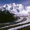
Looking west into the North Cascades.
 1 point
 -
Despite only about 15" of precip, average snow on the ground in Jan is around 20". The Methow doesn't scour out quickly, either. 15 miles up the road to Mazama you go from 70" of snow to 120" with little elevation gain, just closer to the mountains. When the snow comes it sticks around. Yea, it's isolated but the 100 mile drive to Wenatchee is pretty nice. Omak is roughly 5,000 people and has most of what one needs except social life, 30 miles from Winthrop. But if it's just weather your looking for, the Methow Valley is darn near perfect.


 1 point
 -
Wow, way up on Backbone Ridge eh?1 point
-
On the Canadian side of the border, Rossland, BC has a pretty amazing climate as far as climates in the PNW go. They average about 14ft of snow per winter with an average high of 27F in both December and January, and snow tends to come in the form of large storms with plenty cold clear days in between. They also tend to sit above the nasty inversion that can form in interior valleys. Summer temperatures there are almost identical to coast climates without the marine stratus and more thunderstorms. I used to go up there all the time when my grandparents lived there. The scenery is also very PNW-like, with large conifers and visible mountains: http://www.snow-forecast.com/system/images/13240/large/Columbia-Ave-in-Rossland_-Red-Mountain_-Michael-Fisher.jpg?13241524601 point
-
Of course there wasn't much else to do. Well I went fishing a lot....Like every day.1 point
-
I posted on here when I lived in Oklahoma.1 point
-
To each his own. Of course, in the midwest - I always had something on (heat or air). Could not open the windows more than a couple weeks a year it seemed. When I lived in various places on the north Gulf coast, very hot and humid 6 months out of the year followed by a nice and short shoulder season - with lots of dreary weather in the winter. Our springs -- not really all that bad - bright and cool with only light showers at times.1 point
-
I don't think its terrible. I don't think its always exciting, but its not terrible. I lived in Oklahoma. Their climate can be very exciting! But it is terrible.1 point
-
The article is obviously absurd. It was only a few years ago the Cascades were consistently seeing near record snowfalls pretty consistently.1 point

.thumb.jpeg.e3014abf99ef08a9f9ac2c0cd31b485b.jpeg)


This leaderboard is set to Vancouver/GMT-07:00