
Leaderboard


Popular Content
Showing content with the highest reputation on 08/31/17 in all areas
-
My climate forecast for the next 30+ years: http://i724.photobucket.com/albums/ww243/phillywillie/Mobile%20Uploads/BBBEF413-231F-4AB2-B64B-738EF4117EDF_zpsyckhusbg.jpg4 points
-
Snowcover is above average so far in the NH. https://www.ccin.ca/home/sites/default/files/snow/snow_tracker/nh_sce.png3 points
-
NH snowcover extent has started the season above average by almost +2SDs, thanks to a relatively cloudy, chilly summer in the high latitudes.3 points
-
Most Global Climate Models (GCMs) have had an estimate of temperature increasing 1.5 to 4.5 C with a doubling of CO2, with the primary source of uncertainty being clouds. Some GCMs have a strong positive feedback with clouds while others have a negative feedback. Some interesting work done recently by a professor of mine and others suggest that at least for the tropics there may be zero feedback, meaning the tropics are insensitive to changes in clouds. Since the tropics cover a large portion of the Earth this would mean that most likely the climate is on the less sensitive end of possibilities. Anyway, I thought it was interesting and whenever it is published I will link it here.2 points
-
Its been a pretty darn good Summer around here. Some heat, some storms, dry/cool spells. In a few hours met Fall begins. A few leaves have already changed color and have fallen. Im ready!2 points
-
Second August in recorded history without 90s. Last time was in 1915.2 points
-
Either 00z or 06z GFS (forget which) advertised a minimum pressure of 885mb. That'd be nearly historic.2 points
-
The astronomical calendar is VERY arbitrary in the sense that it "assumes" 1 1/2 months of seasonal lag across the entire year. It's mere happenstance that Western Oregon's summertime climatology comes within a few days of this definition. And of course it doesn't work at ALL during the winter. Off by a full month!2 points
-
It was a nice August in Lincoln! No 90s to speak of. Sadly this weekend will be hot in comparison to the past few weeks.2 points
-
Yes, they are accurate indeed. I like them also. They have me for the next two mornings at 44F and 48F. Ofc, Accu-Weather would be my last choice.2 points
-
GRR's beyond annoying and it's not even winter They're stuck in the "upper 40's mode", even though Marshall's had several mornings colder already this month. I find Intellicast's local 4-cast much more accurate. They have me at 45 and 46 the next (2) mornings.2 points
-
I am truly hoping for a chilly Autumn and a cold start to Winter and turning progressively very cold along with snowstorms, some massive.2 points
-
Very true, we may very well see that again if the PAC ignites. We'll see how it all unfolds this Autumn. I'm thinking the Aleutian Low will be very strong again this season. Just not to comfortable saying where it's location will be in the NE PAC.2 points
-
A moderate (-1.0C) Nina isn't all that bad to be honest and I think it would create a more favorable storm track for many of us and keep more cold into the U.S. In terms of weak Nina's, you will have to fight that SE ridge and unless you have blocking (which we didn't have last year), it may be difficult to have sustained cold. So, a mod Nina makes more sense in terms of making next season a winner.2 points
-
I believe that chilly air is coming south towards SMI later tonight as my lows will fall in the low 40s (40-45 to be exact).2 points
-
A strong SST gradient in PAC mostly caused the very wet Winter in California and the PAC last Fall and Winter.2 points
-
Meanwhile..lurking to our north.. How bout a mid-day temp of 48F to finish August? Up there, if summer falls on a Sunday, they host a community softball game2 points
-
k, totally a just for fun post here, but I knew something like this would happen sooner or later, just figured it'd be with a winter system. Since the upgrade, I've noticed the GFS mid-long range often projects the absolute "if everything under the sun aligns perfectly" scenario and runs with it Soooooo, this would ofc be horrible news if another major, let alone a MEGA hurricane came to the US coast after Harvey's devastation in TX. Thankfully, it's just the GFS being the GFS.. (we hope-gulp)2 points
-
Your going to need that blocking to really build across the Arctic or SSW's to see any favorable sustained cold. I don't think it could be any worse than last year!2 points
-
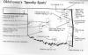
On the topic of spooky creatures in eastern Oklahoma, we have a few around here and there are still some not even on this old image.
 2 points
 -
I'm right there with Jesse... I've been over this heat for a while now. Ready for some rain and cooler weather. Please2 points
-
No rain again ever.2 points
-
Something to keep an eye on; some models [Canadian] suggest this moisture reaching California next week. NWS_LA
 2 points
 -
My temps are already starting to fall into the upper 40s. Its gonna be a chilly one.1 point
-
Dewpoint in Fullerton is higher than in Houston, which has literally become a swampland.1 point
-
It feels like Miami out there. There are storms all around us, but no rain here.1 point
-
I would like to see some tropical storm remnants bring some activity to Socal, like Dolores did back in July 2015. Hopefully it verifies!1 point
-
Sounds like you're up for the challenge!1 point
-
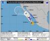
Insanity, if it even comes close...EPS is suggesting some members of 170+ mph winds for current major Cat 3 #Irma1 point
-
I was wondering why there was a smell of smoke in the air today when I left the gym. Canadian wildfires are to blame! http://www.chicagotribune.com/suburbs/elgin-courier-news/news/ct-ecn-elgin-canada-wildfires-st-0901-20170831-story.html1 point
-
Here are the ONI values back in 2007-2008: You can see it was a moderate Nina...in fact, we are trending that way on the CFSv2...1 point
-
I bet if you forwarded this to a bunch of news websites, at least a couple would be dumb enough to report this as a "new forecast."1 point
-
Yeah, I think I had my ENSO states confused (like Ma Nature last winter). Not sure the exact value of the Nina in 2007-08, but we rode the line of "too warm for snow" but it was wet and active if not terribly good for snowcover longevity peeps. I'd take that again in a minute for Marshall. However, I think our friend, Mr. -QBO will lend us a hand with blocking across Canada and a "boost" to cold plunges so that we get a result more like my stream line in red. As you said, helping more folks on here to get in the action. I think 07-08 was not good for many south of I-80.1 point
-
Looks like you are leaning toward the Tim index remaining positive.1 point
-
Looks like you left a little sliver of average temps along the immediate coastline of Washington. Hmmmmmmmmmmmmmm. You're not usually this confident this far out. I'm liking this, guys!1 point
-
In as many days during met Summer, the U.P. will open met Autumn with another Frost Advisory. This time, sharing some real estate with its second half of the state in N MI.1 point
-
Consensus seems to be building on the heatwave ending at some point.1 point
-
I will say, though, that the early September heatwave is going to be remarkable - IF smoke doesn't screw up the temps too much. An annoying reminder of why the "meteorological definition" of summertime doesn't always work out in our climate (since these kind of heat waves don't get counted).1 point
-
Dang, that is a hot forecast. Not too shabby for ND.1 point
-
It's going to be 94F on Sunday in Dickinson, ND, meanwhile at the same exactly latitude, Duluth, MN has only a high of 76F on Sunday. http://www.city-data.com/forum/attachments/weather/189685d1504193679-autumn-fall-2017-thread-sept-oct-dickinsonndwxforecast.png http://www.city-data.com/forum/attachments/weather/189687d1504193730-autumn-fall-2017-thread-sept-oct-duluthmnwxforcast6.png1 point
-
Will do!1 point
-
If that holds up, you guys up there are in for a great winter. Too far east to do me much good. Instead of fighting the SE ridge, I will be fighting the SW ridge if that verifies.1 point
-
Lol. To the contrary, I think we've mostly seen the last of this regime dominated by +NAM/+NAO during boreal winter. This winter, I suspect, will finally deliver the transition into a low frequency -PNA/-NAO regime, much like winter 2012/13 featured the transition into +PNA/+NAO. Will probably start with a major midwinter SSW and destruction of the circumpolar vortex, much like what happened in January of 2013.1 point
-
I never knew you to be such a stickler for averages.1 point
-
The stats I referenced were for a two month stretch (Jul-Aug 2013), and for a season (98 degree days in 2016, all of which occurred during JJA). Not to be confused with statistics for individual heat waves.1 point
-
Strange statement coming from someone not wanting others to speak for him.1 point
-
Question for the statman... what are the warmest 40 day stretches on record for PDX? Does this year's 7/31 to 9/8 have a chance for #1?1 point
-
Hot and humid now, but in a few weeks we could get our first Santa Ana Winds, which would make it hot and dry. Would be nice to see some monsoon activity west of the mountains.1 point
-
Reports of some rain activity but nothing close by but cumulus & heat 98/ 70
 1 point


This leaderboard is set to Vancouver/GMT-07:00