
Leaderboard


Popular Content
Showing content with the highest reputation on 11/17/15 in all areas
-
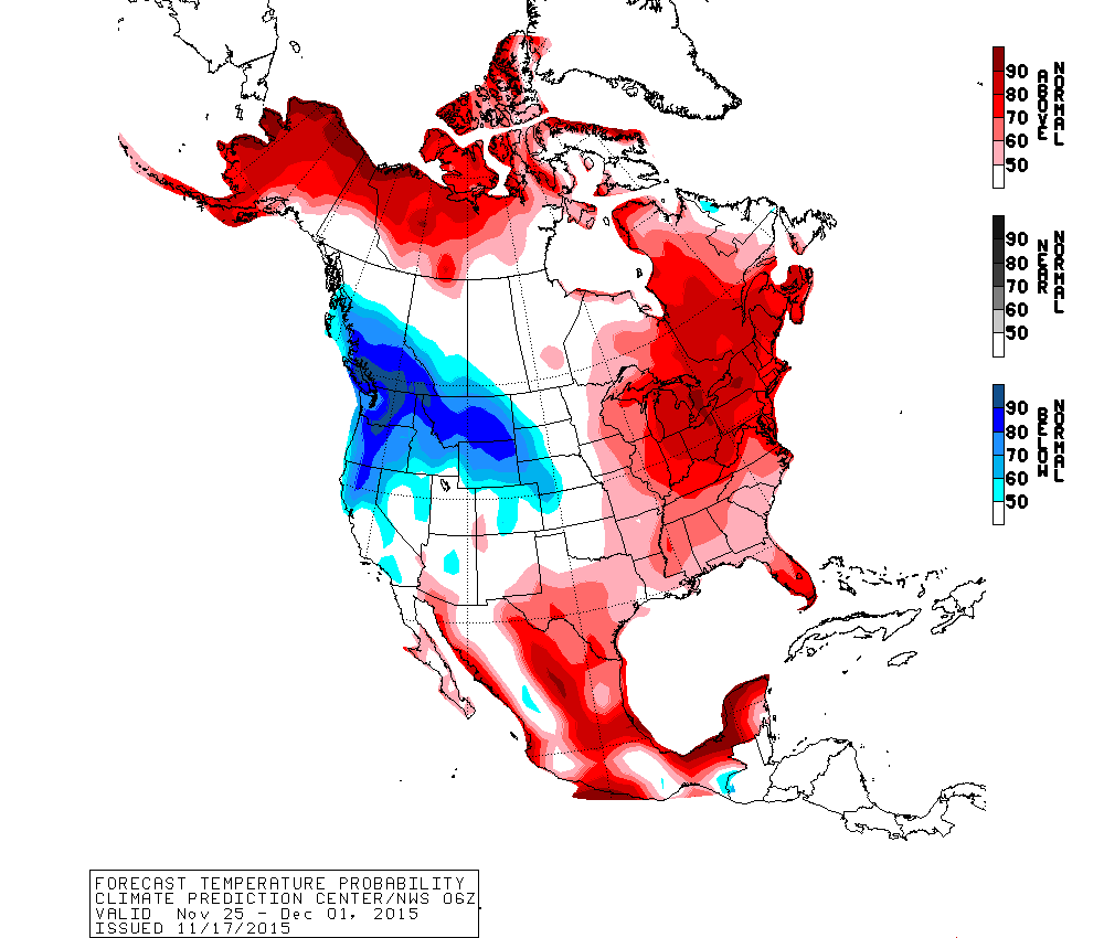
Pretty strong signal for a developing cold snap here. 70-90% probability of below average.
 3 points
 -
Neat Tweet from the astronaut Scott Kelly...can you spot the Great Lakes??? 00z Euro Ensembles for the system around Thanksgiving Day showing more snowy runs from the Plains/Midwest/Lakes. Week 2 starting to show more troughing in the southern Plains. @ OKwx2k4, there are signs your Winter season may be starting very late this month.3 points
-
Hey everyone. I used to be a member of this forum back in 2008-2009. Learned a bunch just from lurking around. I have since moved from western wa to eastern wa, specifically Fruitland. My elevation is 2,359. Today was an eventful day, windy all day and picked up substantially as the day led on. Highest gust was 74 at my house. This time last night it was 28 degrees and snowing, woke up to 2" of snow melting very fast as the temp had climbed up to 39 by 7am. By noon it was all gone and dry and sustained 40 mph winds gusting to 60 or so. I am stoked to see what this winter has in store as we are in a very strong El Nino pattern from I have learned recently. What are your guys' predictions for major events over here? I appreciate it.2 points
-
Fantasy Land GFS...this would be awesome to have this much of the country covered with snow to open up December...let the pattern load up!2 points
-
I was just put in a winter weather advisory. Could be greater than 6 inches in places. One site just updated 5-8 inches. Winter Weather Advisory in effect until 6 am CST Wednesday... The National Weather Service in Hastings has issued a Winter Weather Advisory... which is in effect until 6 am CST Wednesday. * Impact... snow accumulation combined with strong north winds will result in reduced visibility that at times could fall below one-half mile... making travel difficult. * Snow accumulation... generally 2 to 5 inches. Expect wide variability in snow amounts and perhaps locally greater amounts near 6 inches. * Timing... rain will gradually transition to snow this afternoon and evening... with periods of sleet possible. The majority of snow accumulation is expected after 9 PM. * Uncertainty... there will be a potentially very narrow band of heavier snow. Snowfall amounts may deviate from current expectations. * Winds... from the north-northwest at generally 20 to 25 mph and gusting at least 30 to 35 mph. * Wind chill values... averaging around 20 degrees. Precautionary/preparedness actions... A Winter Weather Advisory for snow and blowing snow means that visibilities will be limited due to a combination of falling and blowing snow. Use caution when traveling... especially in open areas.2 points
-
Of course I am! Ready as always, let's hope it's an active winter!2 points
-
Yes! Tom I just saw the new epo charts. Holy moly! They need to extend the chart on the bottom end. Lol. The November 29-December 2 time frame has a whole lot of interest for my area. I'm glad a lot of you are going to get to see some good white stuff here before long.2 points
-
**sees storm track, desperately tries not to complain about dry slot like typical nebraskan**2 points
-
Too far out to sweat the details, but at least all of the models are now spitting out some runs with real potential for Thanksgiving week. Euro has led the way so far.1 point
-
It was obviously way worse up there than it was here. December 2006 was MUCH worse here than this event. Very interesting about the stilly. Huge flooding on that one and the Skagit seems to be the best harbingers of a coming Arctic outbreak. There must have been enough snowpack to exacerbate the flooding this time.1 point
-
Yes indeed. Given how much better the other models have been I expect the improving trend will continue. Jesse has to be pleased there is basically no warm weather being shown over the next 10 days at least. I know I sure am.1 point
-
I know. Like I said, I'm pretty sure no one here considers you a liar, including dewey. You are definitely all those other things.1 point
-
Stupid phone1 point
-
Lol. Me too. It could be like a January '78 storm.1 point
-
116 mph gust at mission ridge ski resort. Not to bad.1 point
-
Too far north. :-(1 point
-
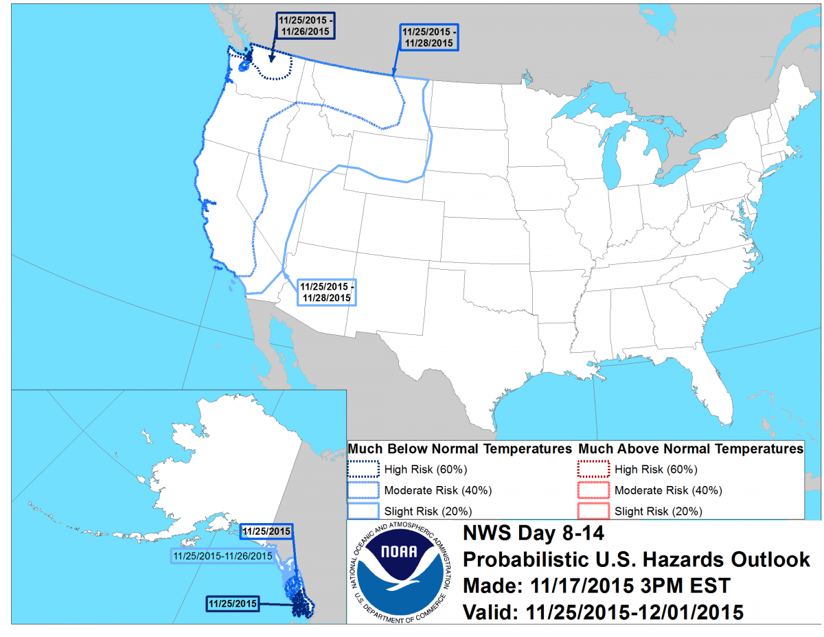
This was the tab that surprised me. NOAA rarely posts 8-14 day hazards for our area especially for cold anomalies since it takes the perfect setup for the northwest.
 1 point
 -
Would still take this.1 point
-
It just opened today. IBR wants to drink my fermented tears at a BBQ apparently.1 point
-
Nice looking run from the Euro!1 point
-
We need it man.1 point
-
I notice that a pretty selective deletion of posts occurred in this transfer.1 point
-
Yeah, GR is gonna be golden for early season LES. They're the perfect distance. Gonna cash in big time with the warm water temps. Heck, I even think mby (80 miles inland) has a shot at a decent LES event or two the way this season is shaping up. Let the games begin!1 point
-
I'm always right.1 point
-
This storm is heading towards my thinking from the beginning. 12z Euro has it really trying to amp up as it heads into S IL/S IN/OH...more precip gets wrapped into this system near the Lower Lakes...it ends up spinning up into a 994mb SLP just NW of Buffalo. Edit: Speed max looking more healthier this run...1 point
-
Correct me if I'm wrong, the comma head is currently undergoing formation?? Another deformation zone is setting up right over central/western nebraska? This is crazy, but I would think for sure this storm system would have rung itself out by now! Looking at the national radar, its impressive seeing the stream of precip out in front of the low, and another area of precipitation forming over nebraska.1 point
-
I'm guessing the 12z run didn't show that Black Friday transistion event?1 point
-
4km NAM in your favor CNW! Gabel might get snow accumulation now. Cold air is pressing more south and east.
 1 point
 -
That is getting close. We are currently 37 degrees with a north wind of 30 with gusts in the upper 30's and a steady sideways rain falling. Radar showing snow about 1 county southwest of me. Seems like NWS Hastings still is thinking that this band is moving farther east than they are forecasting and may add more counties to the advisories. NWS Hastings: please bear with US as some noticeable adjustments are possible by upcoming day/evening shift as the ultimate position of the main deformation band finally shows it's hand. Please emphasize that counties adjacent to the existing advisory (such as Buffalo for example) may ultimately need considered for advisory expansion depending on how things play out.1 point
-
Much of the south Denver area did. Where I live in the NW burbs, only 3". I work in Boulder, and they barely got anything! Yet I-25 just south of Denver was shut down because of blizzard conditions for awhile this morning. Crazy storm.1 point
-
Yup, 06z GFS onto something...EPO off the charts that run!1 point
-
According to the newest installment of the JMA, this may be what it is showing. Has a NW to SE tilt to the Aleutian low which would most likely pull the ridge back over the top. http://ds.data.jma.go.jp/tcc/tcc/products/model/map/4mE/map1/zpcmap.php1 point
-
I caught James Hansen taking a warm, stinky poo on the ORD sensor equipment while I was there once for business during a cold period.1 point
-
It's just warm enough (33 at my house) that if this storm were occurring during the day, there wouldn't be much sticking to the roads at this point. As it is, I'm sure they'll be a mess in the morning, especially with the winds. 1.5" here so far. Definitely blizzard conditions in Cheyenne, with sustained winds of 30 and gusts to 45: http://w1.weather.gov/data/obhistory/KCYS.html1 point


.thumb.jpeg.e3014abf99ef08a9f9ac2c0cd31b485b.jpeg)


This leaderboard is set to Vancouver/GMT-07:00