
Leaderboard


Popular Content
Showing content with the highest reputation on 12/17/15 in all areas
-
The mountains are going to get epic snow over the next week. 7-8 feet over the next 8 days.4 points
-
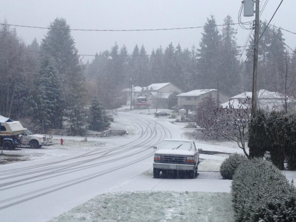
32F with moderate snow here now. About 1/2" accumulation.
 4 points
 -
Why not?? Most places with a real winter are bone cold and dry when you get right down to the brass tacks. I'll take -15F and a stiff NW wind any day over the crap/humid/heat of IA in late summer. (and last winter was anything but frigid-- near normal). I don't lose/break even/ or win when it comes to the heat bill-- cuz I don't got one PERIOD. I burn wood 95% of the winter-- and when the wood stoves are not running its cuz I'am cleaning out the ashes. This MN boy loves a cold winter. Ice Fishing/ winter camping-- love it!! The 3-5" of rain the other day-- not so much. The mud was disgusting .4 points
-
Winter wx advisory upgraded to winter storm warning. 4-7" forecasted now. Been snowing almost an inch per hour the last couple.3 points
-
I really like this. This has "snowstorm" written all over it.http://www.tropicaltidbits.com/analysis/models/ecmwf/2015121712/ecmwf_T850_namer_11.png3 points
-
CPC says Giddy-up3 points
-
Starting to accumulate now. Temp down to 33F. First snow I have seen in over a year. Hard to believe considering we average a little over 30".3 points
-
Nothing just keeping everyone on their toes2 points
-
HOLY CRAP GUYS!!!!! [had to ramp up the enthusiasm] 24 degrees here and blowing snow!....yeah blowing powdery snow! I've never seen blowing snow in WA before. Seen it plenty whilst driving/working in Wyoming & Colorado. Accumulation appears to be 2" and still snowing, but it's blowing around (no drifts...yet). Heavier bands of snow come and go. The roads are white, not compact snow and ice, but rather just white. Whatever sticks, sticks, and the rest blows away. I am guessing the wind is 10 mph with the occasional 15-20mph gust....it's really something to see the snow blowing off of my metal roof and across the road. I'm totally psyched about this. Cant wait to get the quad out tomorrow and tow the kids on the sled behind it haha. Can't really make snowmen out of powder, kids will learn that real quick in the morning. And to think....the locals are calling this a "mild" winter so far. Sheesh, can I see what a "non-mild" winter event is like? I am looking forward to it. That wakeboard boat we have in the garage is looking more and more like a couple new snowmobiles.....naww, I'll keep the boat for the awesome summers we have over here! Haha, so happy we moved over here. (I Feel like a weenie for being so psyched up about this little event here)2 points
-
http://www.komonews.com/weather/blogs/scott/Poll-Seattleites-narrowly-prefer-sunny-hot-weather-to-rainy-windy-weather-362841441.html Totally F'd up. What is wrong with people???2 points
-
Here's the ensemble mean for days 6-10. My guess would be most members are generally supportive of the operational solution.2 points
-
I just looked, figured it couldn't have been bad or else Tim would have posted it. It looks like the Euro.2 points
-
The rebuilding ridge on day 10 is quite a bit stronger than previous runs and at a great spot. Hopefully it builds northward. Pretty good looking run!2 points
-
I don't hate this. http://www.tropicaltidbits.com/analysis/models/ecmwf/2015121712/ecmwf_z500_mslp_namer_8.png2 points
-
I know! Guess we need to petition Fred about an allowed number of "likes" increase!!2 points
-
Expecting 4" tonight with freezing rain. Sitting at 19F.2 points
-
I like this I definitely like this Nice. I like this I like the knowledge, but I don't like the massive, consolidated PV2 points
-
I think part of the excitement and the fun for me resides in the fact that at least something sort of interesting is happening (Huge mountain snows, tons of lowland rainfall, mini surprise lowland wet snow non-event), and something interesting is at least possible in the future (more epic mountain snow, possible lowland snow, no sign of death ridge etc,). When this community is active, it almost feels enchanted. I just hope we can all come out of this winter with something to hang our heads on.1 point
-
This could bode well for a high impact event before a more typical Nino regime kicks in. I've had a suspicion the coldest weather may come just before that shift occurs. If we're lucky we may go from a major cold wave right into a big ridge that would keep the surface cold for quite some time.1 point
-
Hell yes.1 point
-
The MJO is non existent right now but tropical forcing overall is helping us indeed1 point
-
WHAT IS IT?!?!?!1 point
-
00z GEM is like the GFS, but it keeps the ridge/positive anomaly near the Aleutians for cold air potential beyond day 10 too.1 point
-
(we lived on a sloping hill)Fortunate break that you had a sloping hill. Those are much better for sledding than a typical flat hill.1 point
-
Blowing snow is the best. I'll never forget the V-Day squall last winter...4" in 25 minutes w/ 60mph winds.1 point
-
What you said in bold there is how I feel about the 1996 storm. I was in sixth grade and remember my mother making a snow dog in the front yard, yes a snow dog....she misted it with warm water from a spray bottle so it would ice over and last longer. Meanwhile my father was busy towing the neighborhood kids and I around behind our three wheeler (good ol' 85' Honda ATC 185..). Freezing rain was also a part of this, if I remember correctly, and thats when the power lines came down and things got ugly real fast. Power was out, we resorted to using a kerosene heater to heat our house for 7 days. Had to keep every window in the house cracked about a quarter inch, thats when I learned about the dangers of carbon monoxide (that killed so many dummies that used BBQs to heat their house during the Hanukkah eve storm 06'). In the end, it was an awesome experience that I will cherish forever. It's also what sparked my interests in the weather as well. From that point forward I was always glued to the window whenever that thermometer read below 32*.....Growing up in western wa, I was let down allot though. Nowadays, my family and I are able to enjoy the luxuries of living in a place with 4 REAL seasons....1 point
-
Indeed. I was but 9 years old, and it was the storm that truly sparked my interest in weather. My school had a Christmas program that night, the last day of school before winter break. There was no snow when the program started, but from the stage I could look out through the back windows of the building and saw when it started snowing...I remember seeing it blow sideways, and swirl around in the wind. Two hours later, we stepped outside into a winter wonderland. The drive home was treacherous, with lots of cars off the road, especially on the hills. Once home, we turned on the news and saw reports from around the area about the storm (SIBERIAN EXPRESS!!). Lots of places lost power but we didn't. The next day was frigid and everything, even all the roads, were covered in a thick layer of snow. The neighborhood kids and I sledded up and down the street (we lived on a sloping hill) all day. It was glorious. Sadly, I came down with chicken pox the next day, and had to watch all the other kids having a blast outside the next few days while I was stuck inside.1 point
-
Arctic express 2015. I can still remember 1990, what a storm.1 point
-
Seven degrees colder and things could be VERY interesting. Minor tweaks.1 point
-
Hard to not like the ECMWF. Beyond day 10 the ECMWF ensemble keeps prolonging the favorable pattern. The ECMWF based snowfall graphics on Weatherbell indicate widespread lowland snow just before Christmas with cold enough temps to keep any snow that falls around for a while.1 point
-
NE Canadian border in Whatcom has done well with the first snowfall of the season. My area ended up getting 2 inches of snow with some snow cover on the main road. The outflow winds were stronger than expected. Still some light snow in the air right now.1 point
-
Not snowing here yet, but sitting at 22 degrees, STILL! It was 22 @ 6am this morning! Something else I'd like to point out is the frost covered trees in the distance from my house. Theres a foothill called Miller Mountain that I can see from my house....as soon as there was enough daylight this morning, I could see the tops of the trees frosted over with what appears to be freezing fog. As the morning progressed, I have noticed the frost getting lower and lower and lower...... until now the tops of trees on my property shroud the trees in the distance, unable to see where the frost stops. Its pretty neat to observe this. I am curious though, what does this mean? Does it indicate falling snow level? Or just that the fog is increasing in density? Obviously its a few degrees colder up there (difference of ~500 feet)....but would that be enough for the right conditions to exist to allow freezing fog to stick to everything up there and not down here on my property?1 point
-
12z Euro has similar temps to 0z run, but looks like there would be more moisture. Definite white Christmas possibilities for some people with this run. Also, -20C into western MT at day 9.1 point
-
wow, 12z euro is much improved over its 12z run yesterday and the gfs this morning. I don't care if it is an all out blast, still could produce what we want to see.http://www.tropicaltidbits.com/analysis/models/ecmwf/2015121712/ecmwf_z500_mslp_namer_9.png1 point
-
Sorry...couldn't resist. 7yrs ago today. URGENT - WINTER WEATHER MESSAGE NATIONAL WEATHER SERVICE SEATTLE WA 400 AM PST WED DEC 17 2008 ...A WINTER STORM WARNING IS IN EFFECT FOR TODAY THROUGH THURSDAY MORNING FOR MOST NORTHERN ZONES IN WESTERN WASHINGTON AS WELL AS THE CASCADES AND OLYMPICS... ...A WINTER WEATHER ADVISORY IS IN EFFECT FOR TODAY THROUGH THURSDAY MORNING FOR SOUTHERN ZONES IN WESTERN WASHINGTON... .A FRONTAL SYSTEM WILL MOVE OVER WESTERN WASHINGTON FROM CANADA TODAY...AND WITH A VERY COLD AIR MASS STILL OVER THE REGION...SNOW IS EXPECTED ACROSS ALL OF WESTERN WASHINGTON TODAY AND TONIGHT. A COLD UPPER LEVEL LOW WILL REMAIN OVER THE AREA THURSDAY. SAN JUAN COUNTY-WESTERN WHATCOM COUNTY-EAST PUGET SOUND LOWLANDS- WESTERN SKAGIT COUNTY-EVERETT AND VICINITY-OLYMPICS- EASTERN STRAIT OF JUAN DE FUCA-WESTERN STRAIT OF JUAN DE FUCA- NORTH COAST-WEST SLOPES NORTHERN CASCADES AND PASSES- WEST SLOPES CENTRAL CASCADES AND PASSES- 400 AM PST WED DEC 17 2008 ...WINTER STORM WARNING REMAINS IN EFFECT UNTIL 10 AM PST THURSDAY... A WINTER STORM WARNING REMAINS IN EFFECT UNTIL 10 AM PST THURSDAY FOR MOST OF THE NORTH PART OF WESTERN WASHINGTON...AS WELL AS THE OLYMPICS AND CASCADES. IN WESTERN WHATCOM COUNTY...SAN JUAN COUNTY...AND WESTERN SKAGIT COUNTY...2 TO 5 INCHES OF SNOW IS LIKELY TODAY. SNOW HAS ALREADY BEGUN AND WILL CONTINUE THROUGH THIS AFTERNOON. SNOW SHOWERS WILL CONTINUE INTO WEDNESDAY NIGHT WHEN ANOTHER INCH IS POSSIBLE. TOTAL SNOW ACCUMULATION WILL BE 2 TO 6 INCHES. IN THE STRAIT OF JUAN DE FUCA AREA...UP TO 3 INCHES OF SNOW IS LIKELY TODAY. HIGHEST ACCUMULATIONS WILL BE AWAY FROM THE STRAIT. RIGHT ALONG THE STRAIT THE WARMER AIR WILL PRODUCE THE LOWEST ACCUMULATIONS AND THE SNOW MAY BE MIXED WITH RAIN AT TIMES. ANOTHER 1 TO 3 INCHES OF SNOW IS EXPECTED TONIGHT AS NORTH TO NORTHEAST WINDS CAUSE UPSLOPE SNOW TO DEVELOP. TOTAL SNOW ACCUMULATION WILL BE 2 TO 6 INCHES. IN THE EVERETT AREA...2 TO 5 INCHES OF SNOW IS LIKELY TODAY. LIGHT SNOW HAS ALREADY BEGUN AND WILL CONTINUE THROUGH THIS EVENING BEFORE CHANGING TO SNOW SHOWERS. IT LOOKS LIKE A PERSISTENT BAND OF SNOW WILL DEVELOP THIS AFTERNOON AND CONTINUE THROUGH THIS EVENING THAT MAY PRODUCE HEAVIER SNOW AMOUNTS...PROBABLY OVER THE SOUTHERN PART OF THE AREA. ANOTHER 2 TO 3 INCHES MAY FALL OVERNIGHT. TOTAL SNOW ACCUMULATION WILL BE UP TO 8 INCHES. IN THE EAST PUGET SOUND LOWLANDS INCLUDING CITIES SUCH AS BELLEVUE...ISSAQUAH...NORTH BEND...AND BONNEY LAKE...2 TO 6 INCHES OF SNOW ARE LIKELY TODAY. SNOW FLURRIES HAVE ALREADY BEGUN AND HEAVY SNOW IS EXPECTED AFTER 7 AM. THE HEAVIEST SNOW AMOUNTS WILL BE NEAR THE CASCADES...AND OVER THE NORTH PART WHERE A PERSISTENT BAND OF SNOW MAY DEVELOP. ANOTHER 2 TO 5 INCHES WILL FALL TONIGHT. TOTAL SNOW ACCUMULATION WILL BE 4 TO 10 INCHES. ON THE NORTH COAST...UP TO 4 INCHES OF SNOW MAY ACCUMULATE TODAY. THE HIGHEST ACCUMULATIONS WILL BE INLAND CLOSER TO THE OLYMPICS. NEAR THE COAST TEMPERATURES WILL BE WARM ENOUGH SO THAT THERE MAY BE SOME RAIN OR RAIN AND SNOW MIXED. ANOTHER 1 TO 3 INCHES OF SNOW MAY FALL TONIGHT...ONCE AGAIN WITH HIGHEST AMOUNTS FURTHER INLAND. TOTAL SNOW ACCUMULATIONS WILL BE UP TO 7 INCHES. IN THE OLYMPICS AND CASCADES...ONE TO TWO FEET OF SNOW SNOW WILL FALL THROUGH LATE TONIGHT. THE HIGHEST AMOUNTS WILL PROBABLY BE JUST NORTH OF OR NEAR THE STEVENS PASS AREA...WHERE A PERSISTENT BAND OF SNOW IS EXPECTED TO DEVELOP. ALTHOUGH THE HEAVY SNOW WILL END BY THURSDAY MORNING...SNOW SHOWERS ARE POSSIBLE THURSDAY. TEMPERATURES ARE UNLIKELY TO CLIMB MUCH ABOVE FREEZING ON THURSDAY OR FRIDAY...SO NOT MUCH SNOW MELT WILL OCCUR. PRECAUTIONARY/PREPAREDNESS ACTIONS...MONITOR WEATHER FORECASTS AND ROAD CONDITIONS CAREFULLY. STAY INDOORS IF AT ALL POSSIBLE. TRAVEL IS LIKELY TO BE ADVERSELY IMPACTED WEDNESDAY INTO THURSDAY AND POSSIBLY LONGER.1 point
-
If you read back his prediction on the 10th was "good chance of snow around the 18th. that snow will not be there on christmas." He didn't say it won't snow on christmas, but that todays snow would not be there then.1 point
-
Well then I am quite disappointed he hasn't posted any pictures yet! Just looking out the window here at my work it looks like some lumpiness is also dropping with the moderate rain now.1 point
-
36 and a little bit of chunky rain at times here at 550ft. A few splats on my windshield but that was it when I was driving. Considering I left nearly a foot and a half of snow...*snore*. I actually am liking this though, I kind of missed the gloomy days. My sister in London has been complaining about how warm its been. Right now she's skiing in the french alps and only 1/5th of the trails are open because there isn't enough snow and it's in the mid 40s. Good thing there is a glacier they can ski on.1 point
-
Hearing reports of light snow in NW Whatcom County. Just rain here 3 miles NE of the Airport in Bellingham.1 point
-
It is probably snowing at TT's house. Just talked to a friend in North Bend, and he is reporting rain/snow mix occasionally.1 point
-
And... it's snowing in Vancouver!1 point
-
Well the Gorge snow happened. 33 degrees with .50" of precip falling as snow so far at The Dalles. Looks like the Gorge floor should avoid ZR too.1 point
-
6z GFS Ensembles 850mb mean temps about the same. The only changes I note were the new cluster of -5c to -10c after December 27th. Would like to see that increase and to get rid of the warmer members. 500mb anomalies a touch better. Oh, I tried to ' like ' a few posts, but I got this prompt instead An error occurredYou have reached your quota of positive votes for the day. ------------------------------------------- Now how am I supposed to show my agreement or like for other members comments, analysis, or whatever, if I can't do that. It'll be a rough day for me, but I'll get through this somehow. Onto 12z! 12z GFS in 44 minutes 12z GEM in 1 hours 44 minutes 12z ECMWF in 3 hours 6 minutes1 point
-
Yeah, this isn't responsible for the progressive nature of the pattern. Just a normal early-winter PV, correct? What a monster. (Image credit: Michael Ventrice/WSI)
 1 point
 -
It is snowing at The Dalles. 33 degrees.1 point
-
Question is, will the tropical forcings still favor NPAC height rises by the time it breaks up (mid/late January)?1 point
-
The bottom line is that things haven't really trended towards a meaningful pattern change at this point. We're a ways off still. The real story has been and will continue to be the filthy amounts of rain, either though it's understandably far less enticing a discussion to have. Also, in looking at our wettest Decembers on record, there's really no clear signal. Big mixed bag of patterns the rest of the winter. Decembers like 1996, 1955, 1933, 1917, 1882, and 1867 really stand out for their rain and there's some huge contrasts there in JFM.1 point
-
I feel like Jesse's spirit lives on inside of you. Since he has been gone, you have become extra pessimistic and cynical.1 point
-
Way to go, Tim! Ever vigilant. There are differences from a week ago. Much better model consistency (aside from the Canadian) over the last couple days, for one thing. Also, much better cold air source potential in North America. No model was showing anything close to the air mass the models are showing for AK/Yukon/BC now. But hey, let's just ignore that because weenies were being weenies a week ago, as they always are.1 point
-
We appreciate your taking one for the team here. Your absence is tilting things in our favor.1 point
.thumb.jpeg.e3014abf99ef08a9f9ac2c0cd31b485b.jpeg)


This leaderboard is set to Vancouver/GMT-07:00