
Leaderboard


Popular Content
Showing content with the highest reputation on 02/12/20 in all areas
-
Currently flying over the Quad Cities area. If the flight turbulence is any indication, you peeps downstream here are in for a decent storm. Nice convective look to the cloud tops. Good luck all.8 points
-
20 degrees dropped here in about 50 minutes, also snowed at a good clip for about 20 minutes6 points
-
Same here...it's rippin'! I'm under a nice band right now...big flakes and moderate snow ATM...6 points
-
4" in McPherson,ks at my parents be (my dad posted on Facebook)
 6 points
 -
Crunched a few numbers and put my CALC 6 to use and the front is barrelling Southerly at avg speed of 25-30 mph. Yesterday at 6AM it was at about 56N latitude Today at 6AM it was roughly at the 46th latitude. Cool how consistent in speed it has been.6 points
-
Yes heavy snow, temp of 33 and nearly 2 inches already. Very beautiful!6 points
-
Cold front has just passed through here. Now let's see how fast the temperature tanks. So far it's down about 10 degrees in 20 minutes.5 points
-
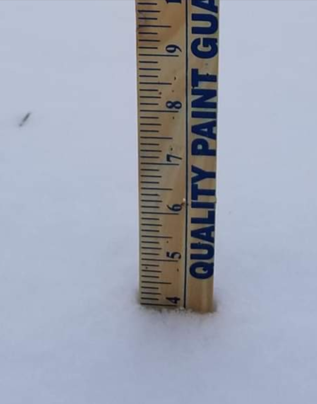
Had a little break in the snow but flakes are flying again. 3.5 inches of wet snow on the ground,5 points
-
Nanook will not invade my house!! Kept upstairs 68-78F since NOV- fire going constant downstairs since NOV. I don't like flipping switches / prefer striking matches.( the Wife is the opposite- imagine that) Love a challenge of keeping Nanook at bay. Much easier than opposite come July. UGH!5 points
-
Certainly has here. I already have 3 inches otg.5 points
-
D**n- that's some contrast.5 points
-
Currently -17F with a wind chill of -49F in Lancaster, MN on the Canadian border. Still 31F here. Skies now overcast as the front makes its move.5 points
-
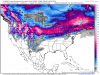
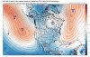
There are 3...ok, maybe 4, LR tools in the extended period that suggest Winter may in fact be on the verge of a late season comeback...back loaded??? While not necessarily cold, the potential storm track and residual cold that is available in this pattern may lead us into many more winter storms to track before all sudden done. I'm beginning to see some rather fascinating trends towards the last week of Feb and especially as we get into March. March may "roar" in a Lion this year as I am predicting an active SW Flow out of the 4 corners region. Here are a few things that stand out to me as we progress through the final month of met Winter. First, and foremost, the location of the 30mb warming across NW NAMER in the animation below is an early indication that the pressure pattern over this region should flip and show more HP right around the beginning of the last week of Feb. Second, all the models are trending towards a neutral PNA and a reversal of the sky high (+) EPO and potential (-) EPO...see maps below.... Third, as the jet begins to weaken towards the end of the month, based on the GEFS 10mb strat forecasts it is suggesting a "suppressed" STJ roaring into Cali and the southern part of the west coast. This may be the beginning of a significant pattern change for the desert SW/4 corners region as we head into March. The LRC's most active storm track had storms forming in the "slot" near the TX Panhandle quite often this year. I have a gut feeling as the jet weakens and more blocking/ridging develops in the places where it did during the 1st LRC cycle, I believe it will actually develop later this month into March. Fourth, the CFSv2 weeklies have that "look" to close out Feb and open March that say...look out baby...I see you "Blizzard Alley"....are we in for a late season rally???
 5 points
 -
Have around 4 inches otg, would have had more but the snow stopped for a few hours this afternoon and temps rose. Expecting another inch or so later this evening before the front dries me out.4 points
-
It literally snowed 6 inches today in KC. The best snowfall rates all winter long. However, 33-35 degrees and during the day, officially KCI(official reporting station) only recorded 1.3 inches. I actually got up to 2.1 at 4pm today on my snow board in north KC. No pavement accums. Not done, arctic front is on the move and a second disturbance is moving in this evening. Could see an intense line of snow with the arctic front...HRRR has been showing this. 1-2 inches is possible and with it being night, we just might finish this with a bang. 40 mph winds too Nice winter day nonetheless!!!4 points
-
Just barely reached 32-33F around here this late pm. Snow shield looks large and perhaps a bit N. Let's roll wit-it4 points
-
Tom, are you trying to draw me in after I threw in the towel last week? Darn you Euro, now I'm back to tracking. The fun of weather.4 points
-
The other models are all trending toward the Euro for next week's system. The other models had been emphasizing a northern piece of energy that runs out ahead and ruins the system, but this morning they are nixing that idea.4 points
-
The 12Z ICON and GFS look like they might try to put a system together in the Central Plains early next week, but it just doesn't quite do it. Euro has been on to this system for a couple of days. We'll see what transpires.4 points
-
Heavy snow is falling. I was surprised at how quickly it began to accumulate. I have a temp of 32, I think the sun angle was made to big of an issue by some as it is only Feb 12th not March 12th. This could have a chance to overachieve.4 points
-
Cloudy and 32 this morning. Radar is looking good with some heavy echos to my south moving my way. Hope to land another 3in event which has been the theme this year. Good luck to everyone today and tomorrow,4 points
-
Grand Forks airport has had 3 consecutive hours with winds easily gusting over 50 mph-- 13" of snow on the ground = that would be awesome. Peak Gust 53KTs = 61mph. Gotta love the Northern Plains. KGFK 120953Z AUTO 35036G50KT 1/4SM R35L/1600V2600FT -SN FZFG VV005 M17/M18 A2983 RMK AO2 PK WND 36053/0855 SLP121 P0004 T11671183 $ KGFK 120951Z AUTO 35036G46KT 1/4SM R35L/1600V2200FT -SN FZFG VV005 M17/M18 A2983 RMK AO2 PK WND 36053/0855 P0004 $ KGFK 120853Z AUTO 35034G48KT 1/4SM R35L/1400V4000FT -SN FZFG VV006 M13/M15 A2978 RMK AO2 PK WND 35049/0759 SLP100 P0000 60001 T11331150 53047 $ KGFK 120806Z AUTO 35029G49KT 1/4SM R35L/1800V2800FT -SN FZFG VV005 M11/M13 A2972 RMK AO2 PK WND 35049/0759 P0000 T11111128 $ KGFK 120748Z AUTO 36035G48KT 1/4SM R35L/1200V2200FT -SN FZFG BKN006 OVC020 M10/M12 A2970 RMK AO2 PK WND 36049/0733 SLP074 P0000 T11001117 $ KGFK 120553Z AUTO 25007KT 3SM -SN OVC029 M02/M05 A2963 RMK AO2 SNB02 SLP048 4/013 P0000 60000 T10171050 11011 21039 410111128 530024 points
-
We are getting a nice burst of snow now and it's finally beginning to accumulate. The cold front it easily visible on the Des Moines radar.3 points
-
Heaviest snow falling right now, would love to get a couple more inches.3 points
-
Can't wait to move back to the Plains. I miss those wild temp swings.3 points
-
Currently 40 degrees and getting some big heavy wet flakes. That has to be some cold air aloft.3 points
-
I'm liking the spread of the precip shield. Definitely a bigger storm than anticipated.3 points
-
Ok, now you definitely have my interest. If all models are on board 24hrs out then maybe we have something here.3 points
-
Deduct 4" from today/tonight's system...there's your 1st weenie run for the year that is inside Day 7!
 3 points
 -
Might be time to sit back and start watching the models as both the GFS/EURO are suggesting the MJO heading towards the colder phases. The GEFS is a bit amped in the warm phases compared to the Euro but I'm suspect of this happening. The CFSv2 is less amped and also heading towards Phase 8. The stars may be trying to align...we'll see in due time... http://www.cpc.ncep.noaa.gov/products/precip/CWlink/MJO/CLIVAR/NCPE_phase_21m_small.gif http://www.cpc.ncep.noaa.gov/products/precip/CWlink/MJO/CLIVAR/ECMF_phase_51m_small.gif3 points
-
Based on the trends this morning, LOT has added additional counties to its advisories.3 points
-
Moderate snow falling with a temp of 33. Great day to have off from work.3 points
-
A hair north!3 points
-
I've picked up 1.5" in a steady, gentle snow this morning which, sad to say, ties for my second highest total this winter. The temp at my house has shot up to 35F so melting has begun. Sad that the arctic air and wind heading into Nebraska couldn't have made it here sooner...3 points
-
Pretty good looking returns in Clinton's territory.3 points
-
That would be something. NWS Hastings this morning mentioned this but was really on the fence and was actually discounting the Euro due to its poor record around here this winter. Interesting. Here is the paragraph below. More of what we`ve seen for the past svrl wks. Low-amplitude flow that favors a Wrn trof at times. Another Wrn trof is fcst to form next wk with a Desert SW low breaking off and split flow dvlpg over the Plns. No sig wx systems are thru Sun and probably beyond...but we do need to watch Mon. The EC and its ensemble suggest a fairly potent shrtwv trof will eject out of the Desert SW. The GFS/CMC and their ensembles barely acknowledge this potential. Am inclined to dismiss the EC because it`s overplayed other storms out in the 5-7 day time frame over the past few wks and they did not pan out. No guarantees that will happen this time though.3 points
-
Clinton, Where exactly are you? An hour or so SE of K.C.? Are you actually in Clinton, Mo? If so, I think you are in the best spot to get a very wet accumulation. Temps are 35 here in the city and around 32-33 outside the city limits. Going to be tough to get pavement accums today but if we can get the snow to hang on through the evening, we might stack up a bit this evening. Too bad we aren’t 25 degrees, this would be a 6-9 inch snow easily. Beautiful moisture surge.3 points
-
Can’t recall a winter weather advisory ever issued for 1” of snow/blowing snow. If my flight to Miami even gets delayed because of this......not cool.3 points
-
Not sure what the results will be for the two interacting waves that merge over IA but the Arctic front is racing S much faster than expected as RAP and HRRR can't even get it right in 1 hr for surface temps and this from Grand Forks NWS --- "The cold front continues to race south much faster than expected. It should reach the Fargo-Moorhead area around 3 am, and the Wahpeton-Breckenridge area around 4 am. This will bring wind gusts to 50 mph and whiteout conditions, especially in rural areas."3 points
-
The long awaited period between the 17th-20th is on track to produce our next winter storm. Based on the LRC and BSR, there should be a series of storm systems over the next week or so beginning early next week. The first, in a series, is now starting to show up on the models and the trends at this range are for a decent storm system. I made a post about a week or so ago how active the N PAC storm track was near the Bearing Sea/Aleutians and this pattern is poised to set up across our Sub beginning promptly next week. Last night's 00z Euro trended S with a cold HP sagging farther S and producing quite an expansive snow shield from the Plains to the GL's... @CentralNeb, I was thinking about you and your fello Nebraskan's when I saw this run...hope its the I-80 west/east special where a lot of us can share in the wealth my friend! Interesting trends off the EPS over the past 4 runs suggesting more of a "Banana HP" and seeding plenty of cold air into this system. Does it continue to press???
 3 points
 -
I have up to 1.5” where the ground was frozen and on top of the thin glacier. Otherwise around an 1” or even less in spots. It stuck to everything, but still appears kinda fluffy.2 points
-
Yep, pretty much slop except for trees and grass. Makes for some nice scenery though. I wish there was a way to see how much of our total “winter” snowfall (which gets measured on a snowboard) actually accumulated on pavement and stuck around for greater than 24 hours. Would provide a more accurate depiction of how this winter has truly been. The official snowfall stat as it currently stands would be misleading to anyone who wasn’t present here this winter.2 points
-
Locked-n-loaded for one of (this) winter's better 3-day stretches?? (nothing falling here..yet)
 2 points
 -
snowing here. starting to accumulate lightly on the grass2 points
-
Roger that St Paul! Thanks for the update 30,000 ft up in the air!2 points
-
Today's 12z Euro is coming in S with the early week system next week...2 points
-
I think lake enhancement will be our only chance to get to those numbers listed above.2 points
-
NOAA: Friday Afternoon Onwards: h850 temperatures on the order of -20C will hold by Friday afternoon and will bring the coldest temperatures of the year, marked by daytime highs in the teens to lower 20s with wind chills holding in the single digits. Strong surface high pressure averaging 1034 mb will travel east from the Midwest into the Ohio Valley by Friday evening, producing dry conditions across Michigan. Return flow from the departing high will allow temperatures to rebound back into the 30s by Saturday and then will trend above normal for the early part of next week. Next chance for accumulating snow to come late Saturday into Sunday as an upper-level wave quickly travels across the state.2 points
-
As the Arctic Front rolls on through, temps are expected to fall at or below zero first time this Winter season. Wcf will be well below zero. Hard to believe that the coldest air of the seaason is coming now, this late in Winter.2 points
-
00z Canadian2 points


This leaderboard is set to Vancouver/GMT-07:00