
Leaderboard


Popular Content
Showing content with the highest reputation on 02/26/21 in all areas
-
@Tom We are actually really wet here in KC. Since Dec. 29th, parts of the city have seen 4.25 to 5.6 inches of moisture, above average for the winter season. Crazy dry for months prior to that, we were actually under a D1 drought headline prior to Jan. 1, it has since been knocked out. We never dried out any of that 1.25 inches of rain that fell on Dec. 29th as the pattern stayed active for several weeks after that. Now, we have warmer temps and the frost line is melting,(never got that deep as the snow cover the last two weeks prevented the deep cold from getting to the soil). Matter of fact, I don't think we have any frost line left, but the soils are dripping with moisture. Muddy mess everywhere. I think winter is done here in KC. Our final snow last year was Feb. 12th, this year as of now, was last week on Feb. 17th. What do you think? Last winter we were well above average for the winter months, but, spring came in below average for temps as April and May were below average as a whole. Even with that 2 week stretch of crazy cold weather, I think KC will still finish above average on temps this winter, above on moisture, and well below on snowfall. It's amazing how one week of weather here in KC can be so much different from the previous week. Last week, KC started the week with 2-3 inches of snow on Monday, snowing for 10 straight hours at -7 to -4 degrees.(I have never witness that in KC, snowing and -7 degrees) Monday night into Tuesday, we cleared out, dropped to -22 in spots around the city, this was followed by another 1-2 inch snow Wednesday morning. Stayed below freezing until Saturday. This week, can't even tell that last week happened. We hit 70 degrees earlier in the week, all the snow and snow piles are gone. WOW! Set all kinds of records for cold...what an impressive 14-15 day stretch that was. Happy Spring.....right, or is winter going to throw a few more punches????5 points
-
Happy Friday! #TGIF...the slow and steady demise of the snow pack (30% U.S. coverage) continues as a thaw/freeze cycle carry's on to close out February this weekend. Out here in the desert SW the wx pattern is rather boring...but beautiful. It's been sunny everyday since I got here but temps have dipped a bit yesterday into the upper 60's which brought a slight chill into the air. Mornings are brisk and right now its a nippy 46F. Another dry CF is in the forecast this weekend but I am hopeful that the trough that is forecast to hit the area next Wed brings some much needed moisture.5 points
-
Models are not in agreement for the system on the 4th/5th....both the Euro/GGEM are showing nothing while the GFS is bringing much needed moisture to central Plains as a vigorous bowling ball trough plows into KS/MO. It doesn't happen often, but I think the GFS/GEFS are going to win this battle knowing the LRC pattern. Check out the model differences:3 points
-
My snow depth has fallen below a foot, down from 18" at its peak last week.2 points
-
You can always count on the end of the GFS run to show exactly what you don't want. Want it to warm up and thaw the lake? End of the GFS says 20s. Waiting for that big snow storm? GFS says rain at the end. Always believe the opposite of what the GFS says at the end, lol.2 points
-
The data is on point before March 2021 not March 21st...it’s within the current timeframe.2 points
-
Rainy season up to this point looking lackluster so far at my location in Murrieta. It is not over yet, however. March or April could possibly feature a decent storm or two and keep the 2020-21 season from ending too far below average.
 2 points
 -
Who's ready for some early Spring warmth??? As we near the end of met Winter, we set our sights towards met Spring. What will this month bring??? Early indication is that after a brief shot of colder wx for the northern tier, the script will flip compared to previous years towards a warmer regime...but, there are risks, esp near the GL's region due to blocking up across eastern Canada/Greenland. Let's dive in.... The LR signal is for an active PAC storm train to hit the west coast and allow for systems to develop in the Plains states. The first storm due around the 4th will then interact with a blocking pattern. First spring bowling ball system?? I believe there will be several this month as the pattern looks ripe for storms to spin up across the heartland. Severe Wx appears to have an early start this year. I'm sure there will be spring snows that fall as well. Something tells me our northern members will make up in the snow dept. The CFSv2 is trending with eastern warmth and very wet, esp across the MW/OHV...1 point
-
It's looking like warm wx is here to stay. 60s are in the forecast for next week. Hardly any below freezing temps except briefly in the mornings. I hope the big rainer the GFS is advertising for the region pans out. Question is if this is false spring or not. We're past the point of getting sustained cold and snow of course but late March can still get very snowy even if it melts in 2 days.1 point
-
I'll have to try it.1 point
-
I am really concerned by the number of what I call "ultra dry seasons" that we have experienced since 2000. I define an "ultra dry season" as a rainfall year (July 1 - June 30) in which Downtown Los Angeles receives less than 7" of rain for the season. Between 1877 and 2000, only 1898-99, 1893-94, 1923-24, 1958-59, and 1960-61 fell in that category, although there were several other drier seasons that recorded between 7" and 8". Since 2000, 2001-02, 2006-07, 2012-13, 2013-14, and 2017-18 have been all "ultra dry seasons", and if we don't receive much more rain this season, 2020-21 will become the next "ultra dry season". To summarize, we had only 5 "ultra dry seasons" between 1877 and 2000, but we have already had 5 since 2000, and possibly going on 6 if conditions don't improve soon!1 point
-
The new 30-year climate normal are scheduled to come out in May. Will be looking as to how much change there will be. My guess is that the temperatures means will be higher for most if not all months and I would not be too surprised to see the average snow fall here at Grand Rapids go up a little.1 point
-
We've had full sun here for a few days and temps in the 40's. I'm still around 8" as well in the yard. The piles are still chest high in my driveway. Going to take some rain to melt it at this rate.1 point
-
Wow, can’t believe it’s still that deep after all the warmer weather. ORD is already down to 7” since this morning.1 point
-
I smell 50's and 60's by the second week of March.1 point
-
Good luck, I'm hopefully done with snow. It can move north from now on. I hate March snows. Love it DJF, hate it in March, don't mind it much in April as long as it doesn't stay long. We deserve a decent March around here.1 point
-
Maybe a surprise attack up here Sunday into Monday? Looks like 3-6"?1 point
-
After a cold overnight low of 15 here the temperature is now up to 30 with clear skies. The official overnight low at GRR looks to have been 18. There was no snow or rain yesterday, the February snow fall remains at 29.6" and for the season it remains 44.8" As of yesterday at 7 AM the official snow depth is down to 6" here in my yard there is around 5" on the ground but there are spots of bare ground showing and of course there are the snow piles that will take some time to melt. For the month the mean is now at 19.0 and that is a departure of -7.4.1 point
-
Hallo, sorry for missing your comment. You may know more on the device at this link: https://www.indiegogo.com/projects/meteotracker-weather-station-for-data-on-the-move/reft/25741123/TWF1 point
-
My office went down in flames on both accounts. This sure didn't act like a Nina around here. But as I posted before, a Modoki Nina is not nearly as favorable as the traditional version. And sadly, that is the trend expected from here on out..
 1 point
 -
Ended up with 12" even!1 point
-
Maybe you are aware of this website already - but just in case, ClimateStations recently added Phoenix AZ to its database (continuous records for that city dating back to 1896), if you're interested in that information. I use it for Los Angeles, San Diego and others all the time for historical reference. It is updated on a monthly basis, currently through the beginning of February 2021.1 point
-
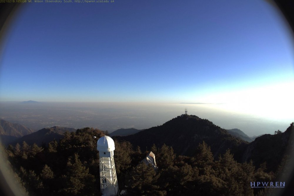
Clear day down here in southwestern Riverside County today, but the webcam view of the Los Angeles Basin from Mount Wilson tells a different story there this afternoon.
 1 point
 -
It's been a mess for sure.I would not rule out March eather some of the La nina years had our biggest snow events in March it would not surpised me in the least if our biggest snow storm this winter happens in March1 point
-
February 1899 was legit. Only December 1983 comes close to it since then in terms of coast to coast cold.1 point
-
I'm so over snowboarding at this point. I came home early today because it was too crowded. I hope for an early spring. This is legit the first time my season was coming to an end and I'm glad it is.0 points
-
Temperature got down to 36F here this morning, the coldest of the month so far.0 points
-
The new japelpeno popper chicken sandwich at Wendy's is pretty good0 points
-
Breezy afternoon here0 points
-
Much cooler today. NWS hinting at a possible chance of precipitation as a trough swings in around March 2-3, but the rest of February looks dry.0 points
-
Inside slider today. It's become the norm here for winter "storms"0 points
-
It's a cold Santa Ana. Sun has reached above 45 degrees today.0 points
-
Random low clouds hung around today, although there were not too many. Looks like they are gone now, however. Sea surface temperatures are falling below normal off the California coast.0 points
-
Just party cloudy and windy for much of this upcoming week. Spring is here early this year.0 points
-
Very hazy today. Can't even see the Santa Ana Mountains even though they're right there.0 points
-
Overcast here as well, kept temperatures warmer than normal overnight.0 points
-
Interesting. How does the tracker work? Threads like these is how this forum used to be. Not just Reddit circlejerking.-1 points
-
No wind here. Just a bright sunny warm day.-1 points
-
I wish European weather forums existed.-1 points


This leaderboard is set to Vancouver/GMT-07:00