
Leaderboard


.thumb.jpeg.e3014abf99ef08a9f9ac2c0cd31b485b.jpeg)
Popular Content
Showing content with the highest reputation on 02/20/24 in all areas
-
Can't believe I'm 60 today! I used to think that was old....19 points
-
Moving to Cashmere on Friday, from Kent. Hoping for some snow before winter says Bye Bye. It’s been so warm and snowless over there recently, thanks El Niño Sunday could be a fun, snowy Leavenworth day trip for me it looks like, and now only 20 minutes away10 points
-
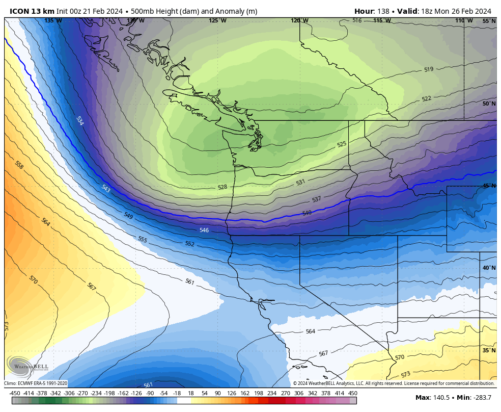
The ICON is digging way better than the 12z. A trend we have seen in all models today.10 points
-
Pepto!!
 9 points
 -
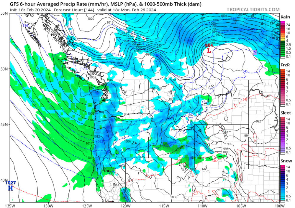
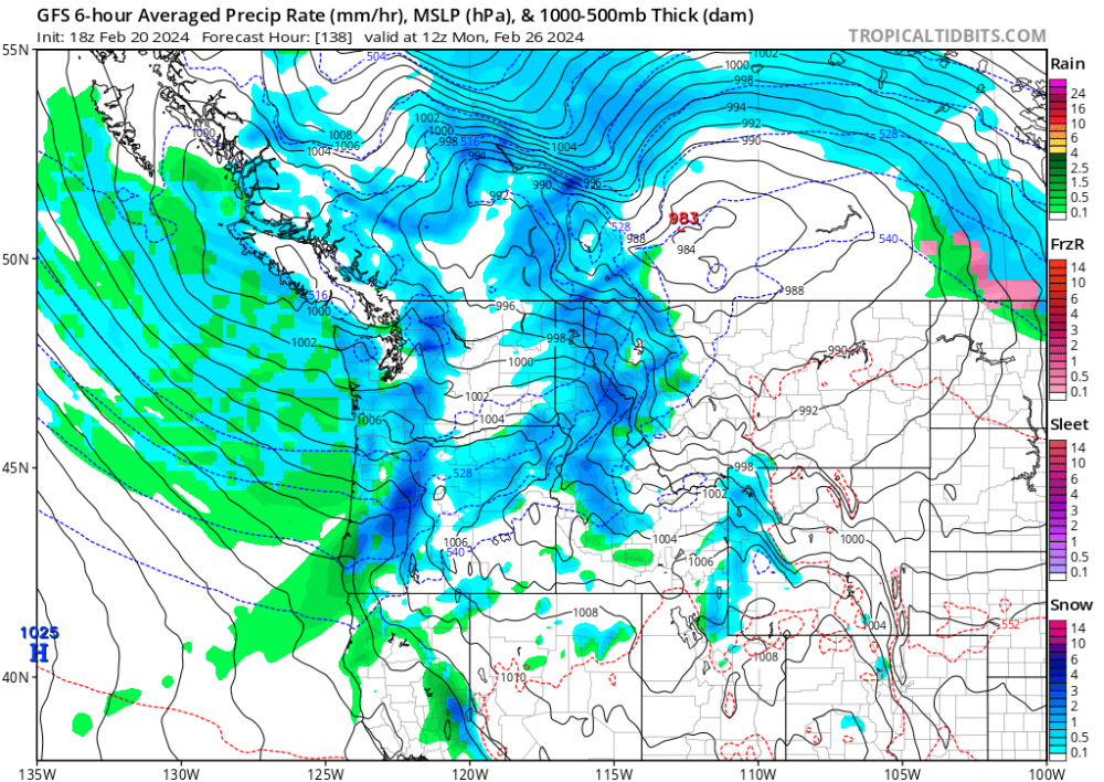
Looks like Monday night is going to be the one to watch. The dead zone between the Pacific and Arctic surface highs makes it to the Seattle area with cold mid levels and cold surface temps, and precip. This is close to really good.8 points
-
The 18z GFS shows snow pretty much down to sea level or close Monday and Tuesday morning as the pattern shifts to cold onshore flow. Everyone should see at least snow in the air. If you have some elevation like at 500-1000 feet or higher you should get some accumulations. If the precipitation is heavy enough it could drag the snow level down to the sea level and then anybody could get accumulations.
 8 points
 -
Summer 2011 was very sunny and mild. Three solid months of mostly dry and beautiful, clear weather. I can't imagine anyone moving because of that June-September stretch. With the mountain snowpack also hanging on late it was some of the best our region ever has to offer. April and May were quite chilly and gloomy, so people's views of that year maybe were clouded (literally!) by that. But most people who have lived here for awhile understand that those are transition months for our region and until recently could almost never be counted on to be barbeque weather months. The problem is that recent transplants do now have a very warped view of those shoulder months since we have seen so many recent summer seasons like 2015, 2018, 2021, and 2023 solidly extend into the first half of spring.8 points
-
I expect every run will be good for your area.8 points
-
We just sold our home in Kent. Found a great rental in town, definitely excited for a change of pace. We’ll see how we’re feeling after the year lease, but yes we love the beauty of the area. This summer is going to be great7 points
-
Props to the gfs for actually doing much better with the first trough. Now others are on board with first trough.
 7 points
 -
The GEFS control brings sub -10 850s for SEA. Tasty!7 points
-
I see a bunch of wet lowland snow events coming up the next 2 weeks. This pattern should be fun.7 points
-
Arctic front does make a push towards the NE WA border on this run. Notches!7 points
-
I can't drive anymore since epilepsy is so bad, my mother in law is developing dementia and my wife doesn't want to move somewhere snowy where she has to drive a lot. I tell her she could just work her job from home in Bend but now that my sister in law is moving back here from Indiana we won't be leaving.7 points
-
I believe Eugene's median annual snowfall is 0". Adjusting your expectations accordingly may help improve your feelings significantly.7 points
-
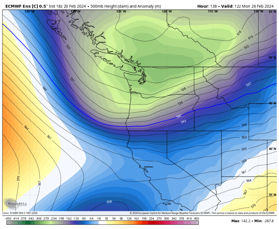
As Andrew might have guessed....I'm a big fan of the ECMWF. Nice sharp trough digging right down the BC Coast.7 points
-
Just a number, I'm 51 and still work circles around the younger guys that work for me.7 points
-
EPS is startting to go big.7 points
-
There is the GFS pepto! Buried in 36-degree snow out here.
 6 points
 -
6 points
-
Big snow event with the Ana front for Puget sound.6 points
-
1964 wasn't an especially wet spring and summer. Lots of clear, cold nights. Not every cool summer is gloomy. The colder background state during the big -PDO phase in the 20th century also meant a lot more progressive patterns in the warm months where cold fronts would clip us from the NW and advect in cooler and relatively dry air behind them. I know you kind of interpret all of those years as uniformly cloudy/damp but the reality was often not that way at all. Seems unheard of today I know since we've see-sawed towards having a stagnant 4CH dominate every aspect of our warm season pattern.6 points
-
18z GFS was a massive step in the right direction.6 points
-
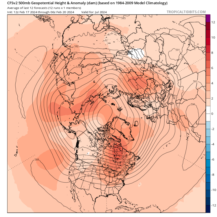
Interesting JJA showing up in the long range stuff.
 6 points
 -
Man that's close! Just noticed this shows 850mb winds are NW. That would not shadow Seattle.6 points
-
Yeah and the op is showing a few CZ opportunities so there will be interesting weather next week but most likely graupel accumulations and possible thunder. Seeing that straight westerly flow regime means I'm more likely to see sunshine than a snowflake. The first weekend in March does intrigue me, especially since the EPS doesn't buy the "50s with an atmospheric river" that the GEFS is hinting at. I'm filing it under "too far in the future to think about" for now. And happy birthday! (edit...to Jim)6 points
-
Not sure why so many people are ignoring how snowy the EPS is.6 points
-
Yeah, those have been spot on all winter long. Happy birthday Jim.6 points
-
A remarkable number of members get pretty darn cold.6 points
-
One more move like this and we're in business.6 points
-
5 points
-
We just need that first trough to lock in for a day longer than what is currently shown for the real cold to get this far. The trend toward sharper digging could result in that outcome on future runs. As it is what is currently being shown should bring some snow for the Seattle area.5 points
-
Tri-Cities might have the worst climate in eastern WA/OR. Winters suck and summers are brutal.5 points
-
Nice pattern into March on GEPS.
 5 points
 -
WE ARE SO DUE5 points
-
Looks like an Ana front on gfs just past 200hrs5 points
-
5 points
-
5 points
-
I was just thinking that that was right around when the pattern shifted to perma-troughing over our region. Nature knew.5 points
-
Happy birthday Jim! 60s are a fantastic decade! With a lot of snow and cool summers! Except for 67. Watch out for 67.5 points
-
Here's 10:1 maps from both sites. Weathermodels doesn't have a pacific northwest map but they do have the states one.
.png.5793954089dbd509f8bd516d8853689a.png)
.thumb.png.42e6ce309571879feb693e404abb869a.png)
 5 points
 -
Also...the terrain bleed thing makes no sense with snow being shown over the ocean either.5 points
-
Gives me 40ish inches, nice! Could be terrain bleed though, so probably more like 30-35 inches of snow.5 points
-
5 points
-
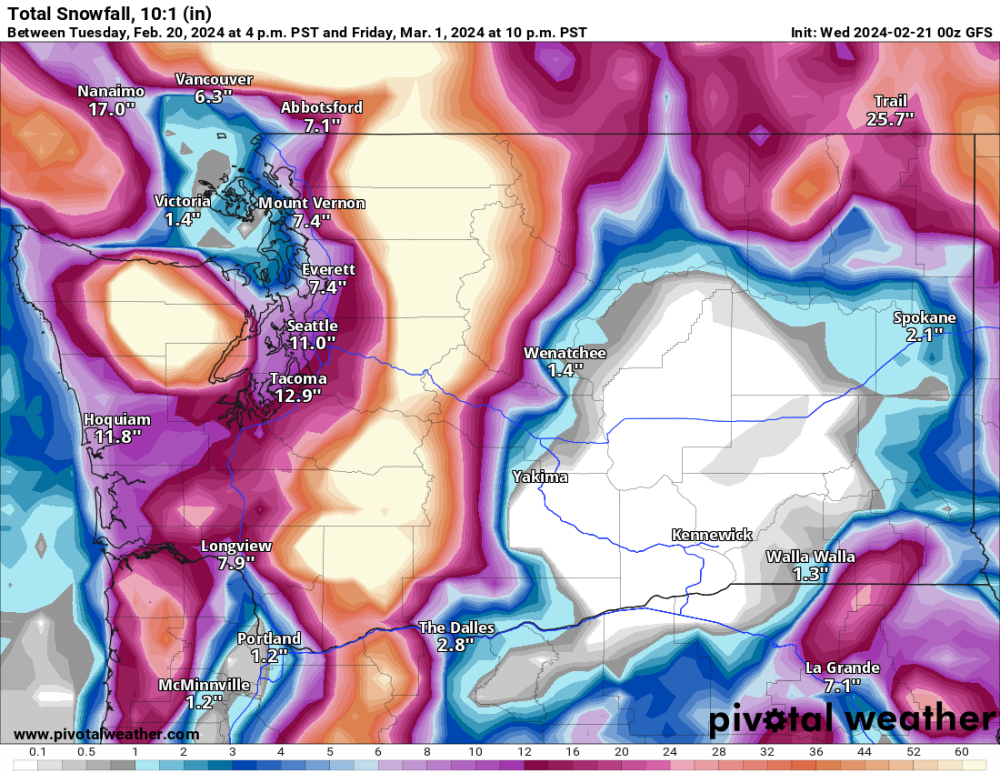
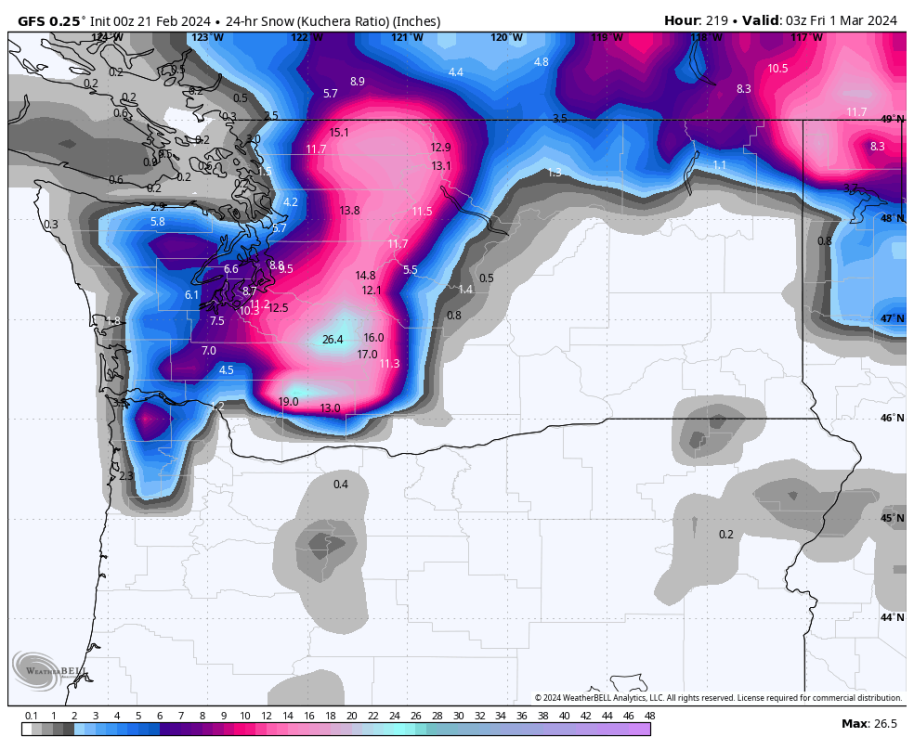
ITS COMING! HALF A FOOT FOR THE WV, AND 2 FEET FOR ME!! Someone post the kuchera map, please and thank you!
.thumb.png.17663ccd6c7fff94f47afc5b292e5ef0.png) 5 points
5 points -
Inversions can persist any time of year, but top tier fake cold season generally runs from about Thanksgiving through the third week of January or so. There’s an exceptions to the rule, but it becomes almost unheard of outside that window to see a true inversion pattern lock in ala 12/05 or 1/13, etc.5 points
-
This model really struggles with snow for some reason.5 points
-
The 00Z ECMWF was pretty close to significant western WA snow event early next week. Much closer than previous runs.5 points
-
That is one helll of a cold blob to work with.5 points
-
5+ feet of snow across higher areas of both the WA and OR Cascades. Would be huge for the ski season which has been limping along for most of the season.
 5 points


.png.291abc1b380bd0acb273911a6e275bd6.png)


.png.ecf1e3b2a2ad0a5258198e8eb375df3b.png)


This leaderboard is set to Vancouver/GMT-07:00