
Leaderboard


Popular Content
Showing content with the highest reputation on 12/21/16 in all areas
-
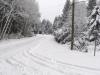
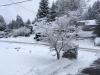
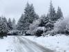
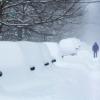
Some before pics from my neighbourhood. Not up for taking after pics as I just had hernia surgery this morning.
 3 points
 -
We're all a little brown on the inside.3 points
-
Only five days out. I'm sure nothing will change.3 points
-
That ridge is about to retrograde in the clown range, FWIW.2 points
-
When it comes to arctic airmasses I'm all about a lack of moderation. LOL!!2 points
-
Forget the models and indices, wild hairs and gut feelings....it will snow this weekend, and I will tell you why I know that as fact... You know how it always seems to rain after you wash your car? Well I "de-crudded" my car and garage today. I rinsed the garage floor to get rid of the remnants of all the melted slush from my car, and I busted out the power washer to clean all the cracks/crevices and underside of the car from all the crap they put on the roads. I have a white car now (haven't had a white car in over 20 years) and I could not stand the filth any more... So anyway, there you have it! You can thank me later!2 points
-
Right on time... http://i.imgur.com/LSx8fJqh.jpg2 points
-
Victoria's Secret models wearing Trump masks?2 points
-
Euro long range is actually pretty nice... Lots of potential there.2 points
-
This. People only care about what the models visually show, not what an extrapolation would look like though lol1 point
-
My god... Watching South Park Woodland Critter Christmas. Golden. Keep in mind it premeiered in December 2004. January 1950 (almost) redux followed. Hmmmm.1 point
-
The savior is running! Prince of peace, born of a virgin.1 point
-
The New Years cold snap that is being discussed may be showing up too early, but I think January will flex its muscles evetually. Your use of the CFS is hilarious. You actually think it's worth a damn ? http://i.imgur.com/mYBy0w7l.jpg1 point
-
If the CFS doesn't have a handle on the next six weeks...1 point
-
At any rate, it'd be nice to get whatever +PNA Tom Foolery the system needs to get out of its system ASAP.1 point
-
Not sure why people where expecting much to begin with1 point
-
Not yet, go back to sleep.1 point
-
As for the cut off low that causes the GFS to look like something my cat threw up after day 10...the ECMWF ensemble is and has been adamant the GFS is totally mishandling that. The ECMWF operational and ensemble control models agree with the ensemble. They all rotate the cutoff low to where it ends up underneath the offshore block. A nice outcome if true. In fact the control model show an all out blast in the 10 to 15 day period.1 point
-
Just can't leave him alone can you? It's so annoying reading post after post and then Tim chimes in with a weird Jim fascination quirk post. I bet you have pics of jim on your bedroom wall.1 point
-
I actually had to go and look to see if the bolded was written by them lol1 point
-
Except for Tim, he is at like 7500 ft in his snowy heaven.1 point
-
Probably higher in elevation than the majortity of the posters here.1 point
-
Isn't Bonney Lake like 400'-500' in elevation?1 point
-
So I'm sensing that it would be preferred if the 12z Euro were to verify over the 18z GFS since the Euro is colder starting Friday late afternoon?1 point
-
Hopefully something to track as we ring in 2017.1 point
-
GFS looks like a fresh warm Christmas Eve dumping of 35 degree liquid poo. 1500' snow level.1 point
-
No one wants to know about my fetishes1 point
-
Temps and rain should do a pretty good job of taking most away unfortunately unless we can add more than a couple inches on Friday.1 point
-
1 point
-
NYE storm still showing up on the 12z EURO with a powerful CO LOW...with a vortex near Hudson Bay, somewhat of a Greenland Block and a western N.A. Ridge...IMO, this storm will be more of a west/east storm track that doesn't cut to fast. http://www.tropicaltidbits.com/analysis/models/ecmwf/2016122112/ecmwf_mslpaNorm_us_11.png http://www.tropicaltidbits.com/analysis/models/ecmwf/2016122112/ecmwf_mslpaNorm_namer_11.png1 point
-
I have a feeling he is waiting for it to reload for the EC folks, bc in my humble opinion, those from I-80 on north will see a return of a wintry pattern at the start of the New Year. Those on the EC have important variables to overcome: PNA (SE Ridge), NAO and AO. Say, from the OV and points NW of there, this part of the nation will see the cold air fight and bleed SE first before the EC sees some excitement. Even CPC see's a near normal pattern in the 6-10 day (I-80 on north)...and I didn't see this map until after I literally typed the paragraph above! Ha! http://www.cpc.ncep.noaa.gov/products/predictions/610day/610temp.new.gif1 point
-
We're alll gonna die someday!!!1 point
-
Do we care about what the NAM has to say? Or.... http://www.tropicaltidbits.com/analysis/models/namconus/2016122118/namconus_ref_frzn_nwus_39.png http://www.tropicaltidbits.com/analysis/models/namconus/2016122118/namconus_ref_frzn_nwus_41.png1 point
-
Why are you even looking 216 hours out?1 point
-
Looking like a 35/31 day!1 point
-
Truth. Sadly all the people live on a small sliver of land near sea level making our home prices outrageous.1 point
-
I was teasing... But I agree.1 point
-
Every region of the globe is capable of snow except King County1 point
-
A lot of ppl in MN, esp the Northwoods, are going to have an un-welcome snow pack defeat from this system. TBH, this season is a balancing act for the Dakotas which haven't seen a solid winter in many, many years. Even during the past couple cold winters, they escaped a majority of the big storms.1 point
-
My local forecast calls for thunderstorms Christmas day. That should get us in the festive mood here. BTW, did you know you can find Christmas cards with snow scenes but none with thunderstorm scenes? I called Hallmark about it this morning... I also had to change the lyrics to "Sleigh Ride". I now sing... "....come on it's lovely weather for a storm chase together with you....da da daaaaaaaaaaa....da da daaaaaaaaaaa." (The forum needs a rimshot button....) Sorry for all the digression there....1 point
-
Both GFS/EURO showing a pretty big storm potential Day 8/9 period cutting up towards the Lakes. Euro showing a snow storm it looks like while GFS a little warm.1 point
-
That's good thing to hear then coming from you. I just get deeply concerned when I see a ridge trying to develop over us and in turn sending all the Arctic air to the Midwest/East coast. It seems it takes a while for the pattern to reset itself again if we miss out on the Arctic air. I can see where the EURO looks better than the GFS but to me there seems to be lots of similarities between the 2 at day 10. http://www.tropicaltidbits.com/analysis/models/gfs/2016122100/gfs_z500a_namer_41.png http://www.tropicaltidbits.com/analysis/models/ecmwf/2016122100/ecmwf_z500a_namer_11.png1 point
-
Two guys arguing about a climate they live at least a day's drive from.1 point
-
Both GFS/GGEM have an open wave that lays down 2-4" for parts of the Midwest/Lakes Friday night into Christmas Eve.1 point
-
And I am giving discussion. I talk about facts all the time. I give evidence and support what I say. Just because you don't agree doesn't mean it's not discussion. I hate what most of you guys have to say, but it's still discussion because it's what you believe. Sorry I don't come on here and just say #MAGA!!1 point
-
One month till Trump inauguration!!!1 point
-
There's a massive difference between discussion and arguing for the sake of arguing. How in the world do you propose that we fight these people then? With teddy bears and candy bars or what? War is not supposed to be nice. Fighting these people like a bunch of pansies hasn't worked in the least bit. Do you think these Islamic groups give a rats behind about you or me and what targets they take? Innocent people die in war. It's unfortunate but it is what it is. Obama may have not called what little ineffective work we have done over there war exactly but at least one side is at war and they have no f*cks to give. Putin has been largely restrained by the fact that we do not have a leader who will support the action necessary to solve the problem. Its going to take more than one country to make it happen. We will have a leader who is not afraid to take care of it very soon.1 point
-
Looks like ISIS finally messed with someone who isn't a coward.1 point


.thumb.jpeg.e3014abf99ef08a9f9ac2c0cd31b485b.jpeg)


This leaderboard is set to Vancouver/GMT-07:00