
Leaderboard


Popular Content
Showing content with the highest reputation on 12/26/21 in all areas
-
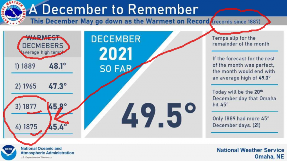
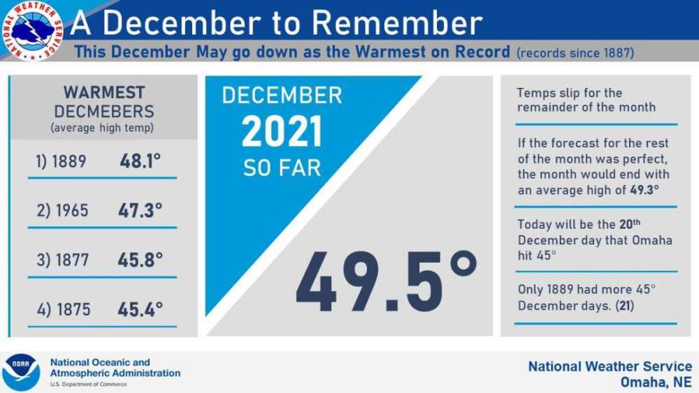
@OmahaSnowFanWhoever did that chart must have been drunk. Sub headline notes records since 1887, yet two of the years are 1877, 1875. Misspelled "Decembers" in the left column heading. There must have been some serious climate change going on in the late 1800s...3/4 warmest Omaha Decembers then.
 7 points
 -
Looks like the AO and NAO wanna playball. The AO dipping almost to -5 on the 4th, this should really energize the jet and allow the artic air to merry up with these next few storm systems.5 points
-
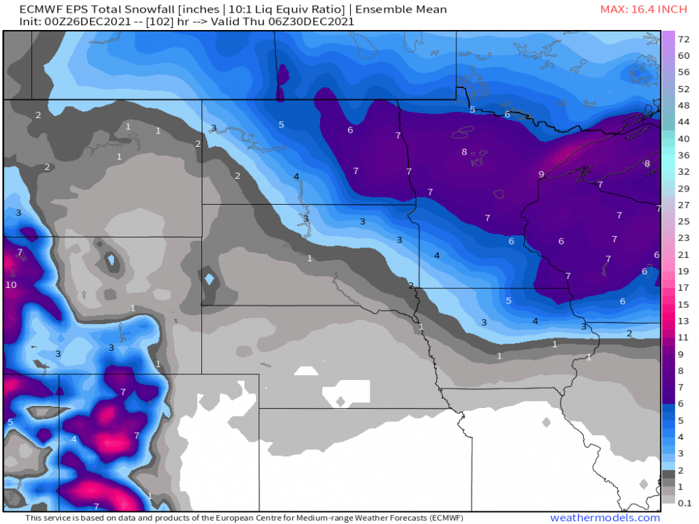
06z GFS coming in HOT again...don't tease me and pull me in....but my goodness, this system has everything going for it to hit a large part of our central/eastern Sub. This run sorta showed it slowing down and wrapping up as it tracked up the OHV. Interesting trends the past 12-24 hours...only about a week to go....should be an exciting week of storm tracking leading up to the New Year.
 5 points
 -
Flew to NYC for the weekend and man the airports are a mess. Had major delays w/ my flight returning back. Numerous flights cancelled. Anyways, had plenty fun there in the "Big Apple." Luv being there during Christmas! Back to weather now..haven't had a chance to see what is going on, but I will catch up eventually and have my say. In the meantime, some snow coming here in SMI tanite, maybe some Ice.4 points
-
Looks like ND got some decent snows outta this Christmas day system...general 2-7" with more on the way!
 4 points
 -
The Euro is now teasing something good for New Year's Day as well. At least there is potential, if the cold and upper energy can link up just right.
 4 points
 -
...and I've joined the party! Looks like a sneaky last-minute scenario. I will take it! 1"+ per hour pound-town! Winter Weather Advisory URGENT - WINTER WEATHER MESSAGE National Weather Service Detroit/Pontiac MI 1049 PM EST Sun Dec 26 2021 MIZ060>063-068>070-075-076-270915- /O.NEW.KDTX.WW.Y.0010.211227T0800Z-211227T1400Z/ Shiawassee-Genesee-Lapeer-St. Clair-Livingston-Oakland-Macomb- Washtenaw-Wayne- Including the cities of Owosso, Flint, Lapeer, Port Huron, Howell, Pontiac, Warren, Ann Arbor, and Detroit 1049 PM EST Sun Dec 26 2021 ...WINTER WEATHER ADVISORY IN EFFECT FROM 3 AM TO 9 AM EST MONDAY... * WHAT...Snow with some mixed precipitation expected. Total snow accumulations of around 2 inches with ice accumulations of a light glaze possible. * WHERE...Shiawassee, Genesee, Lapeer, St. Clair, Livingston, Oakland, Macomb, Washtenaw and Wayne Counties. * WHEN...From 3 AM to 9 AM EST Monday. * IMPACTS...Plan on slippery road conditions. The hazardous conditions will impact the morning commute. * ADDITIONAL DETAILS...High impact snowfall rates appear likely during the 4AM to 7AM morning commute. Snowfall rates exceeding 1 inch per hour will be possible with total snowfall accumulations of around 2 inches in less than 3 hours time. PRECAUTIONARY/PREPAREDNESS ACTIONS... Slow down and use caution while traveling3 points
-
A nice thunderstorm just moved through Cedar Rapids and produced a decent amount of pea size hail with a few pieces up to 3/8 inch. That's not something we see every Boxing Day.3 points
-
I started a thread for the NYD storm New Year's Day Storm - The Great Lakes and Great Plains - The Weather Forums3 points
-
18z Euro would give me my first snow accumulation of the year, but under an inch, so not anything to get excited about, but northeast Iowa does quite well. 6-8" for Clayton, Fayette, Allamakee and Winneshiek counties, among others.3 points
-
Spent the last 2 days in bed with a fever . Your original post said it all, health and fam. Two biggest things we often take for granted. Merry Christmas to everyone.3 points
-
18z GEFS continues to work SE for NYD storm.3 points
-
Brutal cold behind the storm3 points
-
@jaster220, Jan '99 repeat??? Actually, this run actually resembles more of the way we opened Jan '14....that was an epic week over here. Chicago had 2 major storms that dumped 10"+ in the span of a week. If the models continue the positive trends for the Jan 6th-8th period, we could be talking a repeat scenario. This would be one hellova way to open up 2022!
 3 points
 -
Clinton, this is the storm that should deliver the 1st "share the wealth" across our Sub. The Euro was having its typical issues holding back energy in the SW but the GFS always kicked it out quicker and was consistently showing a wound up storm. I think that's why it has the right idea since our pattern, esp the STJ, is on fire! Does it slow? I mean, it could but I don't see it slowing down to a crawl. It literally snows for 24+ hours in my neck of the woods depending on how this storm develops. IMO, the flow is to fast for it to slow down any farther. Maybe in later future cycles it will slow down, more so towards March into the early Spring months. I think this is our 1st legit chance of seeing a big dog this season! That pattern is ripe for it. I'm very encouraged to see ALL the global models dialing in on the SW energy ejecting out towards "The Slot"...0z CMC/0z UKIE on board as well. The great thing leading up to this storm is the Arctic Air will be in place allowing the ground to freeze up. The lakes are all "open for business" and folks near MKE/Chicago could be also dealing with Lake Enhancement. Man, this is quite the Christmas surprise to see the models all come into agreement overnight. This is the first time I'm looking at the models bc I was out all evening at my sisters big Christmas party.
 3 points
 -
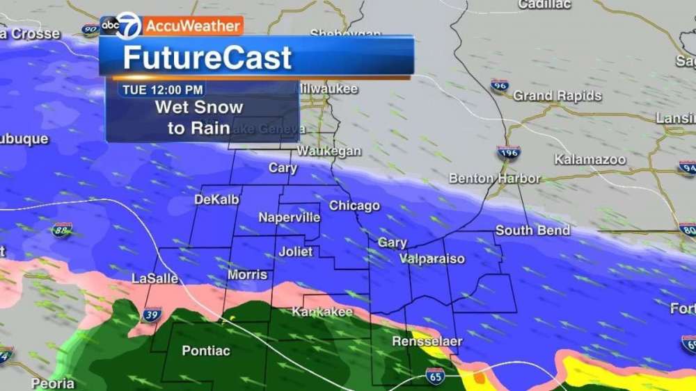
ABC7 Chicago’s Phil Schwarz posted this on Facebook for Tuesday, calling it the possible first accumulating snow for the Chicago area.
 3 points
 -
0z GFS going large with a share the wealth storm to open up the New Year. Very reminiscent of late Oct storm you mentioned on this run. Any chance it slows a little?
 3 points
 -
This would be nice!!
 3 points
 -
FOR THE RECORD....tonight into tomorrow totals ACCUweather- 6-10" tonight Local Met 5-7" NWS 3" Every model shows 6+" so curious to see what happens2 points
-
Feel better Amigo! Drink some Green Tea w/ honey, or Tumeric Ginger. As far as the NYD weekend storm..had no idea about this.......Ummm....tbh, I would not even mess w/ this storm yet...way too far out2 points
-
These storms popping up I did not expect! Had some nice flashes of lightning!2 points
-
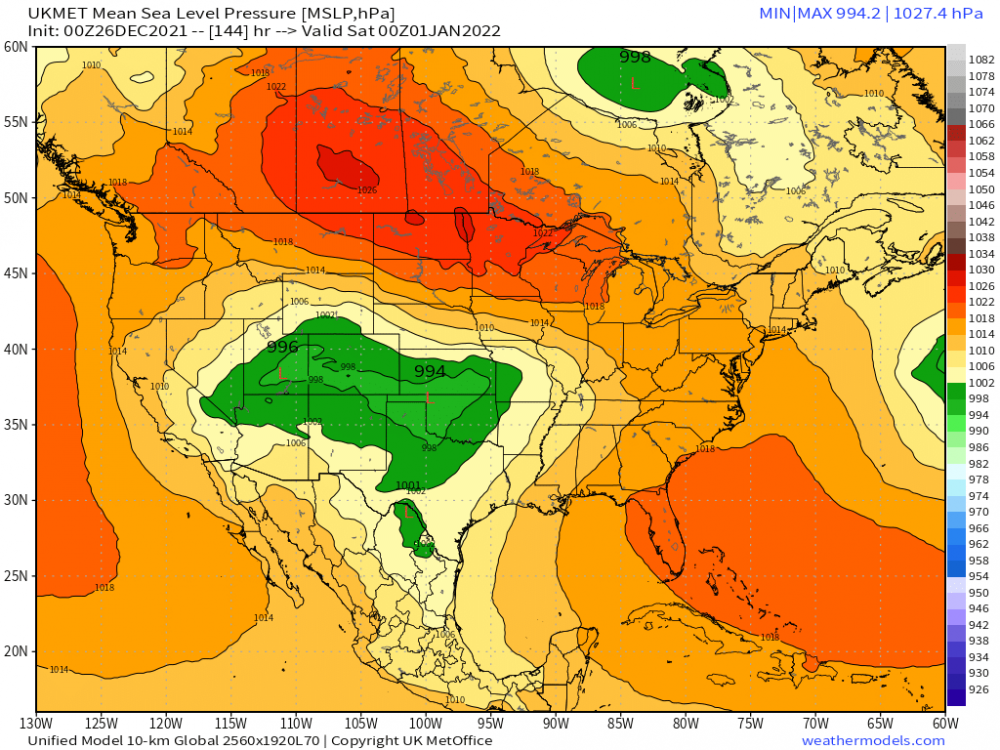
GRR seems sold on a storm with SMI winners and losers tbd. - New Year`s Day storm potential The first significant winter storm of the season is taking shape for the weekend as a deep western CONUS trough moves east and surface cyclone tracks over or just south of Lower Michigan with plenty of Gulf Moisture. Cold surface ridging is anchored to the north, with model soundings showing heavy snow potential across much of the forecast area as dynamical cooling occurs and cold air is drawn into the storm. THere is still ensemble spread on the track, which will pinned down better during the week.2 points
-
Upper level low between Hawaii and SoCal kicking up some thunderstorms and some of that high level moisture could get pulled north if that cyclone over Seattle dives straight south. Potential setup for more rain and snow.2 points
-
UK continues to be onboard as well.2 points
-
12z GEFS is SE of the OP run....12z Canadien is similar to the GFS...it appears likely we are going to be tracking a New Year's Day storm. Prob start a thread later this afternoon.2 points
-
Quick! Everyone post this all over social media since it's definitely going to happen!!2 points
-
Walking around last night during our band of ocean-effect thundersnow... EDIT: IT WON'T END!!! You may hear about the Tohoku Japan December '21 snowfall in the international news tomorrow. Still snowing 3-5" per hour.2 points
-
0z EPS dialing in on a much colder and active pattern to open JAN '22...legendary for the MW/GL's??? Could be shaping up for one heckova ride if these trends persist. Gotta tell ya, I'm starting to feel pretty good about this pattern changing and locking in for a while. The LES belts should be seeing some epic snow totals with every round of Arctic Air. This is something I would like to see happen or even experience bc what I think is setting up for the 1st 10 days of JAN could be memorable.
 2 points
 -
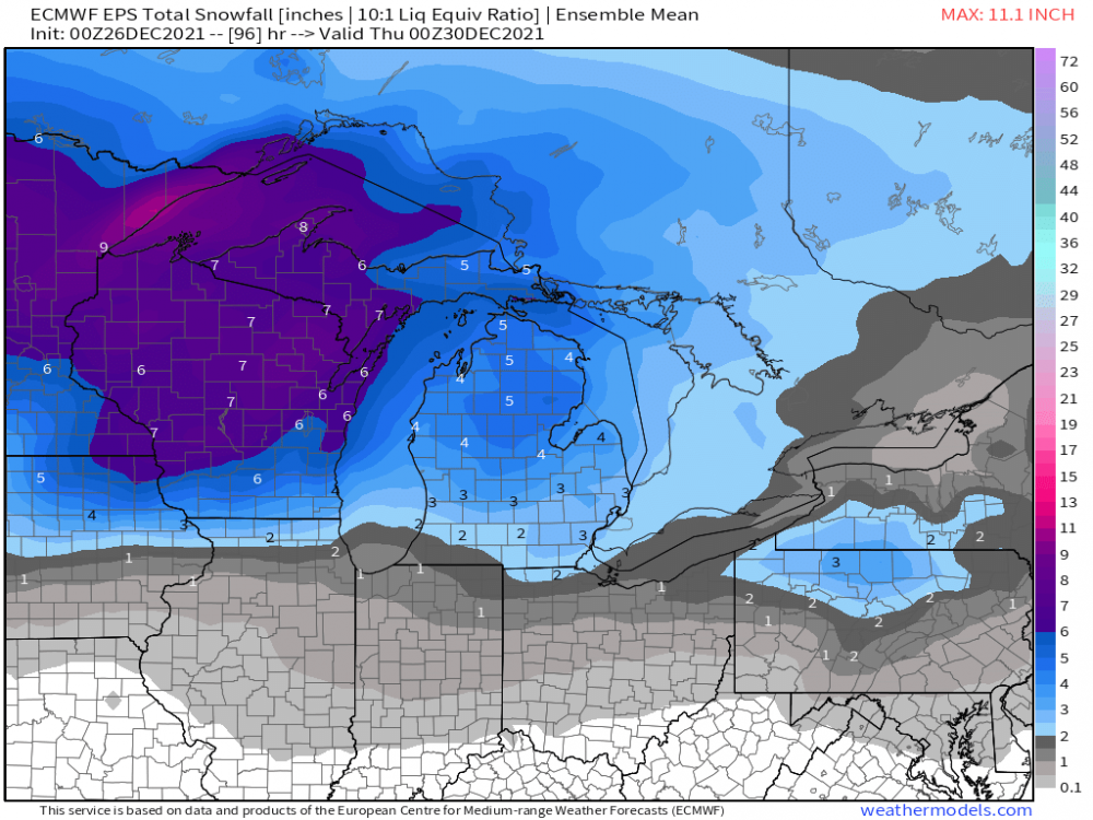
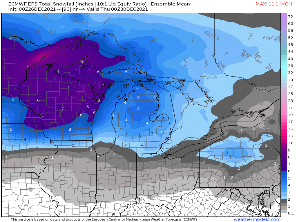
0z EPS for 1st wave... 2nd Wave totals...
 2 points
 -
0z CMC very similar to the GFS with the New Years storm.2 points
-
Models have been showing this for a few days now and all are in agreement of a storm impacting the mid section of the country. The GFS has shifted further north, the Euro has weakened a bit, but both are showing plenty to keep an eye on. The Canadian is similar to the Euro on placement but as strong as the GFS. 18z GFS 12z Canadian 12z Euro1 point
-
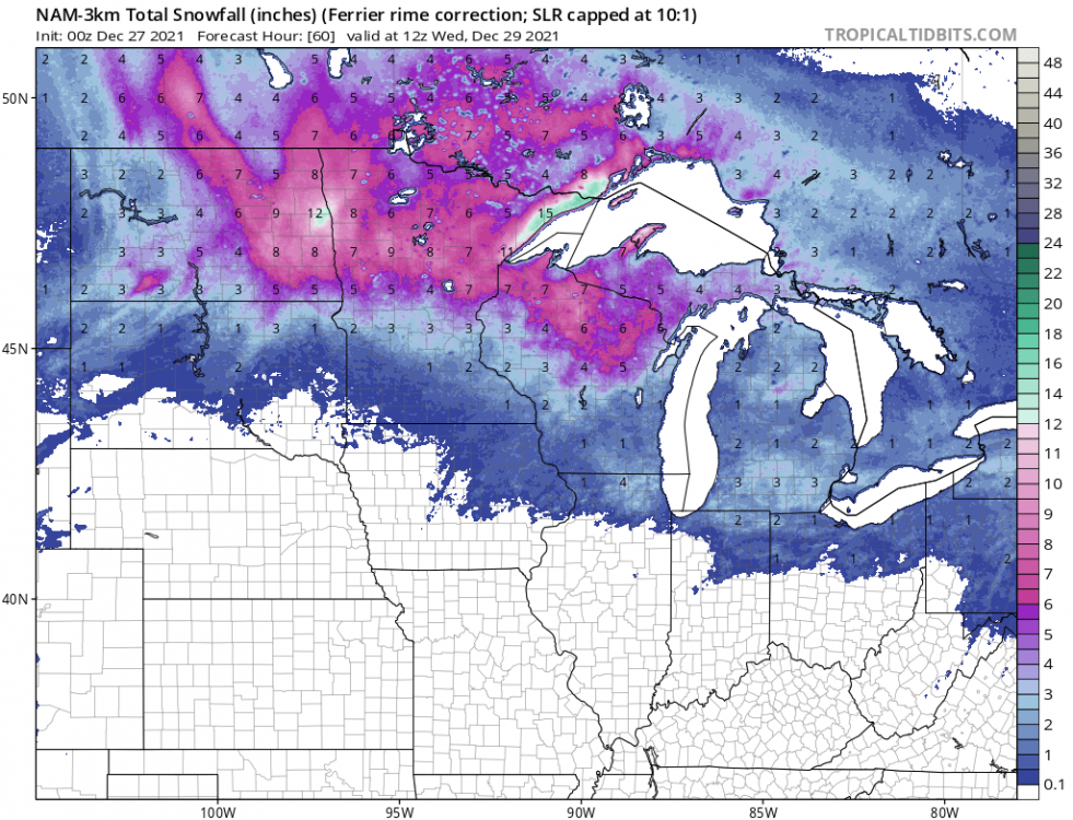
GDPS - Interesting bullseye in ne IA (RDPS shows the same)
 1 point
 -
Cmon GFS just shift a smidge SE please.1 point
-
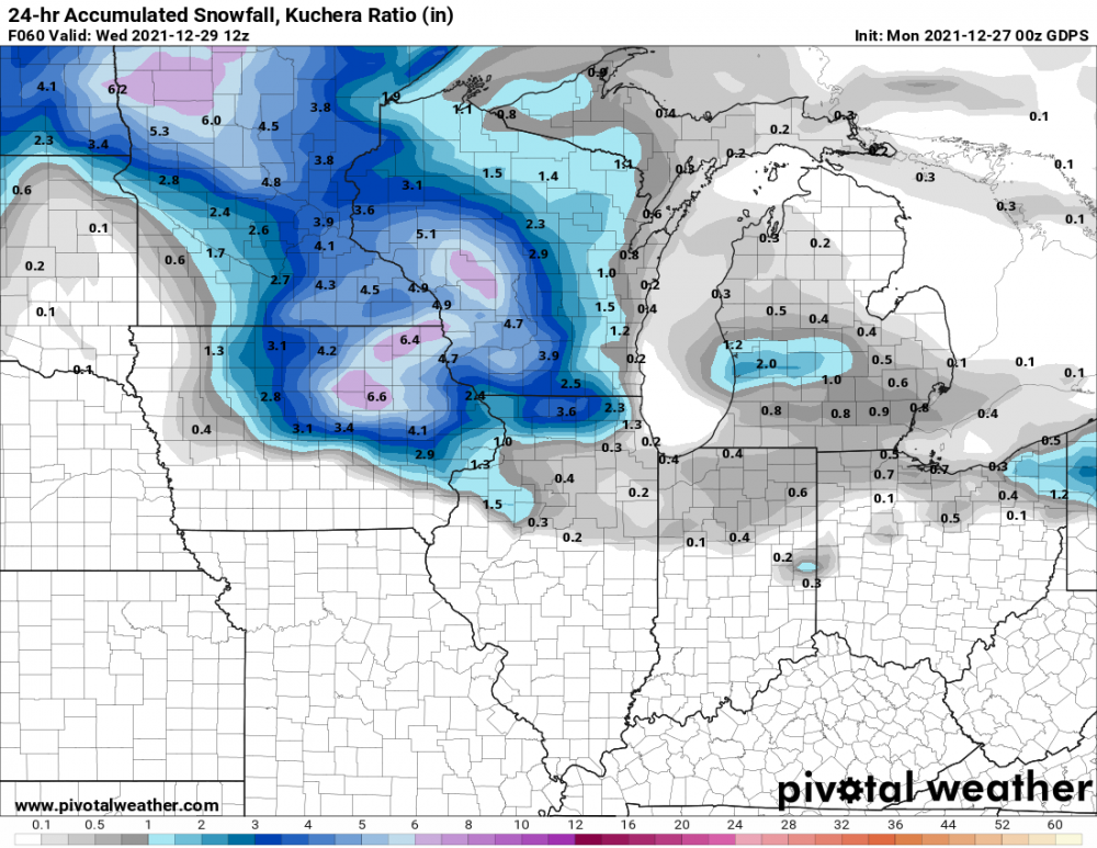
3k NAM gives me only 0.1, but gets me up to 3" with the 2nd wave that looks to remain snow quite a bit longer.
 1 point
 -
I hope you feel better soon. I'm right on SE fringe with ya, hope things keep trending colder for us.1 point
-
Get well my friend!1 point
-
A big positive, it's not 240+ out, lol. I like your take. I'm riding the SE fringe attm.1 point
-
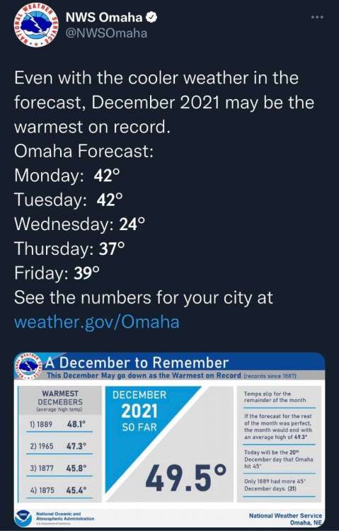
Not surprising, but we're going to shatter our all time warmest December here
 1 point
 -
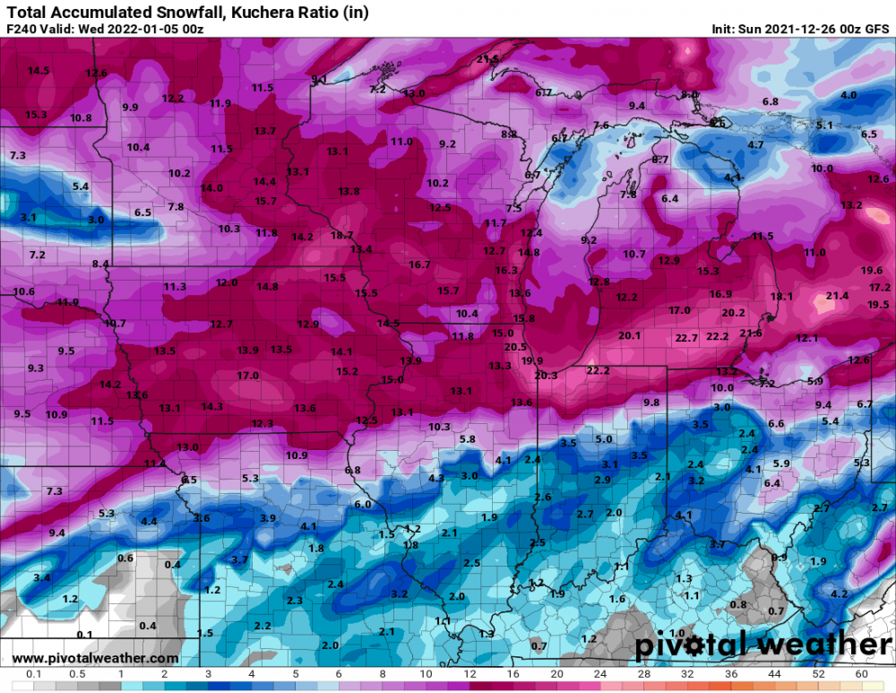
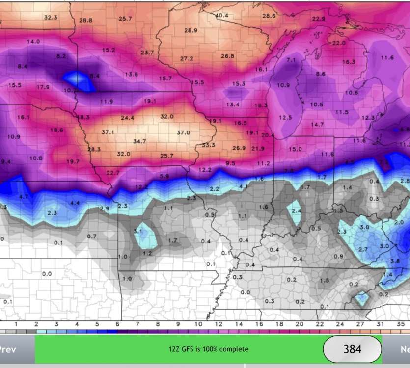
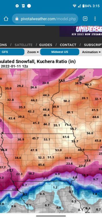
I know this is a GFS giggle map, but even on those, I can't remember seeing 70+ inches!
 1 point
 -
Looking like I am going to get a good thumping tonight. Point went from 3 to 5 and is now 3 to 7. Curious to see how it pans out.1 point
-
Euro came in weaker this run, but still has the storm.1 point
-
Nothing like a good storm to clear all the gunk out of the air. Rain and gusty winds woke me up at 2am a couple of times, but the result is the kind of day our chamber of commerce used to put on postcards. It was pretty effective at bringing in transplants a century ago.1 point
-
On my phone, but wanted to share that the 12z EPS has trended a lot better for snow chances into the MW/Lower Lakes heading into the New Year. It’s also picking up on the 6th/7th storm with a ton of blocking up in Canada. Fun times on the horizon!1 point
-
The Euro shows >0º 850 temp over eastern Iowa when the precip moves in, then suddenly plunges the 850 temp, apparently due to dynamic cooling, before the warmer air moves back in. I'm skeptical the atmosphere will be cold enough to support a good snow thump here. Other models are mix to rain.1 point
-
Merry Christmas from Jacksonville, FL!1 point
-
Merry Christmas from SoCal! Probably the last one I'll be spending here1 point
-
Merry Christmas.... I sure was a mild overnight with readings in the low 50's to upper 40's before a not so cold front came through. Now even during the overnight hours the temperature reached 52 at Grand Rapids and Lansing and 51 at Muskegon. Those readings are good for the 2nd warmest Christmas at Muskegon, the 4th warmest at Grand Rapids and the 7th warmest at Lansing. There was 0.09" of rain fall here at my house. At this time it is cloudy and 43 here.1 point
-
One of the best Christmas songs that seems to always bring me the chills...this vid came out in 2015 and one that I remember vividly...2 things from this video: 1) It captures how we should all come together 2) It shows the Human Spirit of Love and Compassion...Christ is born! https://www.youtube.com/watch?v=XI2c9yptr4U1 point
-
Merry Christmas everyone!1 point
-
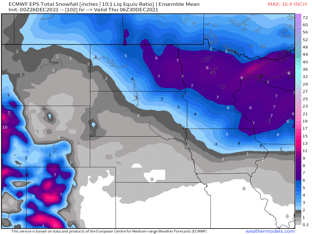
00z with a Xmas gift above the Cheddar Curtain. Starts snowing Sunday and just keeps rolling.
 1 point


This leaderboard is set to Vancouver/GMT-07:00